Orange County Sketch File 4a
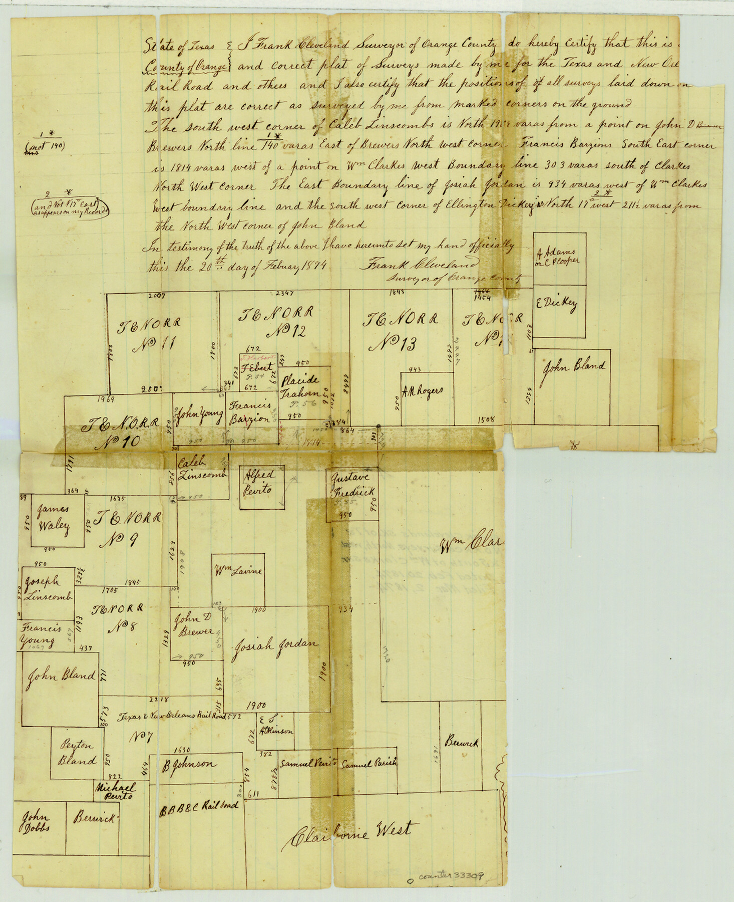
[Sketch of T. & N. O. R.R. Co. surveys north, west and south of William Clark's survey]
-
Map/Doc
33309
-
Collection
General Map Collection
-
Object Dates
2/20/1874 (Creation Date)
3/2/1874 (File Date)
-
People and Organizations
Frank Cleveland (Surveyor/Engineer)
-
Counties
Orange
-
Subjects
Surveying Sketch File
-
Height x Width
16.0 x 13.0 inches
40.6 x 33.0 cm
-
Medium
paper, manuscript
Part of: General Map Collection
Nolan County Sketch File 14

Print $20.00
- Digital $50.00
Nolan County Sketch File 14
1927
Size 32.6 x 20.0 inches
Map/Doc 42164
Cass County Working Sketch 28

Print $20.00
- Digital $50.00
Cass County Working Sketch 28
1979
Size 16.0 x 16.8 inches
Map/Doc 67931
Fort Bend County Rolled Sketch 5

Print $20.00
- Digital $50.00
Fort Bend County Rolled Sketch 5
1956
Size 34.6 x 33.5 inches
Map/Doc 5895
Kerr County Sketch File 13

Print $11.00
- Digital $50.00
Kerr County Sketch File 13
1927
Size 16.9 x 8.1 inches
Map/Doc 28883
Marion County Boundary File 2

Print $6.00
- Digital $50.00
Marion County Boundary File 2
Size 11.2 x 8.7 inches
Map/Doc 56818
Jefferson County Rolled Sketch 9

Print $20.00
- Digital $50.00
Jefferson County Rolled Sketch 9
Size 36.6 x 47.0 inches
Map/Doc 9276

Hall County Sketch File 13

Print $20.00
- Digital $50.00
Hall County Sketch File 13
Size 15.7 x 24.2 inches
Map/Doc 11606
Kaufman County Boundary File 6b

Print $6.00
- Digital $50.00
Kaufman County Boundary File 6b
Size 14.2 x 8.5 inches
Map/Doc 55966
Kimble County Rolled Sketch 29

Print $20.00
- Digital $50.00
Kimble County Rolled Sketch 29
Size 27.5 x 31.0 inches
Map/Doc 6519
[Surveys in Austin's Colony along the San Antonio Road and the Navasota River]
![202, [Surveys in Austin's Colony along the San Antonio Road and the Navasota River], General Map Collection](https://historictexasmaps.com/wmedia_w700/maps/202.tif.jpg)
Print $20.00
- Digital $50.00
[Surveys in Austin's Colony along the San Antonio Road and the Navasota River]
1833
Size 16.1 x 34.7 inches
Map/Doc 202
Smith County Working Sketch 4

Print $20.00
- Digital $50.00
Smith County Working Sketch 4
1913
Size 13.5 x 17.9 inches
Map/Doc 63889
You may also like
Refugio County Sketch File 8a

Print $2.00
- Digital $50.00
Refugio County Sketch File 8a
Size 8.1 x 10.2 inches
Map/Doc 35253
Morris County Rolled Sketch 2A

Print $20.00
- Digital $50.00
Morris County Rolled Sketch 2A
Size 22.6 x 17.7 inches
Map/Doc 10285
[Portion of Harris County]
![78481, [Portion of Harris County], General Map Collection](https://historictexasmaps.com/wmedia_w700/maps/78481.tif.jpg)
Print $2.00
- Digital $50.00
[Portion of Harris County]
Size 7.9 x 5.1 inches
Map/Doc 78481
Map of Grayson County

Print $20.00
- Digital $50.00
Map of Grayson County
1859
Size 22.6 x 19.5 inches
Map/Doc 3600

Taylor County Rolled Sketch 22

Print $20.00
- Digital $50.00
Taylor County Rolled Sketch 22
1950
Size 23.3 x 26.7 inches
Map/Doc 7915
Navigation Maps of Gulf Intracoastal Waterway, Port Arthur to Brownsville, Texas

Print $4.00
- Digital $50.00
Navigation Maps of Gulf Intracoastal Waterway, Port Arthur to Brownsville, Texas
1951
Size 16.7 x 21.6 inches
Map/Doc 65426

Liberty County Sketch File 17

Print $2.00
- Digital $50.00
Liberty County Sketch File 17
Size 8.2 x 3.2 inches
Map/Doc 29919
Hale County Working Sketch Graphic Index

Print $20.00
- Digital $50.00
Hale County Working Sketch Graphic Index
1931
Size 46.4 x 36.9 inches
Map/Doc 76562
Young County Sketch File 10

Print $20.00
- Digital $50.00
Young County Sketch File 10
Size 14.1 x 17.7 inches
Map/Doc 12711
Right of Way and Track Map - Houston & Texas Central R.R. operated by the T. and N. O. R.R. Co. - Fort Worth Branch

Print $40.00
- Digital $50.00
Right of Way and Track Map - Houston & Texas Central R.R. operated by the T. and N. O. R.R. Co. - Fort Worth Branch
1918
Size 26.5 x 58.3 inches
Map/Doc 82861