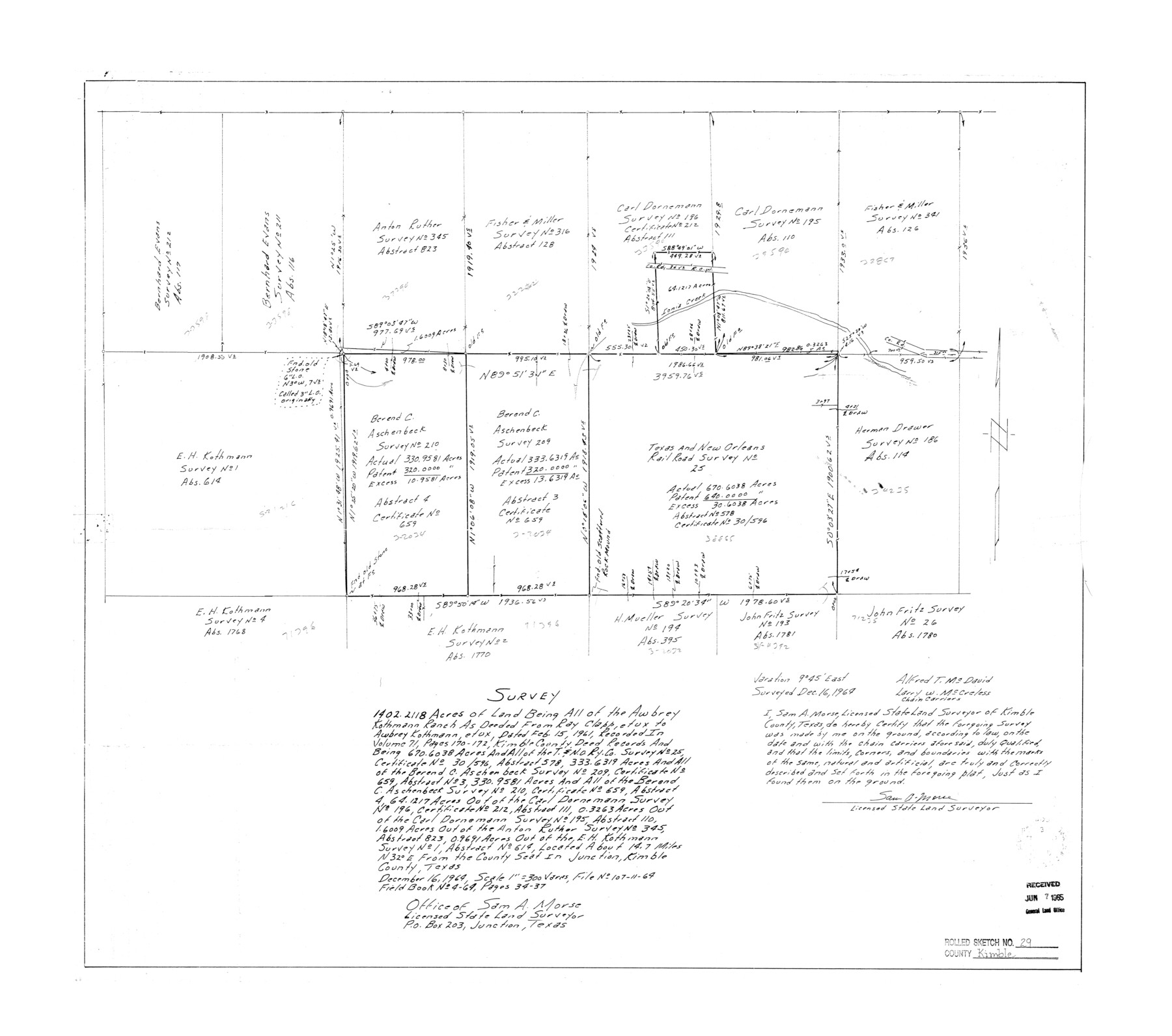
Kimble County Rolled Sketch 29
[Sketch of survey 25, T. & N. O. R.R. and surveys 209 and 210, Berend C. Aschenbeck and surrounding area]
-
Map/Doc
6519
-
Collection
General Map Collection
-
Object Dates
1964/12/16 (Survey Date)
1965/6/7 (File Date)
-
People and Organizations
Sam A. Morse (Surveyor/Engineer)
Alfred T. McDavid (Chainman/Field Personnel)
Larry W. McCreless (Chainman/Field Personnel)
-
Counties
Kimble
-
Subjects
Surveying Rolled Sketch
-
Height x Width
27.5 x 31.0 inches
69.9 x 78.7 cm
-
Scale
1" = 300 varas
Part of: General Map Collection
Freestone County

Print $20.00
- Digital $50.00
Freestone County
1988
Size 45.8 x 42.6 inches
Map/Doc 73152
Midland County Working Sketch 27

Print $20.00
- Digital $50.00
Midland County Working Sketch 27
1963
Size 41.6 x 38.9 inches
Map/Doc 71008
Map of Webb County

Print $20.00
- Digital $50.00
Map of Webb County
1879
Size 36.8 x 25.4 inches
Map/Doc 4131
Controlled Mosaic by Jack Amman Photogrammetric Engineers, Inc - Sheet 43

Print $20.00
- Digital $50.00
Controlled Mosaic by Jack Amman Photogrammetric Engineers, Inc - Sheet 43
1954
Size 20.0 x 24.0 inches
Map/Doc 83502
Hardin County

Print $20.00
- Digital $50.00
Hardin County
1894
Size 46.8 x 43.4 inches
Map/Doc 16846
Val Verde County Sketch File 57

Print $28.00
- Digital $50.00
Val Verde County Sketch File 57
2009
Size 11.0 x 8.5 inches
Map/Doc 89235
Foard County Sketch File 6

Print $4.00
- Digital $50.00
Foard County Sketch File 6
1875
Size 10.2 x 8.4 inches
Map/Doc 22808
Rockwall County Working Sketch 4

Print $20.00
- Digital $50.00
Rockwall County Working Sketch 4
1966
Size 34.9 x 28.9 inches
Map/Doc 63596
Brazoria County Working Sketch 24

Print $20.00
- Digital $50.00
Brazoria County Working Sketch 24
1963
Size 35.7 x 25.0 inches
Map/Doc 67509
Travis County Working Sketch 44

Print $20.00
- Digital $50.00
Travis County Working Sketch 44
1974
Size 22.3 x 26.4 inches
Map/Doc 69428
Lamb County Working Sketch 3

Print $20.00
- Digital $50.00
Lamb County Working Sketch 3
1962
Size 32.1 x 37.7 inches
Map/Doc 70276
Flight Mission No. DIX-3P, Frame 165, Aransas County

Print $20.00
- Digital $50.00
Flight Mission No. DIX-3P, Frame 165, Aransas County
1956
Size 17.8 x 18.4 inches
Map/Doc 83771
You may also like
Political Chief of Nacogdoches to Secretary of the State Government (PCNSS)

Political Chief of Nacogdoches to Secretary of the State Government (PCNSS)
Size 12.7 x 9.5 inches
Map/Doc 94265
Terry County Sketch File 1

Print $20.00
- Digital $50.00
Terry County Sketch File 1
1903
Size 25.7 x 23.4 inches
Map/Doc 12428
Flight Mission No. BQR-3K, Frame 162, Brazoria County

Print $20.00
- Digital $50.00
Flight Mission No. BQR-3K, Frame 162, Brazoria County
1952
Size 18.7 x 22.4 inches
Map/Doc 83989
Parker County Sketch File 46

Print $26.00
- Digital $50.00
Parker County Sketch File 46
1957
Size 11.2 x 8.5 inches
Map/Doc 33615
Newton County Working Sketch 22

Print $20.00
- Digital $50.00
Newton County Working Sketch 22
1952
Size 25.3 x 43.2 inches
Map/Doc 71268
Zapata County Rolled Sketch 12A

Print $40.00
- Digital $50.00
Zapata County Rolled Sketch 12A
1917
Size 54.0 x 40.0 inches
Map/Doc 10165
Flight Mission No. BQR-5K, Frame 67, Brazoria County

Print $20.00
- Digital $50.00
Flight Mission No. BQR-5K, Frame 67, Brazoria County
1952
Size 18.7 x 22.5 inches
Map/Doc 84012
Austin including Bergstrom AFB, Hays, Mansfield Dam, McKinney Falls State Park, Oak Hill, Rollingwood, San Leanna, Sunset Valley and West Lake Hills - also portions of Pflugerville

Austin including Bergstrom AFB, Hays, Mansfield Dam, McKinney Falls State Park, Oak Hill, Rollingwood, San Leanna, Sunset Valley and West Lake Hills - also portions of Pflugerville
Size 38.4 x 25.6 inches
Map/Doc 94375
Mills County Sketch File 10 1/2

Print $24.00
- Digital $50.00
Mills County Sketch File 10 1/2
1876
Size 14.4 x 17.6 inches
Map/Doc 31656
Red River County Working Sketch 81-2

Print $20.00
- Digital $50.00
Red River County Working Sketch 81-2
1987
Size 14.6 x 18.6 inches
Map/Doc 72065
Montague County Boundary File 2a

Print $8.00
- Digital $50.00
Montague County Boundary File 2a
Size 13.0 x 8.3 inches
Map/Doc 57410
General Highway Map, Cameron County, Texas

Print $20.00
General Highway Map, Cameron County, Texas
1961
Size 18.3 x 24.7 inches
Map/Doc 79397