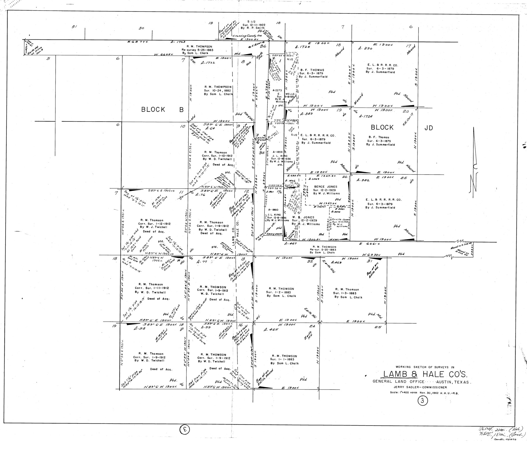
Lamb County Working Sketch 3
-
Map/Doc
70276
-
Collection
General Map Collection
-
Object Dates
11/30/1962 (Creation Date)
-
People and Organizations
Herbert H. Ulbricht (Draftsman)
Roy Buckholts (Draftsman)
-
Counties
Lamb Hale
-
Subjects
Surveying Working Sketch
-
Height x Width
32.1 x 37.7 inches
81.5 x 95.8 cm
-
Scale
1" = 400 varas
Part of: General Map Collection
Red River County Working Sketch 1

Print $20.00
- Digital $50.00
Red River County Working Sketch 1
1918
Size 26.8 x 22.1 inches
Map/Doc 71984
Stonewall County Working Sketch 35

Print $20.00
- Digital $50.00
Stonewall County Working Sketch 35
1991
Size 41.1 x 33.0 inches
Map/Doc 62342
Map of San Marcos

Print $20.00
- Digital $50.00
Map of San Marcos
1942
Size 27.4 x 21.6 inches
Map/Doc 2211
Presidio County Sketch File 101

Print $20.00
- Digital $50.00
Presidio County Sketch File 101
1888
Size 21.1 x 20.3 inches
Map/Doc 11725
Harris County Rolled Sketch 96B

Print $20.00
- Digital $50.00
Harris County Rolled Sketch 96B
Size 15.8 x 15.6 inches
Map/Doc 10681
Outer Continental Shelf Leasing Maps (Texas Offshore Operations)

Print $20.00
- Digital $50.00
Outer Continental Shelf Leasing Maps (Texas Offshore Operations)
1954
Size 20.3 x 15.5 inches
Map/Doc 75839
Anderson County Working Sketch 38

Print $20.00
- Digital $50.00
Anderson County Working Sketch 38
1985
Size 43.3 x 45.9 inches
Map/Doc 67038
Val Verde County Rolled Sketch 38

Print $20.00
- Digital $50.00
Val Verde County Rolled Sketch 38
Size 29.8 x 19.7 inches
Map/Doc 8114
Val Verde County Working Sketch 59

Print $20.00
- Digital $50.00
Val Verde County Working Sketch 59
1958
Size 38.6 x 35.0 inches
Map/Doc 72194
Flight Mission No. DAG-18K, Frame 72, Matagorda County

Print $20.00
- Digital $50.00
Flight Mission No. DAG-18K, Frame 72, Matagorda County
1952
Size 18.5 x 22.2 inches
Map/Doc 86365
Crockett County Sketch File KL

Print $20.00
- Digital $50.00
Crockett County Sketch File KL
1925
Size 30.0 x 28.7 inches
Map/Doc 11243
Flight Mission No. BQR-9K, Frame 11, Brazoria County

Print $20.00
- Digital $50.00
Flight Mission No. BQR-9K, Frame 11, Brazoria County
1952
Size 18.7 x 22.4 inches
Map/Doc 84040
You may also like
Flight Mission No. BRA-16M, Frame 61, Jefferson County

Print $20.00
- Digital $50.00
Flight Mission No. BRA-16M, Frame 61, Jefferson County
1953
Size 18.6 x 22.2 inches
Map/Doc 85678
Flight Mission No. DCL-4C, Frame 122, Kenedy County

Print $20.00
- Digital $50.00
Flight Mission No. DCL-4C, Frame 122, Kenedy County
1943
Size 18.6 x 22.3 inches
Map/Doc 85821
Williamson County Working Sketch Graphic Index

Print $40.00
- Digital $50.00
Williamson County Working Sketch Graphic Index
1946
Size 38.4 x 55.7 inches
Map/Doc 76742
Fractional Township No. 10 South Range No. 26 East of the Indian Meridian, Indian Territory

Print $20.00
- Digital $50.00
Fractional Township No. 10 South Range No. 26 East of the Indian Meridian, Indian Territory
1897
Size 19.2 x 24.3 inches
Map/Doc 75245
Vicinity of San Luis Pass, Galveston Island, Texas

Print $40.00
- Digital $50.00
Vicinity of San Luis Pass, Galveston Island, Texas
1933
Size 37.1 x 57.8 inches
Map/Doc 69943
Flight Mission No. BRE-1P, Frame 148, Nueces County

Print $20.00
- Digital $50.00
Flight Mission No. BRE-1P, Frame 148, Nueces County
1956
Size 18.6 x 22.7 inches
Map/Doc 86708
Hutson Addition to Umbarger, sec. 76, Blk. B-5, Randall Co., Texas

Print $20.00
- Digital $50.00
Hutson Addition to Umbarger, sec. 76, Blk. B-5, Randall Co., Texas
Size 30.5 x 29.5 inches
Map/Doc 92155
[T. & P. Blocks 35 and 36, Township 4 North; Block I, Township 4 North]
![91297, [T. & P. Blocks 35 and 36, Township 4 North; Block I, Township 4 North], Twichell Survey Records](https://historictexasmaps.com/wmedia_w700/maps/91297-1.tif.jpg)
Print $20.00
- Digital $50.00
[T. & P. Blocks 35 and 36, Township 4 North; Block I, Township 4 North]
Size 19.3 x 22.2 inches
Map/Doc 91297
Flight Mission No. BQY-14M, Frame 181, Harris County

Print $20.00
- Digital $50.00
Flight Mission No. BQY-14M, Frame 181, Harris County
1953
Size 18.7 x 22.2 inches
Map/Doc 85297
Parker County Working Sketch Graphic Index

Print $20.00
- Digital $50.00
Parker County Working Sketch Graphic Index
1942
Map/Doc 76661
Eastland County Working Sketch 21

Print $20.00
- Digital $50.00
Eastland County Working Sketch 21
1920
Size 15.4 x 22.7 inches
Map/Doc 68802
Sutton County Working Sketch 49

Print $20.00
- Digital $50.00
Sutton County Working Sketch 49
1955
Size 43.3 x 19.5 inches
Map/Doc 62392