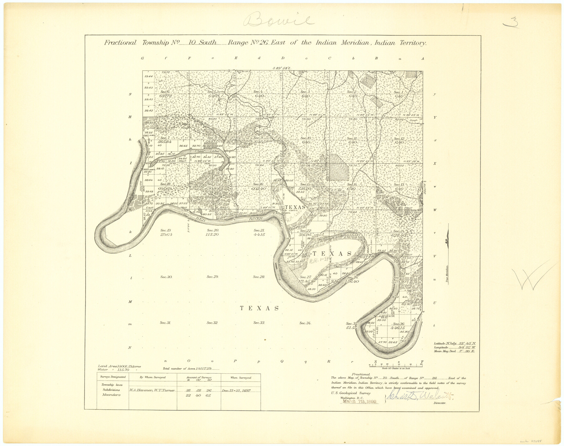
Fractional Township No. 10 South Range No. 26 East of the Indian Meridian, Indian Territory
-
Map/Doc
75245
-
Collection
General Map Collection
-
Object Dates
1897/12/21 (Creation Date)
-
Subjects
Texas Boundaries
-
Height x Width
19.2 x 24.3 inches
48.8 x 61.7 cm
Part of: General Map Collection
Jones County Boundary File 1a

Print $40.00
- Digital $50.00
Jones County Boundary File 1a
1882
Size 37.9 x 39.2 inches
Map/Doc 44358
Webb County Sketch File LM3

Print $20.00
- Digital $50.00
Webb County Sketch File LM3
1924
Size 24.7 x 31.9 inches
Map/Doc 12658
Ward County Rolled Sketch 24D

Print $40.00
- Digital $50.00
Ward County Rolled Sketch 24D
Size 45.6 x 69.0 inches
Map/Doc 10113
Flight Mission No. DQN-2K, Frame 76, Calhoun County

Print $20.00
- Digital $50.00
Flight Mission No. DQN-2K, Frame 76, Calhoun County
1953
Size 18.8 x 22.3 inches
Map/Doc 84268
Navigation Maps of Gulf Intracoastal Waterway, Port Arthur to Brownsville, Texas

Print $4.00
- Digital $50.00
Navigation Maps of Gulf Intracoastal Waterway, Port Arthur to Brownsville, Texas
1951
Size 16.7 x 21.6 inches
Map/Doc 65447
Map of Robertson County

Print $20.00
- Digital $50.00
Map of Robertson County
1873
Size 28.0 x 21.6 inches
Map/Doc 83003
Crockett County Working Sketch 78

Print $40.00
- Digital $50.00
Crockett County Working Sketch 78
1972
Size 48.3 x 36.0 inches
Map/Doc 68411
Map of the upper surveys in Robertson's Colony Sold by the State of Coahuila and Texas

Print $20.00
- Digital $50.00
Map of the upper surveys in Robertson's Colony Sold by the State of Coahuila and Texas
Size 26.8 x 22.0 inches
Map/Doc 82
San Saba County

Print $20.00
- Digital $50.00
San Saba County
1987
Size 46.3 x 42.5 inches
Map/Doc 73284
Palo Pinto County

Print $20.00
- Digital $50.00
Palo Pinto County
1879
Size 24.8 x 18.4 inches
Map/Doc 3934
[Surveys along the Leona and Frio Rivers]
![16, [Surveys along the Leona and Frio Rivers], General Map Collection](https://historictexasmaps.com/wmedia_w700/maps/16.tif.jpg)
Print $20.00
- Digital $50.00
[Surveys along the Leona and Frio Rivers]
1841
Size 12.4 x 13.1 inches
Map/Doc 16
Map of Freeport, Brazoria County, Texas

Print $20.00
- Digital $50.00
Map of Freeport, Brazoria County, Texas
Size 27.0 x 39.1 inches
Map/Doc 7689
You may also like
Clay County Boundary File 12

Print $8.00
- Digital $50.00
Clay County Boundary File 12
Size 14.3 x 8.8 inches
Map/Doc 51406
La Salle County Sketch File 42 and 42a

Print $28.00
- Digital $50.00
La Salle County Sketch File 42 and 42a
1926
Size 11.1 x 8.9 inches
Map/Doc 29597
Travis County Rolled Sketch 57

Print $20.00
- Digital $50.00
Travis County Rolled Sketch 57
1885
Size 16.5 x 23.3 inches
Map/Doc 8048
Houston County Working Sketch 33

Print $40.00
- Digital $50.00
Houston County Working Sketch 33
1987
Size 37.6 x 58.7 inches
Map/Doc 66263
Coke County Rolled Sketch 25

Print $20.00
- Digital $50.00
Coke County Rolled Sketch 25
1974
Size 24.9 x 24.3 inches
Map/Doc 5525
Cottle County Sketch File 11

Print $40.00
- Digital $50.00
Cottle County Sketch File 11
Size 12.9 x 13.3 inches
Map/Doc 19489
Tarrant County Boundary File 82

Print $22.00
- Digital $50.00
Tarrant County Boundary File 82
Size 8.9 x 7.0 inches
Map/Doc 59173
Right of Way and Track Map, the Missouri, Kansas and Texas Ry. of Texas - Henrietta Division

Print $20.00
- Digital $50.00
Right of Way and Track Map, the Missouri, Kansas and Texas Ry. of Texas - Henrietta Division
1918
Size 11.7 x 26.9 inches
Map/Doc 64749
[Surveys along the Pedernales River and Cypress Creek]
![121, [Surveys along the Pedernales River and Cypress Creek], General Map Collection](https://historictexasmaps.com/wmedia_w700/maps/121.tif.jpg)
Print $2.00
- Digital $50.00
[Surveys along the Pedernales River and Cypress Creek]
1841
Size 8.3 x 7.7 inches
Map/Doc 121
Map of Tom Green Co.

Print $40.00
- Digital $50.00
Map of Tom Green Co.
1880
Size 42.7 x 109.3 inches
Map/Doc 81917
Flight Mission No. CRE-1R, Frame 134, Jackson County

Print $20.00
- Digital $50.00
Flight Mission No. CRE-1R, Frame 134, Jackson County
1956
Size 16.2 x 16.0 inches
Map/Doc 85342
[Sketch for Mineral Application 26501 - Sabine River, T. A. Oldhausen]
![2837, [Sketch for Mineral Application 26501 - Sabine River, T. A. Oldhausen], General Map Collection](https://historictexasmaps.com/wmedia_w700/maps/2837.tif.jpg)
Print $20.00
- Digital $50.00
[Sketch for Mineral Application 26501 - Sabine River, T. A. Oldhausen]
1931
Size 24.1 x 36.0 inches
Map/Doc 2837