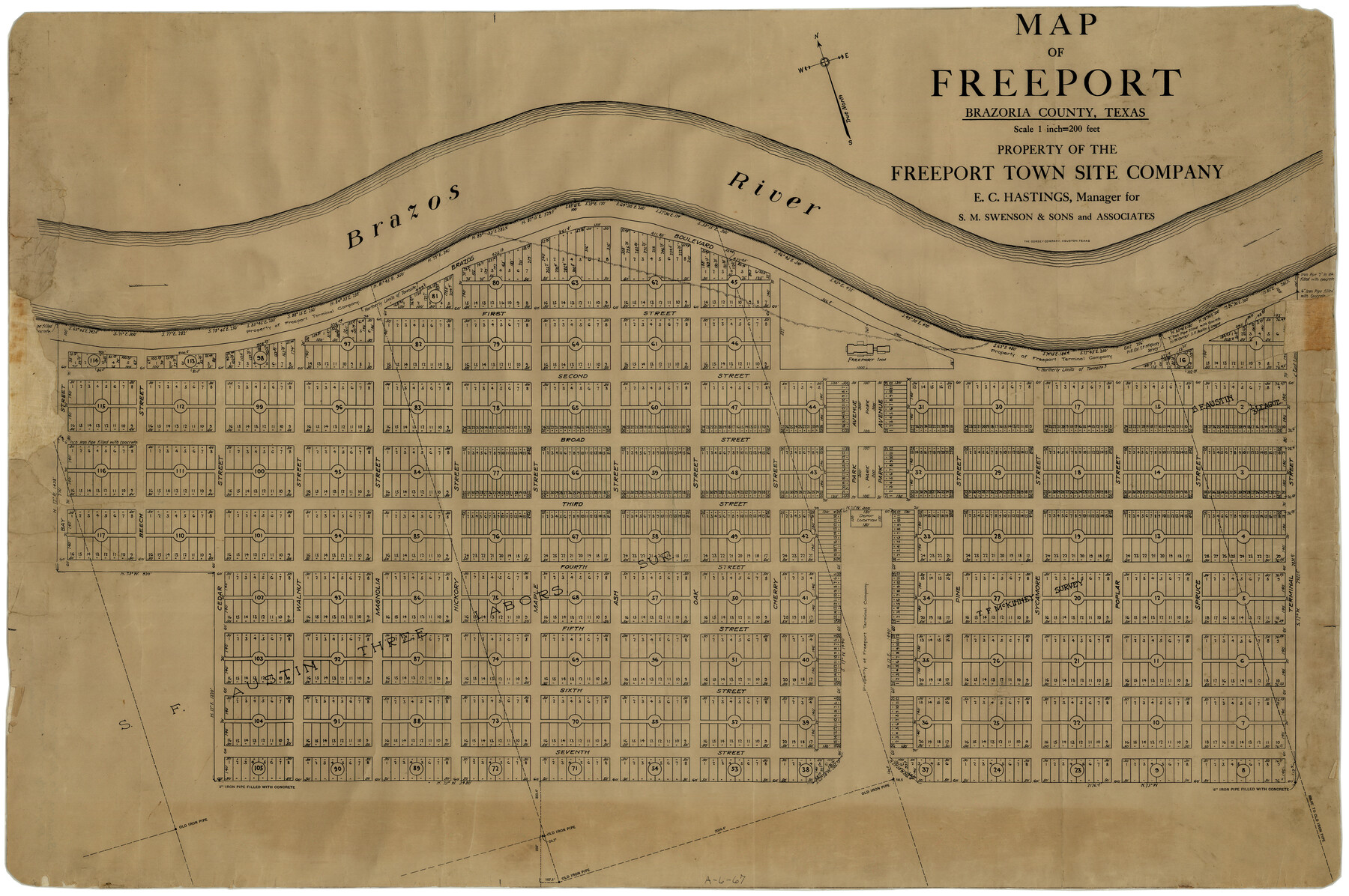
Map of Freeport, Brazoria County, Texas
Brazoria County Rolled Sketch CF, A-6-67
-
Map/Doc
7689
-
Collection
General Map Collection
-
People and Organizations
The Dorsey Company (Printer)
-
Counties
Brazoria
-
Subjects
City
-
Height x Width
27.0 x 39.1 inches
68.6 x 99.3 cm
-
Medium
paper, etching/engraving/lithograph
-
Scale
1" = 200 ft.
-
Features
Brazos River
Part of: General Map Collection
Flight Mission No. DAG-17K, Frame 136, Matagorda County

Print $20.00
- Digital $50.00
Flight Mission No. DAG-17K, Frame 136, Matagorda County
1952
Size 18.5 x 22.3 inches
Map/Doc 86353
Mitchell County Working Sketch 7

Print $20.00
- Digital $50.00
Mitchell County Working Sketch 7
1963
Size 38.6 x 22.6 inches
Map/Doc 71064
Right of Way and Track Map Texas & New Orleans R.R. Co. operated by the T. & N. O. R.R. Co. Dallas-Sabine Branch

Print $40.00
- Digital $50.00
Right of Way and Track Map Texas & New Orleans R.R. Co. operated by the T. & N. O. R.R. Co. Dallas-Sabine Branch
1918
Size 26.4 x 56.6 inches
Map/Doc 64152
Pecos County Rolled Sketch 25B

Print $20.00
- Digital $50.00
Pecos County Rolled Sketch 25B
1892
Size 22.2 x 16.0 inches
Map/Doc 7210
Shelby County Rolled Sketch 14

Print $20.00
- Digital $50.00
Shelby County Rolled Sketch 14
1948
Size 33.1 x 25.9 inches
Map/Doc 7782
Reeves County Working Sketch 61

Print $20.00
- Digital $50.00
Reeves County Working Sketch 61
1982
Size 32.1 x 31.4 inches
Map/Doc 63504
Motley County Working Sketch 2

Print $20.00
- Digital $50.00
Motley County Working Sketch 2
1895
Size 17.3 x 21.3 inches
Map/Doc 71207
El Paso County Rolled Sketch 53

Print $105.00
- Digital $50.00
El Paso County Rolled Sketch 53
1930
Size 10.1 x 15.3 inches
Map/Doc 44486
Victoria County Sketch File 9

Print $8.00
- Digital $50.00
Victoria County Sketch File 9
1938
Size 14.3 x 8.8 inches
Map/Doc 39530
Intracoastal Waterway - Galveston Bay to West Bay including Galveston Bay Entrance

Print $20.00
- Digital $50.00
Intracoastal Waterway - Galveston Bay to West Bay including Galveston Bay Entrance
1961
Size 26.7 x 38.7 inches
Map/Doc 69934
Marion County Working Sketch 46

Print $20.00
- Digital $50.00
Marion County Working Sketch 46
2011
Size 21.4 x 29.1 inches
Map/Doc 90032
Motley County Sketch File 19 (N)

Print $24.00
- Digital $50.00
Motley County Sketch File 19 (N)
1940
Size 14.2 x 8.8 inches
Map/Doc 32064
You may also like
Kaufman County Sketch File 11

Print $4.00
- Digital $50.00
Kaufman County Sketch File 11
1874
Size 10.2 x 8.4 inches
Map/Doc 28645
Flight Mission No. BRA-16M, Frame 143, Jefferson County

Print $20.00
- Digital $50.00
Flight Mission No. BRA-16M, Frame 143, Jefferson County
1953
Size 18.5 x 22.2 inches
Map/Doc 85749
Coryell County Sketch File 25

Print $4.00
- Digital $50.00
Coryell County Sketch File 25
1873
Size 12.8 x 8.3 inches
Map/Doc 19391
Leon County Rolled Sketch 6

Print $20.00
- Digital $50.00
Leon County Rolled Sketch 6
1951
Size 31.7 x 37.1 inches
Map/Doc 6596
Plat of All Surveys on the Lavaca Not Heretofor Returned

Print $2.00
- Digital $50.00
Plat of All Surveys on the Lavaca Not Heretofor Returned
1841
Size 12.5 x 7.8 inches
Map/Doc 78361
Henderson County Sketch File 1

Print $8.00
- Digital $50.00
Henderson County Sketch File 1
Size 12.8 x 8.3 inches
Map/Doc 26318
Grant and Beales Empresario Colony. October 9, 1832

Print $20.00
Grant and Beales Empresario Colony. October 9, 1832
2020
Size 23.5 x 21.7 inches
Map/Doc 95996
[G. H. & H. Block 2]
![90714, [G. H. & H. Block 2], Twichell Survey Records](https://historictexasmaps.com/wmedia_w700/maps/90714-1.tif.jpg)
Print $20.00
- Digital $50.00
[G. H. & H. Block 2]
Size 24.1 x 18.5 inches
Map/Doc 90714
Flight Mission No. DQN-7K, Frame 88, Calhoun County

Print $20.00
- Digital $50.00
Flight Mission No. DQN-7K, Frame 88, Calhoun County
1953
Size 18.5 x 22.1 inches
Map/Doc 84479
Newton County Sketch File 43

Print $12.00
- Digital $50.00
Newton County Sketch File 43
1944
Size 11.2 x 8.6 inches
Map/Doc 32435
Map of Mexico, including Yucatan & Upper California, exhibiting the chief cities and towns, the principal travelling routes &c.

Print $20.00
- Digital $50.00
Map of Mexico, including Yucatan & Upper California, exhibiting the chief cities and towns, the principal travelling routes &c.
1847
Size 33.5 x 24.7 inches
Map/Doc 93936
Hutchinson County Rolled Sketch 4

Print $20.00
- Digital $50.00
Hutchinson County Rolled Sketch 4
Size 21.3 x 30.1 inches
Map/Doc 6277