Henderson County Sketch File 1
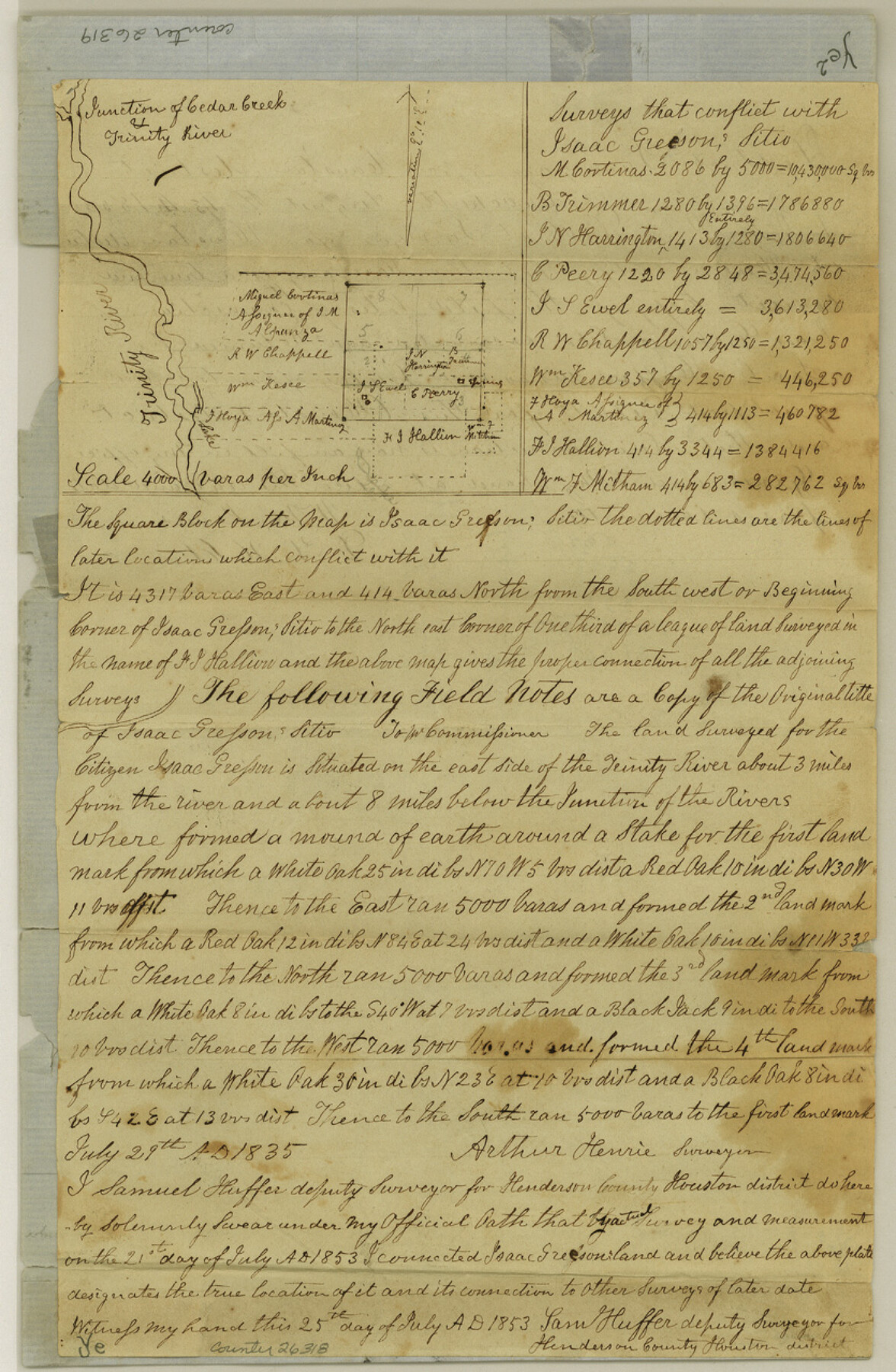
[Sketch and field notes of Isaac Greeson survey]
-
Map/Doc
26318
-
Collection
General Map Collection
-
Object Dates
6/28/1855 (File Date)
7/29/1835 (Survey Date)
7/21/1853 (Survey Date)
8/13/1853 (Correspondence Date)
7/16/1852 (File Date)
-
People and Organizations
W.M. James (Surveyor/Engineer)
Arthur Henrie (Surveyor/Engineer)
Samuel Huffer (Surveyor/Engineer)
-
Counties
Henderson
-
Subjects
Surveying Sketch File
-
Height x Width
12.8 x 8.3 inches
32.5 x 21.1 cm
-
Medium
paper, manuscript
-
Scale
1:4000
-
Features
Trinity River
Cedar Creek
Part of: General Map Collection
Sutton County Sketch File Ca

Print $6.00
- Digital $50.00
Sutton County Sketch File Ca
1901
Size 12.3 x 9.8 inches
Map/Doc 37382
[Capitol League Surveys in Hartley County, Texas]
![1766, [Capitol League Surveys in Hartley County, Texas], General Map Collection](https://historictexasmaps.com/wmedia_w700/maps/1766.tif.jpg)
Print $20.00
- Digital $50.00
[Capitol League Surveys in Hartley County, Texas]
1910
Size 19.6 x 27.9 inches
Map/Doc 1766
Swisher County Sketch File 9

Print $4.00
- Digital $50.00
Swisher County Sketch File 9
1916
Size 11.2 x 8.7 inches
Map/Doc 37629
Uvalde County Working Sketch 44

Print $20.00
- Digital $50.00
Uvalde County Working Sketch 44
1978
Size 27.6 x 32.7 inches
Map/Doc 72114
Schleicher County Sketch File 46

Print $4.00
- Digital $50.00
Schleicher County Sketch File 46
1958
Size 3.7 x 8.8 inches
Map/Doc 36554
Webb County Boundary File 7

Print $98.00
- Digital $50.00
Webb County Boundary File 7
Size 14.2 x 8.7 inches
Map/Doc 59809
Flight Mission No. BRA-17M, Frame 14, Jefferson County

Print $20.00
- Digital $50.00
Flight Mission No. BRA-17M, Frame 14, Jefferson County
1953
Size 18.5 x 22.3 inches
Map/Doc 85795
Morris County Rolled Sketch 2A

Print $20.00
- Digital $50.00
Morris County Rolled Sketch 2A
Size 36.7 x 25.1 inches
Map/Doc 10259
Map of Oceania engraved to illustrate Mitchell's school and family geography

Print $20.00
- Digital $50.00
Map of Oceania engraved to illustrate Mitchell's school and family geography
1839
Size 9.5 x 11.8 inches
Map/Doc 93508
Shelby County Working Sketch 14

Print $20.00
- Digital $50.00
Shelby County Working Sketch 14
1948
Size 28.5 x 22.3 inches
Map/Doc 63867
San Jacinto Co.

Print $20.00
- Digital $50.00
San Jacinto Co.
1889
Size 46.4 x 37.9 inches
Map/Doc 63016
Padre Island National Seashore

Print $4.00
- Digital $50.00
Padre Island National Seashore
Size 16.1 x 22.3 inches
Map/Doc 60535
You may also like
Edwards County Boundary File 27c

Print $29.00
- Digital $50.00
Edwards County Boundary File 27c
Size 12.8 x 8.1 inches
Map/Doc 52896
[Sections 69-84 Block 47 and part of Block 3]
![91795, [Sections 69-84 Block 47 and part of Block 3], Twichell Survey Records](https://historictexasmaps.com/wmedia_w700/maps/91795-1.tif.jpg)
Print $2.00
- Digital $50.00
[Sections 69-84 Block 47 and part of Block 3]
Size 14.3 x 8.9 inches
Map/Doc 91795
Floyd County Working Sketch 9

Print $20.00
- Digital $50.00
Floyd County Working Sketch 9
1952
Size 31.5 x 35.9 inches
Map/Doc 69188
[Blocks D, DD Showing Terrain]
![92445, [Blocks D, DD Showing Terrain], Twichell Survey Records](https://historictexasmaps.com/wmedia_w700/maps/92445-1.tif.jpg)
Print $20.00
- Digital $50.00
[Blocks D, DD Showing Terrain]
Size 30.8 x 17.2 inches
Map/Doc 92445
Blanco County Sketch File 48

Print $6.00
- Digital $50.00
Blanco County Sketch File 48
1952
Size 11.7 x 9.0 inches
Map/Doc 14688
Aransas County Boundary File 8

Print $135.00
- Digital $50.00
Aransas County Boundary File 8
Size 33.6 x 74.0 inches
Map/Doc 50043
Map of Limestone County

Print $20.00
- Digital $50.00
Map of Limestone County
1869
Size 22.1 x 22.4 inches
Map/Doc 3818
Montgomery County Rolled Sketch 47

Print $20.00
- Digital $50.00
Montgomery County Rolled Sketch 47
2009
Size 36.5 x 24.6 inches
Map/Doc 89032
Terrell County Sketch File 36

Print $40.00
- Digital $50.00
Terrell County Sketch File 36
1958
Size 15.7 x 13.5 inches
Map/Doc 37998
Outer Continental Shelf Leasing Maps (Louisiana Offshore Operations)

Print $20.00
- Digital $50.00
Outer Continental Shelf Leasing Maps (Louisiana Offshore Operations)
1954
Size 15.8 x 10.0 inches
Map/Doc 76109
Crane County Rolled Sketch 17

Print $20.00
- Digital $50.00
Crane County Rolled Sketch 17
1926
Size 20.3 x 33.8 inches
Map/Doc 5576
[Leagues 53 through 57]
![92483, [Leagues 53 through 57], Twichell Survey Records](https://historictexasmaps.com/wmedia_w700/maps/92483-1.tif.jpg)
Print $20.00
- Digital $50.00
[Leagues 53 through 57]
1913
Size 17.8 x 19.0 inches
Map/Doc 92483