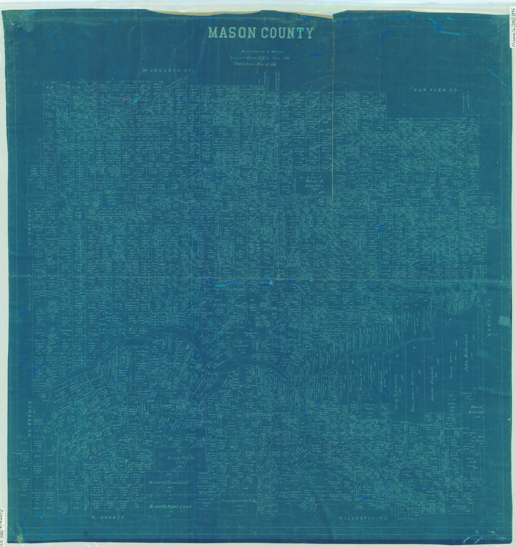
Mason County
-
Map/Doc
78416
-
Collection
General Map Collection
-
Object Dates
1896 (Creation Date)
-
People and Organizations
Texas General Land Office (Publisher)
-
Counties
Mason
-
Subjects
County
-
Height x Width
39.0 x 36.8 inches
99.1 x 93.5 cm
-
Comments
Note on map: "Traced from Map of 1886. This blueprint made May 1902 from tracing of 1896".
-
Features
Llano River
Squaw Creek
Panther Creek
Blue Mountains
Leone Creek
Comanche Creek
Fort Mason
Mason
West Fork of Llano River
Camp Creek
Middle Fork of Llano River
Honey Creek
Willow Creek
Hackberry Creek
Tiger Creek
Grape Creek
Katenesy [sic] Creek
San Saba River
Part of: General Map Collection
[Surveys in Power and Hewetson's Colony along the San Antonio and Guadalupe Rivers]
![23, [Surveys in Power and Hewetson's Colony along the San Antonio and Guadalupe Rivers], General Map Collection](https://historictexasmaps.com/wmedia_w700/maps/23.tif.jpg)
Print $20.00
- Digital $50.00
[Surveys in Power and Hewetson's Colony along the San Antonio and Guadalupe Rivers]
1837
Size 14.9 x 16.5 inches
Map/Doc 23
Flight Mission No. BRE-1P, Frame 46, Nueces County

Print $20.00
- Digital $50.00
Flight Mission No. BRE-1P, Frame 46, Nueces County
1956
Size 16.4 x 16.2 inches
Map/Doc 86635
Foard County Boundary File 5a

Print $40.00
- Digital $50.00
Foard County Boundary File 5a
Size 18.2 x 44.4 inches
Map/Doc 53546
Hutchinson County Rolled Sketch 44-11

Print $20.00
- Digital $50.00
Hutchinson County Rolled Sketch 44-11
2002
Size 24.0 x 36.0 inches
Map/Doc 77547
Chambers County Working Sketch 20

Print $20.00
- Digital $50.00
Chambers County Working Sketch 20
1973
Size 25.8 x 30.2 inches
Map/Doc 68003
Wise County Sketch File 47

Print $4.00
- Digital $50.00
Wise County Sketch File 47
1888
Size 8.8 x 12.8 inches
Map/Doc 40607
Hudspeth County Sketch File 13

Print $18.00
- Digital $50.00
Hudspeth County Sketch File 13
1915
Size 13.3 x 8.9 inches
Map/Doc 26929
Dawson County Rolled Sketch 14

Print $20.00
- Digital $50.00
Dawson County Rolled Sketch 14
1989
Size 22.6 x 35.7 inches
Map/Doc 5697
Presidio County Sketch File R

Print $18.00
- Digital $50.00
Presidio County Sketch File R
Size 10.3 x 8.4 inches
Map/Doc 34590
Pecos County Working Sketch 65

Print $20.00
- Digital $50.00
Pecos County Working Sketch 65
1955
Size 25.0 x 19.4 inches
Map/Doc 71537
Terrell County Rolled Sketch 45

Print $40.00
- Digital $50.00
Terrell County Rolled Sketch 45
1953
Size 33.5 x 51.7 inches
Map/Doc 9991
Copy of a chart of Aransas and Corpus Christi Bays by an inhabitant of St. Joseph's Island, the main features of which have been verified by the examinations of Capt. Crosman and other officers of the army

Print $20.00
- Digital $50.00
Copy of a chart of Aransas and Corpus Christi Bays by an inhabitant of St. Joseph's Island, the main features of which have been verified by the examinations of Capt. Crosman and other officers of the army
1845
Size 26.4 x 18.5 inches
Map/Doc 73013
You may also like
McLennan County Sketch File 43

Print $4.00
- Digital $50.00
McLennan County Sketch File 43
1873
Size 10.0 x 8.1 inches
Map/Doc 31333
Culberson County Working Sketch Graphic Index, Sheet A (Sketches 1 to 40)

Print $40.00
- Digital $50.00
Culberson County Working Sketch Graphic Index, Sheet A (Sketches 1 to 40)
1943
Size 51.6 x 32.7 inches
Map/Doc 76514
Bee County Sketch File 13

Print $4.00
- Digital $50.00
Bee County Sketch File 13
1876
Size 12.6 x 8.1 inches
Map/Doc 14295
Mills County Working Sketch 18

Print $20.00
- Digital $50.00
Mills County Working Sketch 18
1963
Size 23.2 x 37.0 inches
Map/Doc 71048
Stonewall County Working Sketch 26

Print $20.00
- Digital $50.00
Stonewall County Working Sketch 26
1973
Size 27.0 x 17.9 inches
Map/Doc 62333
Winkler County Sketch File 10

Print $4.00
- Digital $50.00
Winkler County Sketch File 10
1910
Size 9.1 x 8.3 inches
Map/Doc 40486
Flight Mission No. BRA-16M, Frame 140, Jefferson County

Print $20.00
- Digital $50.00
Flight Mission No. BRA-16M, Frame 140, Jefferson County
1953
Size 18.6 x 22.2 inches
Map/Doc 85746
Lamar County Boundary File 56a

Print $34.00
- Digital $50.00
Lamar County Boundary File 56a
Size 8.7 x 14.3 inches
Map/Doc 56020
Brewster County Working Sketch 34

Print $20.00
- Digital $50.00
Brewster County Working Sketch 34
1943
Size 33.7 x 21.2 inches
Map/Doc 67568
Henderson County

Print $20.00
- Digital $50.00
Henderson County
1856
Size 17.9 x 29.2 inches
Map/Doc 3664
Flight Mission No. BRA-8M, Frame 117, Jefferson County

Print $20.00
- Digital $50.00
Flight Mission No. BRA-8M, Frame 117, Jefferson County
1953
Size 18.5 x 22.3 inches
Map/Doc 85613
[Worksheets related to the Wilson Strickland survey and vicinity]
![91266, [Vicinity and related to the Wilson Strickland Survey], Twichell Survey Records](https://historictexasmaps.com/wmedia_w700/maps/91266-1.tif.jpg)
Print $20.00
- Digital $50.00
[Worksheets related to the Wilson Strickland survey and vicinity]
Size 35.8 x 17.5 inches
Map/Doc 91266