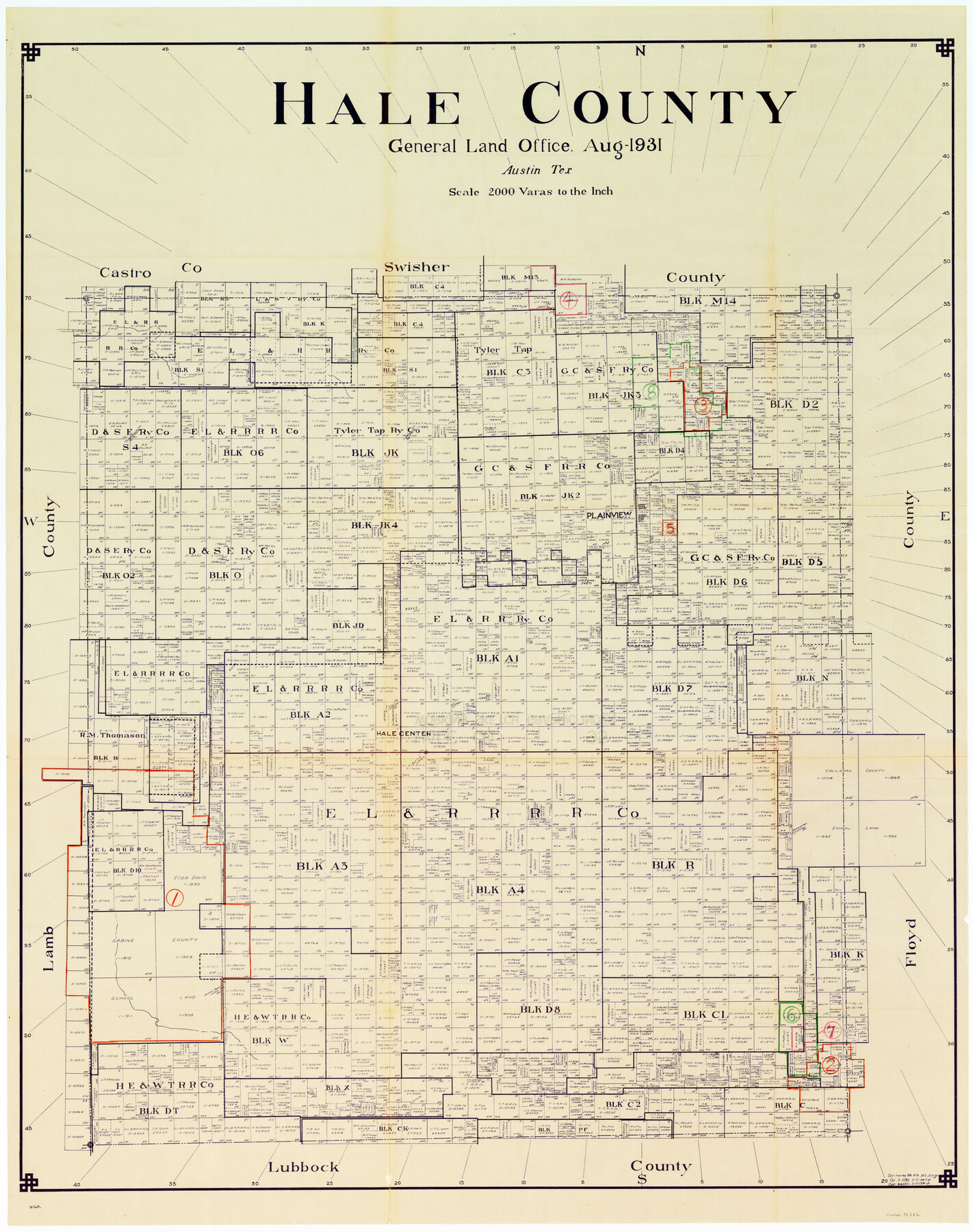
Hale County Working Sketch Graphic Index
-
Map/Doc
76562
-
Collection
General Map Collection
-
Object Dates
8/1931 (Creation Date)
-
Counties
Hale
-
Subjects
County Surveying Working Sketch
-
Height x Width
46.4 x 36.9 inches
117.9 x 93.7 cm
-
Scale
1" = 2000 varas
Part of: General Map Collection
Right of Way and Track Map, the Missouri, Kansas and Texas Ry. of Texas operated by the Missouri, Kansas and Texas Ry. of Texas, San Antonio Division

Print $40.00
- Digital $50.00
Right of Way and Track Map, the Missouri, Kansas and Texas Ry. of Texas operated by the Missouri, Kansas and Texas Ry. of Texas, San Antonio Division
1918
Size 25.2 x 58.8 inches
Map/Doc 64584
Map of Texas and Pacific Ry. Company's Surveys in the 80 Mile Reserve

Print $40.00
- Digital $50.00
Map of Texas and Pacific Ry. Company's Surveys in the 80 Mile Reserve
1885
Size 41.5 x 91.8 inches
Map/Doc 60313
Flight Mission No. DAG-21K, Frame 37, Matagorda County

Print $20.00
- Digital $50.00
Flight Mission No. DAG-21K, Frame 37, Matagorda County
1952
Size 18.5 x 22.4 inches
Map/Doc 86404
Grimes County Working Sketch 5

Print $40.00
- Digital $50.00
Grimes County Working Sketch 5
1949
Size 43.6 x 83.2 inches
Map/Doc 63296
Orange County Rolled Sketch 18

Print $20.00
- Digital $50.00
Orange County Rolled Sketch 18
Size 11.6 x 12.6 inches
Map/Doc 7182
Jasper County Working Sketch 15

Print $20.00
- Digital $50.00
Jasper County Working Sketch 15
1925
Size 26.8 x 22.1 inches
Map/Doc 66477
Bell County Working Sketch 3

Print $3.00
- Digital $50.00
Bell County Working Sketch 3
1940
Size 10.8 x 12.8 inches
Map/Doc 67343
Pecos County Sketch File 34

Print $4.00
- Digital $50.00
Pecos County Sketch File 34
Size 11.1 x 8.5 inches
Map/Doc 33714
Wichita County Working Sketch 3

Print $20.00
- Digital $50.00
Wichita County Working Sketch 3
1913
Size 22.2 x 15.6 inches
Map/Doc 72512
Sketch showing progress of topographical work Laguna Madre and vicinity from Rainey Is. to Baffins Bay, Coast of Texas Sect. IX [and accompanying letter]
![72958, Sketch showing progress of topographical work Laguna Madre and vicinity from Rainey Is. to Baffins Bay, Coast of Texas Sect. IX [and accompanying letter], General Map Collection](https://historictexasmaps.com/wmedia_w700/maps/72958.tif.jpg)
Print $2.00
- Digital $50.00
Sketch showing progress of topographical work Laguna Madre and vicinity from Rainey Is. to Baffins Bay, Coast of Texas Sect. IX [and accompanying letter]
1881
Size 11.2 x 8.8 inches
Map/Doc 72958


You may also like

Sterling County Rolled Sketch 34

Print $20.00
- Digital $50.00
Sterling County Rolled Sketch 34
1960
Size 16.0 x 21.8 inches
Map/Doc 7858
Upton County Sketch File 42

Print $3.00
- Digital $50.00
Upton County Sketch File 42
1986
Size 10.9 x 17.0 inches
Map/Doc 38919
Hardeman Co[unty]
![16845, Hardeman Co[unty], General Map Collection](https://historictexasmaps.com/wmedia_w700/maps/16845.tif.jpg)
Print $40.00
- Digital $50.00
Hardeman Co[unty]
1886
Size 60.7 x 48.8 inches
Map/Doc 16845
[Sketch for Mineral Application 24072, San Jacinto River]
![65609, [Sketch for Mineral Application 24072, San Jacinto River], General Map Collection](https://historictexasmaps.com/wmedia_w700/maps/65609.tif.jpg)
Print $20.00
- Digital $50.00
[Sketch for Mineral Application 24072, San Jacinto River]
1929
Size 8.4 x 13.9 inches
Map/Doc 65609
Roberts County Working Sketch 18

Print $20.00
- Digital $50.00
Roberts County Working Sketch 18
1975
Size 35.6 x 39.7 inches
Map/Doc 63544
La Salle County Sketch File 38

Print $40.00
- Digital $50.00
La Salle County Sketch File 38
Size 13.7 x 14.5 inches
Map/Doc 29590
[Midland County School Land, Martin County School Land, and vicinity]
![91128, [Midland County School Land, Martin County School Land, and vicinity], Twichell Survey Records](https://historictexasmaps.com/wmedia_w700/maps/91128-1.tif.jpg)
Print $2.00
- Digital $50.00
[Midland County School Land, Martin County School Land, and vicinity]
Size 9.0 x 11.4 inches
Map/Doc 91128
[Sketch for Mineral Application 12206 - Cow Bayou, O. B. Sawyer]
![65568, [Sketch for Mineral Application 12206 - Cow Bayou, O. B. Sawyer], General Map Collection](https://historictexasmaps.com/wmedia_w700/maps/65568.tif.jpg)
Print $40.00
- Digital $50.00
[Sketch for Mineral Application 12206 - Cow Bayou, O. B. Sawyer]
Size 37.4 x 140.2 inches
Map/Doc 65568
Brown County Sketch File 26

Print $40.00
- Digital $50.00
Brown County Sketch File 26
Size 18.4 x 24.4 inches
Map/Doc 11023
Webb County Working Sketch Graphic Index - northeast part

Print $20.00
- Digital $50.00
Webb County Working Sketch Graphic Index - northeast part
1986
Size 35.7 x 47.1 inches
Map/Doc 76734
Brazoria County NRC Article 33.136 Sketch 32

Print $24.00
Brazoria County NRC Article 33.136 Sketch 32
2025
Map/Doc 97490