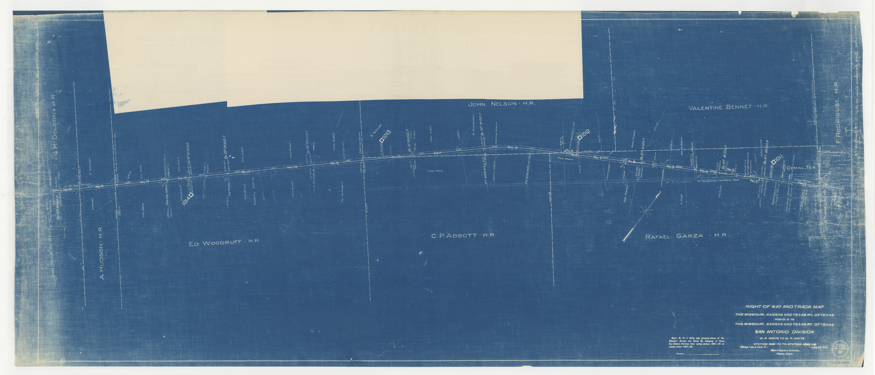
Right of Way and Track Map, the Missouri, Kansas and Texas Ry. of Texas operated by the Missouri, Kansas and Texas Ry. of Texas, San Antonio Division
M.P. 1010.75 to M.P. 1014.73, Station 4051+70 to Station 4262+05
Z-2-180
-
Map/Doc
64584
-
Collection
General Map Collection
-
Object Dates
1918/6/30 (Creation Date)
-
Counties
Bexar Hays Comal
-
Subjects
Railroads
-
Height x Width
25.2 x 58.8 inches
64.0 x 149.4 cm
-
Medium
blueprint/diazo
-
Scale
1" = 400 feet
-
Comments
See image numbers 64579 through 64583 for other sheets of the map.
-
Features
MK&T
Old Nacogdoches to San Antonio Road
Old Nacogdoches Road
San Antonio Road
Comal
Part of: General Map Collection
Sutton County Working Sketch 35

Print $20.00
- Digital $50.00
Sutton County Working Sketch 35
1939
Size 35.0 x 14.3 inches
Map/Doc 62378
Wichita County Sketch File 6

Print $40.00
- Digital $50.00
Wichita County Sketch File 6
Size 12.3 x 12.2 inches
Map/Doc 40045
El Paso County Working Sketch 54

Print $20.00
- Digital $50.00
El Paso County Working Sketch 54
1992
Size 31.5 x 29.0 inches
Map/Doc 69076
Kleberg County Aerial Photograph Index Sheet 2

Print $20.00
- Digital $50.00
Kleberg County Aerial Photograph Index Sheet 2
1956
Size 19.4 x 23.4 inches
Map/Doc 83719
Fractional Township No. 7 South Range No. 15 East of the Indian Meridian, Indian Territory

Print $20.00
- Digital $50.00
Fractional Township No. 7 South Range No. 15 East of the Indian Meridian, Indian Territory
1896
Size 19.2 x 24.3 inches
Map/Doc 75226
Map of the Mexican National R.R. "Laredo Route" and Connections. The Scenic Short Line to the City of Mexico

Print $20.00
- Digital $50.00
Map of the Mexican National R.R. "Laredo Route" and Connections. The Scenic Short Line to the City of Mexico
1901
Size 24.2 x 24.3 inches
Map/Doc 95145
Tarrant County Sketch File 1a

Print $4.00
- Digital $50.00
Tarrant County Sketch File 1a
1851
Size 10.2 x 7.8 inches
Map/Doc 37670
Map of Roberts County

Print $40.00
- Digital $50.00
Map of Roberts County
1900
Size 45.3 x 50.0 inches
Map/Doc 3990
Wharton County

Print $40.00
- Digital $50.00
Wharton County
1946
Size 43.1 x 49.7 inches
Map/Doc 95671
Flight Mission No. DQO-3K, Frame 20, Galveston County

Print $20.00
- Digital $50.00
Flight Mission No. DQO-3K, Frame 20, Galveston County
1952
Size 18.8 x 22.6 inches
Map/Doc 85061
Map of Parker County

Print $20.00
- Digital $50.00
Map of Parker County
1860
Size 24.1 x 19.0 inches
Map/Doc 3945
Brooks County Sketch File 4

Print $4.00
- Digital $50.00
Brooks County Sketch File 4
Size 14.3 x 8.7 inches
Map/Doc 16549
You may also like
[Sketch of a portion of Hutchinson County, Texas]
![413, [Sketch of a portion of Hutchinson County, Texas], Maddox Collection](https://historictexasmaps.com/wmedia_w700/maps/0413.tif.jpg)
Print $20.00
- Digital $50.00
[Sketch of a portion of Hutchinson County, Texas]
1889
Size 14.9 x 17.3 inches
Map/Doc 413
Borden County Sketch File 12

Print $24.00
- Digital $50.00
Borden County Sketch File 12
Size 10.8 x 9.1 inches
Map/Doc 14732
Menard County Sketch File 30

Print $4.00
- Digital $50.00
Menard County Sketch File 30
1977
Size 14.3 x 8.6 inches
Map/Doc 31571
Potter County

Print $20.00
- Digital $50.00
Potter County
1960
Size 40.0 x 32.3 inches
Map/Doc 77397
Flight Mission No. DCL-7C, Frame 38, Kenedy County

Print $20.00
- Digital $50.00
Flight Mission No. DCL-7C, Frame 38, Kenedy County
1943
Size 15.4 x 15.1 inches
Map/Doc 86026
Henderson County Rolled Sketch 11

Print $20.00
- Digital $50.00
Henderson County Rolled Sketch 11
1915
Size 29.3 x 42.6 inches
Map/Doc 75952
Schleicher County Sketch File 38

Print $20.00
- Digital $50.00
Schleicher County Sketch File 38
Size 19.1 x 21.7 inches
Map/Doc 12311
Montgomery County Boundary File 2

Print $6.00
- Digital $50.00
Montgomery County Boundary File 2
Size 17.1 x 11.4 inches
Map/Doc 57448
Edwards County Working Sketch 123

Print $20.00
- Digital $50.00
Edwards County Working Sketch 123
1976
Size 18.3 x 25.2 inches
Map/Doc 68999
Hamilton County Working Sketch 21

Print $40.00
- Digital $50.00
Hamilton County Working Sketch 21
1955
Size 52.4 x 43.7 inches
Map/Doc 63359
Motley County

Print $20.00
- Digital $50.00
Motley County
1914
Size 47.0 x 37.7 inches
Map/Doc 66946
Coast Chart No. 210 Aransas Pass and Corpus Christi Bay with the coast to latitude 27° 12' Texas

Print $20.00
- Digital $50.00
Coast Chart No. 210 Aransas Pass and Corpus Christi Bay with the coast to latitude 27° 12' Texas
1887
Size 26.7 x 18.3 inches
Map/Doc 72810