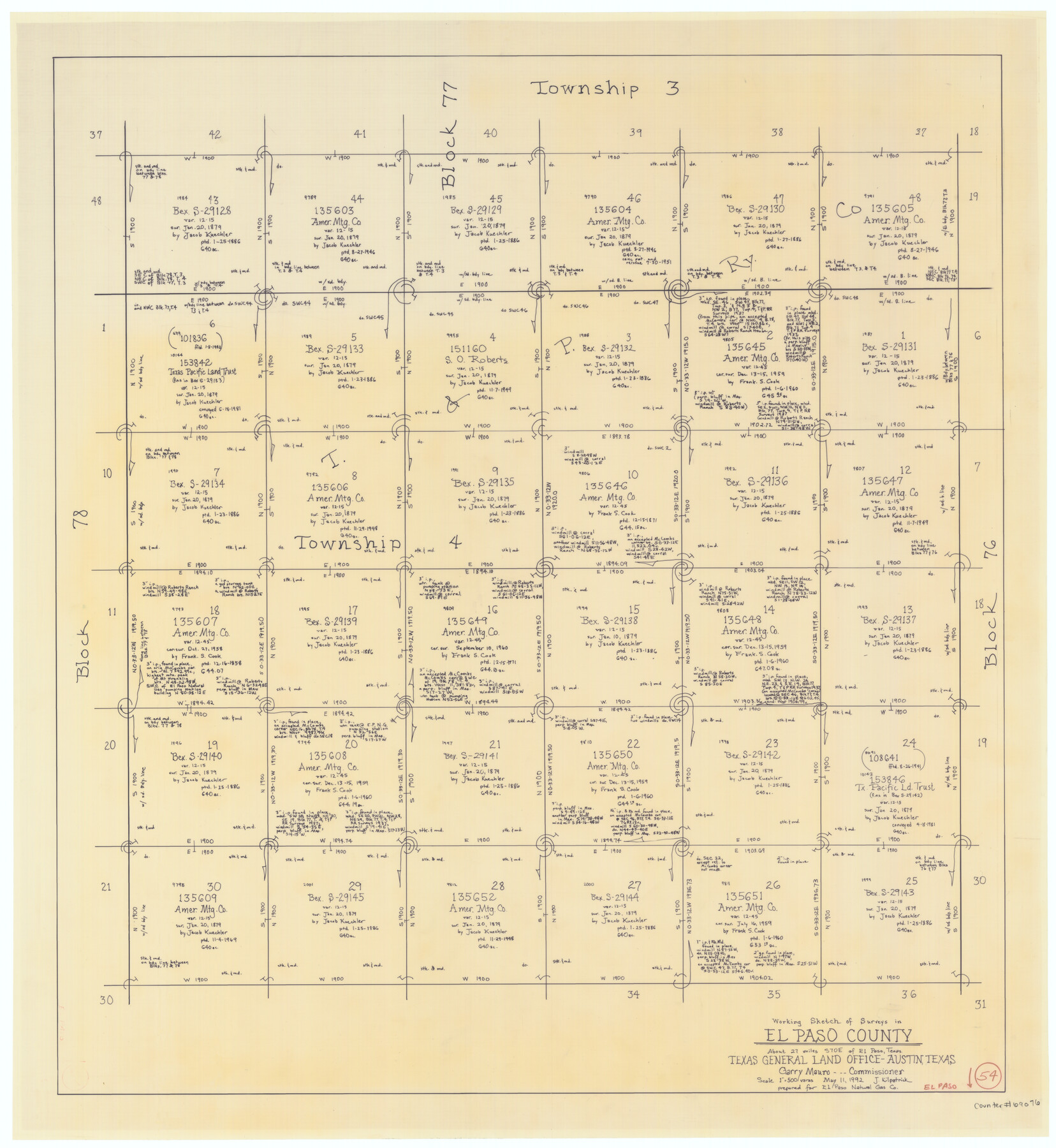
El Paso County Working Sketch 54
-
Map/Doc
69076
-
Collection
General Map Collection
-
Object Dates
5/11/1992 (Creation Date)
-
People and Organizations
Joan Kilpatrick (Draftsman)
-
Counties
El Paso
-
Subjects
Surveying Working Sketch
-
Height x Width
31.5 x 29.0 inches
80.0 x 73.7 cm
-
Scale
1" = 500 varas
Part of: General Map Collection
Flight Mission No. BQR-22K, Frame 34, Brazoria County

Print $20.00
- Digital $50.00
Flight Mission No. BQR-22K, Frame 34, Brazoria County
1953
Size 18.7 x 22.5 inches
Map/Doc 84118
Flight Mission No. DQO-3K, Frame 31, Galveston County

Print $20.00
- Digital $50.00
Flight Mission No. DQO-3K, Frame 31, Galveston County
1952
Size 18.9 x 22.5 inches
Map/Doc 85072
Coryell County

Print $20.00
- Digital $50.00
Coryell County
1936
Size 44.5 x 41.2 inches
Map/Doc 73117
Railroad Track Map, H&TCRRCo., Falls County, Texas

Print $4.00
- Digital $50.00
Railroad Track Map, H&TCRRCo., Falls County, Texas
1918
Size 11.8 x 18.4 inches
Map/Doc 62838
Hunt County Boundary File 2b

Print $2.00
- Digital $50.00
Hunt County Boundary File 2b
Size 12.8 x 7.9 inches
Map/Doc 55207
Map of Africa engraved to illustrate Mitchell's new intermediate geography (Inset 1: Map of Egypt / Inset 2: Liberia and Sierra Leone)

Print $20.00
- Digital $50.00
Map of Africa engraved to illustrate Mitchell's new intermediate geography (Inset 1: Map of Egypt / Inset 2: Liberia and Sierra Leone)
1885
Size 9.0 x 12.2 inches
Map/Doc 93530
Flight Mission No. DQO-8K, Frame 48, Galveston County

Print $20.00
- Digital $50.00
Flight Mission No. DQO-8K, Frame 48, Galveston County
1952
Size 18.7 x 22.2 inches
Map/Doc 85155
Old Miscellaneous File 4

Print $22.00
- Digital $50.00
Old Miscellaneous File 4
1845
Size 16.5 x 20.8 inches
Map/Doc 75416
Flight Mission No. DAG-23K, Frame 187, Matagorda County

Print $20.00
- Digital $50.00
Flight Mission No. DAG-23K, Frame 187, Matagorda County
1953
Size 17.5 x 22.4 inches
Map/Doc 86522
Map of South America engraved to illustrate Mitchell's new intermediate geography

Print $20.00
- Digital $50.00
Map of South America engraved to illustrate Mitchell's new intermediate geography
1885
Size 12.2 x 9.0 inches
Map/Doc 93525
Cuadro Historico-Geroglifico de la Peregrinacion de las Tribus Aztecas que Poblaron el Valle de Mexico (Num. 2)

Print $20.00
- Digital $50.00
Cuadro Historico-Geroglifico de la Peregrinacion de las Tribus Aztecas que Poblaron el Valle de Mexico (Num. 2)
Size 22.9 x 31.3 inches
Map/Doc 97012
Concho County Working Sketch 3

Print $20.00
- Digital $50.00
Concho County Working Sketch 3
1918
Size 24.0 x 22.2 inches
Map/Doc 68185
You may also like
[Reverse of] Plan of the City of Austin
![76228, [Reverse of] Plan of the City of Austin, Texas State Library and Archives](https://historictexasmaps.com/wmedia_w700/maps/76228.tif.jpg)
Print $20.00
[Reverse of] Plan of the City of Austin
1839
Size 19.2 x 24.3 inches
Map/Doc 76228
Flight Mission No. BRE-1P, Frame 151, Nueces County

Print $20.00
- Digital $50.00
Flight Mission No. BRE-1P, Frame 151, Nueces County
1956
Size 18.7 x 22.5 inches
Map/Doc 86711
Presidio County Rolled Sketch 113

Print $20.00
- Digital $50.00
Presidio County Rolled Sketch 113
1978
Size 22.2 x 27.8 inches
Map/Doc 7389
Brazos River, Ft. Griffin State Park/Mill Cr.-Clear Fork of Brazos River

Print $4.00
- Digital $50.00
Brazos River, Ft. Griffin State Park/Mill Cr.-Clear Fork of Brazos River
1940
Size 27.5 x 20.5 inches
Map/Doc 65291
Outer Continental Shelf Leasing Maps (Texas Offshore Operations)

Print $20.00
- Digital $50.00
Outer Continental Shelf Leasing Maps (Texas Offshore Operations)
1954
Size 14.6 x 15.6 inches
Map/Doc 75836
Brewster County Rolled Sketch 23

Print $20.00
- Digital $50.00
Brewster County Rolled Sketch 23
Size 24.5 x 24.8 inches
Map/Doc 5207
Cameron County Rolled Sketch 11A

Print $20.00
- Digital $50.00
Cameron County Rolled Sketch 11A
1934
Size 30.0 x 37.0 inches
Map/Doc 11048
Map of Newton County, Texas

Print $20.00
- Digital $50.00
Map of Newton County, Texas
1893
Size 35.0 x 15.2 inches
Map/Doc 587
Aransas County Sketch File 12a

Print $8.00
- Digital $50.00
Aransas County Sketch File 12a
1889
Size 14.1 x 8.8 inches
Map/Doc 13122
Shelby County Sketch File 31

Print $20.00
- Digital $50.00
Shelby County Sketch File 31
1949
Size 12.0 x 36.0 inches
Map/Doc 12320
Concho County Working Sketch 18

Print $20.00
- Digital $50.00
Concho County Working Sketch 18
1957
Size 19.2 x 25.2 inches
Map/Doc 68200
Flight Mission No. DCL-6C, Frame 128, Kenedy County

Print $20.00
- Digital $50.00
Flight Mission No. DCL-6C, Frame 128, Kenedy County
1943
Size 18.6 x 22.3 inches
Map/Doc 85958