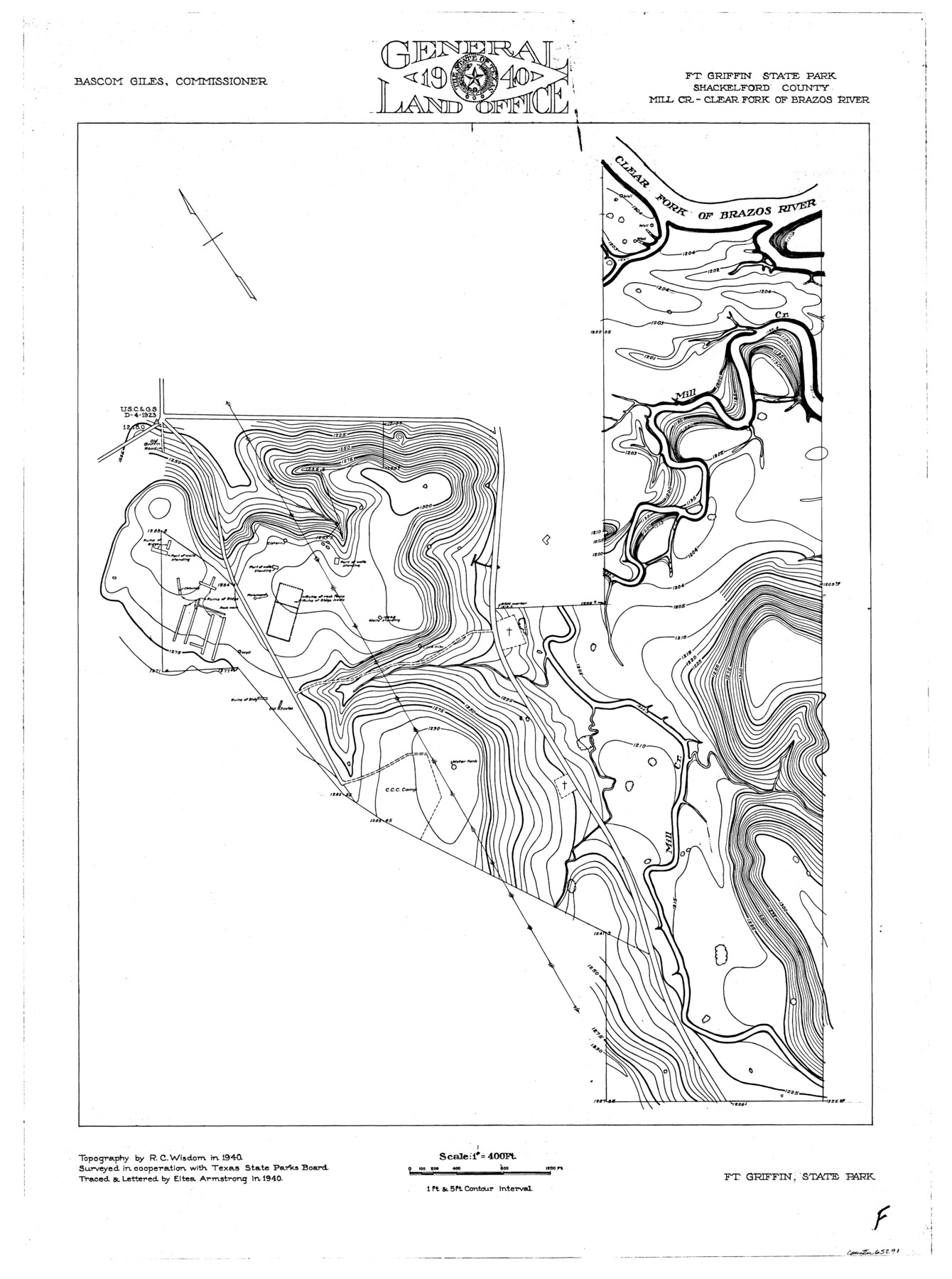
Brazos River, Ft. Griffin State Park/Mill Cr.-Clear Fork of Brazos River
-
Map/Doc
65291
-
Collection
General Map Collection
-
Object Dates
1940 (Creation Date)
-
People and Organizations
Texas General Land Office (Publisher)
Eltea Armstrong (Compiler)
Eltea Armstrong (Draftsman)
Bascom Giles (GLO Commissioner)
R.C. Wisdom (Surveyor/Engineer)
-
Counties
Shackelford
-
Subjects
River Surveys Topographic
-
Height x Width
27.5 x 20.5 inches
69.9 x 52.1 cm
Part of: General Map Collection
Loving County Rolled Sketch 19

Print $20.00
- Digital $50.00
Loving County Rolled Sketch 19
2020
Size 24.4 x 35.3 inches
Map/Doc 96575
El Paso County Working Sketch 23

Print $20.00
- Digital $50.00
El Paso County Working Sketch 23
1961
Size 22.3 x 28.8 inches
Map/Doc 69045
Map of Palo Pinto County

Print $20.00
- Digital $50.00
Map of Palo Pinto County
1898
Size 45.8 x 37.6 inches
Map/Doc 16783
Aransas County Boundary File 4

Print $30.00
- Digital $50.00
Aransas County Boundary File 4
Size 9.2 x 7.8 inches
Map/Doc 49790
Terrell County Working Sketch 10

Print $20.00
- Digital $50.00
Terrell County Working Sketch 10
1924
Size 28.0 x 25.9 inches
Map/Doc 62159
Flight Mission No. CRE-2R, Frame 81, Jackson County

Print $20.00
- Digital $50.00
Flight Mission No. CRE-2R, Frame 81, Jackson County
1956
Size 18.6 x 22.2 inches
Map/Doc 85353
Galveston County Sketch File 58

Print $20.00
- Digital $50.00
Galveston County Sketch File 58
1984
Size 47.1 x 38.3 inches
Map/Doc 10458
Uvalde County Working Sketch 40

Print $20.00
- Digital $50.00
Uvalde County Working Sketch 40
1975
Size 21.2 x 19.6 inches
Map/Doc 72110
Coleman County Sketch File 17

Print $4.00
- Digital $50.00
Coleman County Sketch File 17
Size 12.6 x 7.9 inches
Map/Doc 18685
Wharton County Working Sketch 6

Print $20.00
- Digital $50.00
Wharton County Working Sketch 6
1990
Size 24.7 x 21.1 inches
Map/Doc 72470
Cameron County Rolled Sketch 20E

Print $20.00
- Digital $50.00
Cameron County Rolled Sketch 20E
Size 13.0 x 12.5 inches
Map/Doc 5478
Hardin County Sketch File X

Print $9.00
- Digital $50.00
Hardin County Sketch File X
Size 8.2 x 8.3 inches
Map/Doc 25075
You may also like
Culberson County Sketch File 24

Print $34.00
- Digital $50.00
Culberson County Sketch File 24
1934
Size 11.2 x 9.0 inches
Map/Doc 20242
Cameron County Rolled Sketch 30

Print $20.00
- Digital $50.00
Cameron County Rolled Sketch 30
1930
Size 36.3 x 24.4 inches
Map/Doc 5394
[Capitol Leagues 217-228, 238, and vicinity]
![90672, [Capitol Leagues 217-228, 238, and vicinity], Twichell Survey Records](https://historictexasmaps.com/wmedia_w700/maps/90672-1.tif.jpg)
Print $20.00
- Digital $50.00
[Capitol Leagues 217-228, 238, and vicinity]
Size 23.0 x 9.9 inches
Map/Doc 90672
Val Verde County Rolled Sketch 33

Print $20.00
- Digital $50.00
Val Verde County Rolled Sketch 33
1891
Size 27.8 x 28.2 inches
Map/Doc 8112
Marion County Working Sketch 42

Print $20.00
- Digital $50.00
Marion County Working Sketch 42
2000
Size 29.6 x 41.4 inches
Map/Doc 70818
Harris County Rolled Sketch 41

Print $20.00
- Digital $50.00
Harris County Rolled Sketch 41
1912
Size 21.0 x 34.1 inches
Map/Doc 6099
Stonewall County Sketch File 19

Print $20.00
- Digital $50.00
Stonewall County Sketch File 19
Size 33.2 x 33.6 inches
Map/Doc 10392
[Warren Additions 3 and 4 and vicinity]
![92464, [Warren Additions 3 and 4 and vicinity], Twichell Survey Records](https://historictexasmaps.com/wmedia_w700/maps/92464-1.tif.jpg)
Print $20.00
- Digital $50.00
[Warren Additions 3 and 4 and vicinity]
Size 23.9 x 19.5 inches
Map/Doc 92464
El Paso County Rolled Sketch W

Print $20.00
- Digital $50.00
El Paso County Rolled Sketch W
1916
Size 22.8 x 40.1 inches
Map/Doc 5859
Map of east part of West Bay & SW part of Galveston Bay, Galveston County showing subdivision for mineral development

Print $40.00
- Digital $50.00
Map of east part of West Bay & SW part of Galveston Bay, Galveston County showing subdivision for mineral development
1963
Size 43.0 x 60.8 inches
Map/Doc 2976
El Paso County Working Sketch 58

Print $20.00
- Digital $50.00
El Paso County Working Sketch 58
Size 25.8 x 30.6 inches
Map/Doc 69080
Aransas Pass to Baffin Bay

Print $20.00
- Digital $50.00
Aransas Pass to Baffin Bay
1961
Size 42.1 x 35.4 inches
Map/Doc 73414