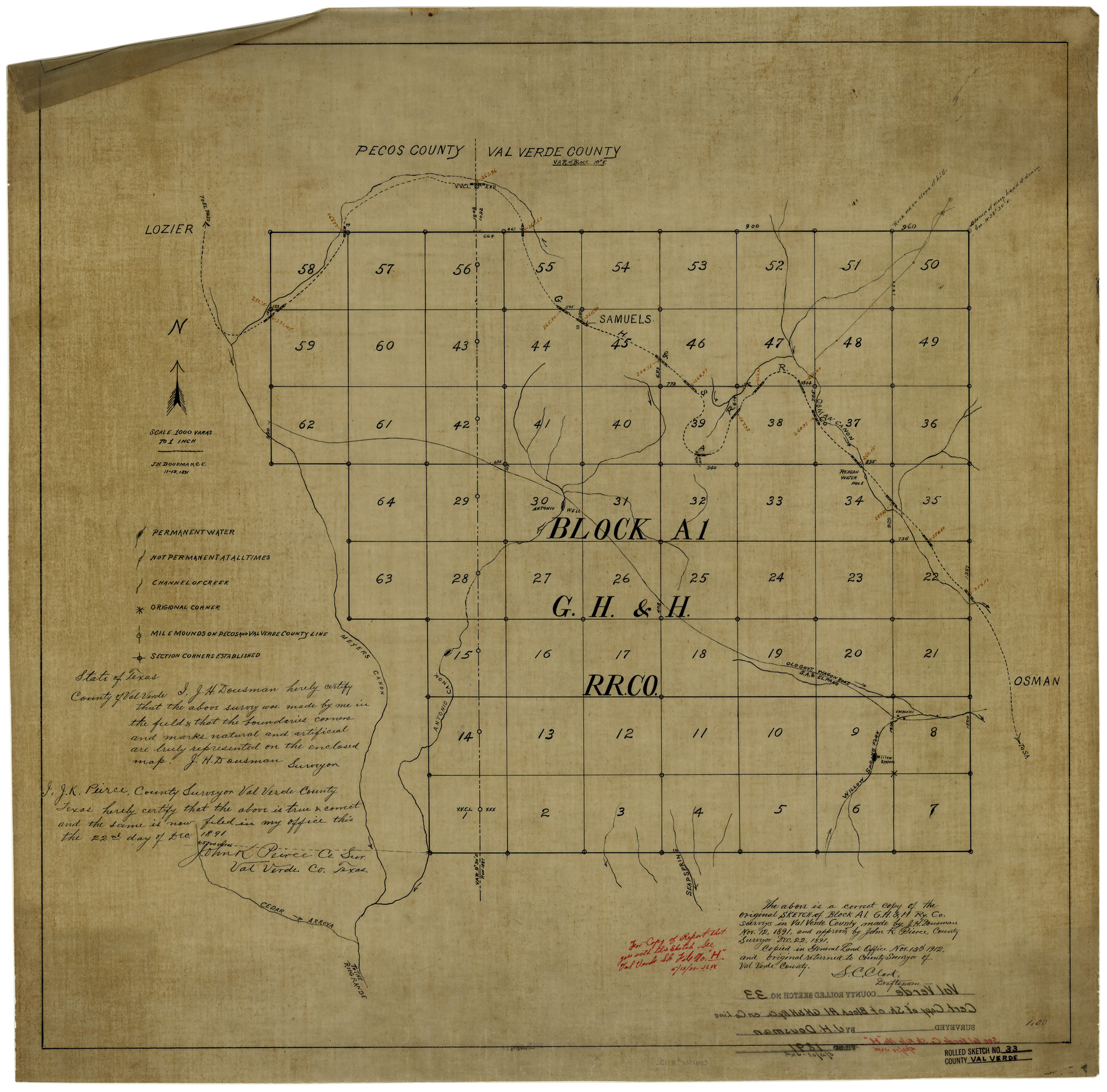
Val Verde County Rolled Sketch 33
[Sketch of Block A-1, G. H. & H. Ry. Co. in Val Verde and Terrell Counties]
-
Map/Doc
8112
-
Collection
General Map Collection
-
Object Dates
11/12/1891 (Creation Date)
11/13/1912 (File Date)
-
People and Organizations
J.H. Dousman (Surveyor/Engineer)
-
Counties
Val Verde Terrell
-
Subjects
Surveying Rolled Sketch
-
Height x Width
27.8 x 28.2 inches
70.6 x 71.6 cm
-
Medium
linen, manuscript
-
Scale
1" = 1000 varas
-
Comments
See Val Verde County Sketch File H (39291) for report.
Related maps
Val Verde County Sketch File H

Print $14.00
- Digital $50.00
Val Verde County Sketch File H
1891
Size 8.9 x 6.9 inches
Map/Doc 39291
Part of: General Map Collection
Controlled Mosaic by Jack Amman Photogrammetric Engineers, Inc - Sheet 11

Print $20.00
- Digital $50.00
Controlled Mosaic by Jack Amman Photogrammetric Engineers, Inc - Sheet 11
1954
Size 20.0 x 24.0 inches
Map/Doc 83455
Hill County Working Sketch 2

Print $20.00
- Digital $50.00
Hill County Working Sketch 2
1947
Size 24.2 x 26.7 inches
Map/Doc 66188
Nacogdoches County Sketch File 13

Print $6.00
- Digital $50.00
Nacogdoches County Sketch File 13
1883
Size 14.2 x 8.7 inches
Map/Doc 32256
Terrell County Rolled Sketch 46

Print $20.00
- Digital $50.00
Terrell County Rolled Sketch 46
1958
Size 16.1 x 14.6 inches
Map/Doc 7948
Flight Mission No. CRC-3R, Frame 102, Chambers County

Print $20.00
- Digital $50.00
Flight Mission No. CRC-3R, Frame 102, Chambers County
1956
Size 18.7 x 22.5 inches
Map/Doc 84840
McCulloch County Sketch File 9

Print $6.00
- Digital $50.00
McCulloch County Sketch File 9
1883
Size 7.3 x 8.7 inches
Map/Doc 31184
Shelby County Rolled Sketch 13

Print $20.00
- Digital $50.00
Shelby County Rolled Sketch 13
1945
Size 24.5 x 27.8 inches
Map/Doc 7781
Wharton County Sketch File A3

Print $26.00
- Digital $50.00
Wharton County Sketch File A3
1899
Size 18.2 x 18.6 inches
Map/Doc 12671
Galveston Harbor, Texas

Print $20.00
- Digital $50.00
Galveston Harbor, Texas
1882
Size 15.0 x 19.5 inches
Map/Doc 97281

Flight Mission No. DIX-6P, Frame 195, Aransas County

Print $20.00
- Digital $50.00
Flight Mission No. DIX-6P, Frame 195, Aransas County
1956
Size 19.0 x 22.7 inches
Map/Doc 83857
Irion County Rolled Sketch 2

Print $20.00
- Digital $50.00
Irion County Rolled Sketch 2
Size 27.8 x 39.7 inches
Map/Doc 6317
You may also like
Gillespie County Working Sketch Graphic Index

Print $20.00
- Digital $50.00
Gillespie County Working Sketch Graphic Index
1945
Size 38.0 x 47.4 inches
Map/Doc 76553
Bastrop County Sketch File 13

Print $6.00
- Digital $50.00
Bastrop County Sketch File 13
1845
Size 10.1 x 15.8 inches
Map/Doc 14070
Chambers County Sketch File 25

Print $8.00
- Digital $50.00
Chambers County Sketch File 25
Size 14.1 x 8.7 inches
Map/Doc 17602
Catalogue of the Spanish Collection of the Texas General Land Office

Digital $15.00
Catalogue of the Spanish Collection of the Texas General Land Office
2003
Size 10.8 x 8.5 inches
Map/Doc 83387
J. F. Kelley Farm

Print $20.00
- Digital $50.00
J. F. Kelley Farm
Size 16.3 x 19.5 inches
Map/Doc 92408
Flight Mission No. DQN-2K, Frame 24, Calhoun County

Print $20.00
- Digital $50.00
Flight Mission No. DQN-2K, Frame 24, Calhoun County
1953
Size 18.6 x 22.2 inches
Map/Doc 84231
General Highway Map, Upshur County, Gregg County, Texas

Print $20.00
General Highway Map, Upshur County, Gregg County, Texas
1939
Size 24.9 x 18.6 inches
Map/Doc 79105
Hispania Nova

Print $20.00
- Digital $50.00
Hispania Nova
1597
Size 12.0 x 14.9 inches
Map/Doc 94120
Laredo Route. Mexican National Railroad - the Shortest Line to Mexico

Print $20.00
- Digital $50.00
Laredo Route. Mexican National Railroad - the Shortest Line to Mexico
1905
Size 11.0 x 8.5 inches
Map/Doc 96589
Brooks County Working Sketch 15

Print $20.00
- Digital $50.00
Brooks County Working Sketch 15
1944
Size 30.5 x 20.5 inches
Map/Doc 67799
Townships 14 and 15 South Range 16 West of the Louisiana Meridian, Louisiana

Print $20.00
- Digital $50.00
Townships 14 and 15 South Range 16 West of the Louisiana Meridian, Louisiana
1875
Size 19.7 x 24.8 inches
Map/Doc 65860
Gregg County Boundary File 2

Print $8.00
- Digital $50.00
Gregg County Boundary File 2
Size 8.8 x 3.7 inches
Map/Doc 53984