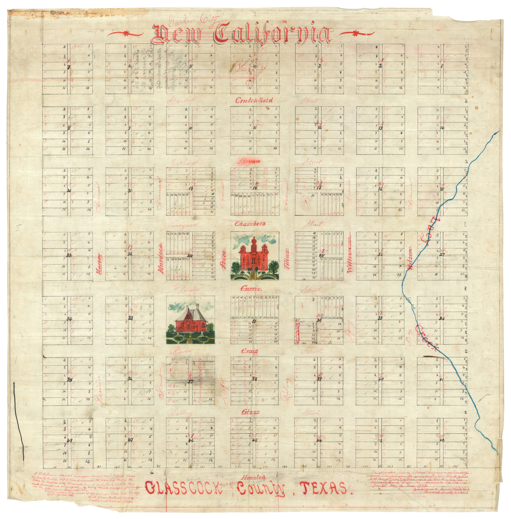
Garden City
New California
-
Map/Doc
97252
-
Collection
General Map Collection
-
Object Dates
5/20/1892 (Creation Date)
-
People and Organizations
J.L. Chambers (Surveyor/Engineer)
-
Counties
Glasscock
-
Subjects
City
-
Height x Width
32.2 x 31.7 inches
81.8 x 80.5 cm
-
Comments
Originally housed in School File 25672.
Part of: General Map Collection
Southern Pacific Lines in Texas and Louisiana (G. H. & S. A. Ry.) Circuit Plan of Automatic Block Signals, Automatic Train Control and Flatonia Interlocking Plant No. 3

Print $40.00
- Digital $50.00
Southern Pacific Lines in Texas and Louisiana (G. H. & S. A. Ry.) Circuit Plan of Automatic Block Signals, Automatic Train Control and Flatonia Interlocking Plant No. 3
1927
Size 43.5 x 215.5 inches
Map/Doc 90044
Rusk County Sketch File 41

Print $20.00
Rusk County Sketch File 41
1951
Size 23.1 x 26.2 inches
Map/Doc 12277
[Maps of surveys in Reeves & Culberson Cos]
![61145, [Maps of surveys in Reeves & Culberson Cos], General Map Collection](https://historictexasmaps.com/wmedia_w700/maps/61145.tif.jpg)
Print $20.00
- Digital $50.00
[Maps of surveys in Reeves & Culberson Cos]
1937
Size 30.8 x 25.0 inches
Map/Doc 61145
Phelps & Ensign's Travellers' Guide, and Map of the United States containing the roads, distances, steam boat and canal routes & c.

Print $20.00
- Digital $50.00
Phelps & Ensign's Travellers' Guide, and Map of the United States containing the roads, distances, steam boat and canal routes & c.
1841
Size 28.8 x 33.9 inches
Map/Doc 96875
Lynn County Sketch File 18

Print $4.00
- Digital $50.00
Lynn County Sketch File 18
1940
Size 11.2 x 8.8 inches
Map/Doc 30514
Flight Mission No. CRK-5P, Frame 127, Refugio County

Print $20.00
- Digital $50.00
Flight Mission No. CRK-5P, Frame 127, Refugio County
1956
Size 18.4 x 22.3 inches
Map/Doc 86930
Crockett County Sketch File 35c

Print $8.00
- Digital $50.00
Crockett County Sketch File 35c
Size 14.3 x 8.8 inches
Map/Doc 19746
Map of the Western Branch of Houston & Tex. Central R.R. for the Distance from Brenham to Austin

Print $40.00
- Digital $50.00
Map of the Western Branch of Houston & Tex. Central R.R. for the Distance from Brenham to Austin
1872
Size 32.6 x 97.3 inches
Map/Doc 64578
Hall County Sketch File 6

Print $20.00
- Digital $50.00
Hall County Sketch File 6
1885
Size 28.2 x 37.9 inches
Map/Doc 10473
Matagorda County NRC Article 33.136 Sketch 6

Print $42.00
- Digital $50.00
Matagorda County NRC Article 33.136 Sketch 6
2010
Size 22.0 x 34.0 inches
Map/Doc 94646
Current Miscellaneous File 70

Print $10.00
- Digital $50.00
Current Miscellaneous File 70
Size 14.2 x 8.9 inches
Map/Doc 74150
Presidio County Working Sketch 72

Print $20.00
- Digital $50.00
Presidio County Working Sketch 72
1962
Size 22.1 x 21.1 inches
Map/Doc 71749
You may also like
Eastland County Working Sketch 54

Print $20.00
- Digital $50.00
Eastland County Working Sketch 54
1984
Size 19.6 x 18.0 inches
Map/Doc 68835
Burnet County Sketch File 17

Print $6.00
- Digital $50.00
Burnet County Sketch File 17
Size 12.4 x 10.1 inches
Map/Doc 16706
Flight Mission No. DIX-5P, Frame 145, Aransas County

Print $20.00
- Digital $50.00
Flight Mission No. DIX-5P, Frame 145, Aransas County
1956
Size 17.8 x 18.1 inches
Map/Doc 83806

Lee County Working Sketch 18

Print $20.00
- Digital $50.00
Lee County Working Sketch 18
1989
Size 18.3 x 17.2 inches
Map/Doc 70397
Starr County Rolled Sketch 42

Print $20.00
- Digital $50.00
Starr County Rolled Sketch 42
1972
Size 26.0 x 18.4 inches
Map/Doc 7835
Wilbarger County Boundary File 1

Print $52.00
- Digital $50.00
Wilbarger County Boundary File 1
Size 8.9 x 5.6 inches
Map/Doc 59916
Kimble County Sketch File 13

Print $24.00
- Digital $50.00
Kimble County Sketch File 13
1885
Size 14.1 x 8.6 inches
Map/Doc 28937
Reeves County Rolled Sketch 25

Print $20.00
- Digital $50.00
Reeves County Rolled Sketch 25
1982
Size 22.3 x 20.6 inches
Map/Doc 7494
Jasper County Working Sketch 2

Print $20.00
- Digital $50.00
Jasper County Working Sketch 2
Size 18.6 x 22.5 inches
Map/Doc 66464
Big Lake Oil Field

Print $20.00
- Digital $50.00
Big Lake Oil Field
1924
Size 27.3 x 19.1 inches
Map/Doc 2420
Brewster County Sketch File N-3d

Print $13.00
- Digital $50.00
Brewster County Sketch File N-3d
1889
Size 14.2 x 8.7 inches
Map/Doc 15596