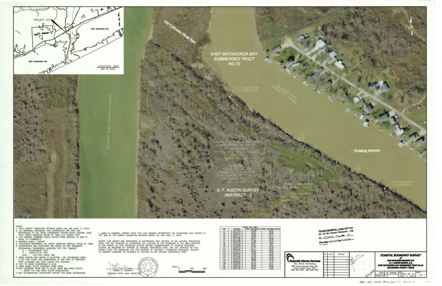
Matagorda County NRC Article 33.136 Sketch 6
Coastal Boundary Survey at the proposed Bragg's Cut S.F. Austin survey, A-2, East Matagorda Bay submerged tract No. 10
-
Map/Doc
94646
-
Collection
General Map Collection
-
Object Dates
2010/8/23 (Creation Date)
2018/6/20 (File Date)
-
People and Organizations
James M. Naismith (Surveyor/Engineer)
-
Counties
Matagorda
-
Subjects
Surveying CBS
-
Height x Width
22.0 x 34.0 inches
55.9 x 86.4 cm
-
Medium
multi-page, multi-format
-
Comments
Project: Bragg's Cut - Matagorda County Project No.: SL20100061 (GLO)
Part of: General Map Collection
Brazoria County Sketch File 45

Print $20.00
- Digital $50.00
Brazoria County Sketch File 45
1980
Size 32.0 x 43.1 inches
Map/Doc 10326

Brewster County Rolled Sketch 114

Print $20.00
- Digital $50.00
Brewster County Rolled Sketch 114
1964
Size 12.1 x 18.3 inches
Map/Doc 5285
Flight Mission No. BRA-7M, Frame 83, Jefferson County

Print $20.00
- Digital $50.00
Flight Mission No. BRA-7M, Frame 83, Jefferson County
1953
Size 16.1 x 16.1 inches
Map/Doc 85505
Jefferson County Working Sketch 26

Print $20.00
- Digital $50.00
Jefferson County Working Sketch 26
1977
Size 39.9 x 36.8 inches
Map/Doc 66569
Wood County Boundary File 5

Print $20.00
- Digital $50.00
Wood County Boundary File 5
Size 10.8 x 8.1 inches
Map/Doc 60170
Floyd County Sketch File 18

Print $32.00
- Digital $50.00
Floyd County Sketch File 18
1913
Size 13.4 x 9.0 inches
Map/Doc 22753
Live Oak County Sketch File 32

Print $6.00
- Digital $50.00
Live Oak County Sketch File 32
1951
Size 11.1 x 8.6 inches
Map/Doc 30330

Map of Denton County

Print $20.00
- Digital $50.00
Map of Denton County
1897
Size 45.0 x 41.2 inches
Map/Doc 66802
Harris County Rolled Sketch 31

Print $40.00
- Digital $50.00
Harris County Rolled Sketch 31
1893
Size 63.5 x 40.0 inches
Map/Doc 9111
Upshur County Working Sketch 14

Print $20.00
- Digital $50.00
Upshur County Working Sketch 14
1993
Size 23.1 x 37.1 inches
Map/Doc 69571
You may also like
Bandera County Working Sketch 25

Print $20.00
- Digital $50.00
Bandera County Working Sketch 25
1950
Size 30.4 x 38.5 inches
Map/Doc 67621
Dickens County Boundary File 1

Print $6.00
- Digital $50.00
Dickens County Boundary File 1
Size 8.8 x 3.7 inches
Map/Doc 52530
University Land Field Notes for Blocks 34 through 37 in Terrell County

University Land Field Notes for Blocks 34 through 37 in Terrell County
Map/Doc 81720
Flight Mission No. BRA-16M, Frame 54, Jefferson County

Print $20.00
- Digital $50.00
Flight Mission No. BRA-16M, Frame 54, Jefferson County
1953
Size 18.5 x 22.5 inches
Map/Doc 85671
Morris County Rolled Sketch 2A

Print $20.00
- Digital $50.00
Morris County Rolled Sketch 2A
Size 22.6 x 17.7 inches
Map/Doc 10285
Leon County Working Sketch 26

Print $20.00
- Digital $50.00
Leon County Working Sketch 26
1969
Size 43.1 x 46.9 inches
Map/Doc 70425
Jones County Working Sketch 5

Print $20.00
- Digital $50.00
Jones County Working Sketch 5
1950
Size 35.5 x 29.3 inches
Map/Doc 66643
Descripçion de las Yndias del Norte

Print $20.00
- Digital $50.00
Descripçion de las Yndias del Norte
1601
Size 11.4 x 13.9 inches
Map/Doc 94850
Cooke County Working Sketch 23

Print $20.00
- Digital $50.00
Cooke County Working Sketch 23
1969
Size 32.1 x 33.4 inches
Map/Doc 68260
Val Verde County Sketch File Z6

Print $20.00
- Digital $50.00
Val Verde County Sketch File Z6
Size 29.3 x 26.2 inches
Map/Doc 10425
Johnson's Texas

Print $20.00
- Digital $50.00
Johnson's Texas
1866
Size 18.4 x 27.2 inches
Map/Doc 89279
Red River County Working Sketch 29

Print $20.00
- Digital $50.00
Red River County Working Sketch 29
1961
Size 29.5 x 33.3 inches
Map/Doc 72012