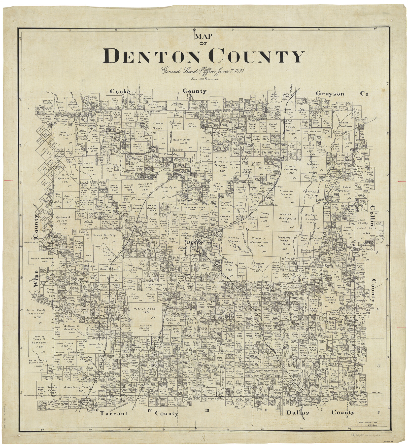
Map of Denton County
-
Map/Doc
66802
-
Collection
General Map Collection
-
Object Dates
6/7/1897 (Creation Date)
-
People and Organizations
Texas General Land Office (Publisher)
-
Counties
Denton
-
Subjects
County
-
Height x Width
45.0 x 41.2 inches
114.3 x 104.7 cm
-
Comments
Traced in September 1932 by W. B. Smith.
Part of: General Map Collection
King County Working Sketch 1

Print $20.00
- Digital $50.00
King County Working Sketch 1
1913
Size 18.2 x 23.8 inches
Map/Doc 70165
![94197, New Mexico [Verso], General Map Collection](https://historictexasmaps.com/wmedia_w700/maps/94197.tif.jpg)
Fayette County Rolled Sketch K

Print $20.00
- Digital $50.00
Fayette County Rolled Sketch K
1936
Size 41.2 x 40.0 inches
Map/Doc 8886
Deaf Smith County

Print $40.00
- Digital $50.00
Deaf Smith County
1926
Size 41.4 x 54.3 inches
Map/Doc 1816
Medina County Working Sketch 21

Print $20.00
- Digital $50.00
Medina County Working Sketch 21
1982
Size 18.1 x 23.3 inches
Map/Doc 70936
Real County Working Sketch 66

Print $20.00
- Digital $50.00
Real County Working Sketch 66
1970
Size 35.5 x 29.4 inches
Map/Doc 71958
Kerr County Boundary File 2

Print $46.00
- Digital $50.00
Kerr County Boundary File 2
Size 15.6 x 26.5 inches
Map/Doc 55984
[Gulf, Colorado & Santa Fe]
![64576, [Gulf, Colorado & Santa Fe], General Map Collection](https://historictexasmaps.com/wmedia_w700/maps/64576.tif.jpg)
Print $40.00
- Digital $50.00
[Gulf, Colorado & Santa Fe]
Size 32.4 x 84.9 inches
Map/Doc 64576
Hartley County Sketch File 12

Print $20.00
- Digital $50.00
Hartley County Sketch File 12
1906
Size 16.3 x 12.4 inches
Map/Doc 11736
Galveston County Working Sketch 13

Print $20.00
- Digital $50.00
Galveston County Working Sketch 13
1975
Size 23.1 x 16.7 inches
Map/Doc 69350
Hudspeth County Working Sketch 33

Print $20.00
- Digital $50.00
Hudspeth County Working Sketch 33
1977
Size 26.8 x 21.4 inches
Map/Doc 66318
Pecos County Rolled Sketch 172

Print $453.00
- Digital $50.00
Pecos County Rolled Sketch 172
Size 10.4 x 15.0 inches
Map/Doc 48632
You may also like
Andrews County Rolled Sketch 26

Print $40.00
- Digital $50.00
Andrews County Rolled Sketch 26
1948
Size 78.3 x 13.2 inches
Map/Doc 8398
Matagorda County Sketch File 13

Print $20.00
- Digital $50.00
Matagorda County Sketch File 13
1902
Size 21.5 x 19.0 inches
Map/Doc 12039
Right of Way and Track Map Texas & New Orleans R.R. Co. operated by the T. & N. O. R.R. Co. Dallas-Sabine Branch

Print $40.00
- Digital $50.00
Right of Way and Track Map Texas & New Orleans R.R. Co. operated by the T. & N. O. R.R. Co. Dallas-Sabine Branch
1918
Size 26.1 x 56.7 inches
Map/Doc 64150
Flight Mission No. CGI-3N, Frame 94, Cameron County

Print $20.00
- Digital $50.00
Flight Mission No. CGI-3N, Frame 94, Cameron County
1954
Size 18.6 x 22.1 inches
Map/Doc 84574

Clay County Sketch File 34

Print $4.00
- Digital $50.00
Clay County Sketch File 34
Size 9.6 x 7.4 inches
Map/Doc 18461
Borden County Sketch File 4

Print $24.00
- Digital $50.00
Borden County Sketch File 4
1903
Size 8.8 x 7.8 inches
Map/Doc 14707
Map of Bowie County

Print $20.00
- Digital $50.00
Map of Bowie County
1884
Size 19.4 x 23.7 inches
Map/Doc 3319
[Map of Nueces Bay Showing Old Leases]
![2924, [Map of Nueces Bay Showing Old Leases], General Map Collection](https://historictexasmaps.com/wmedia_w700/maps/2924-1.tif.jpg)
Print $20.00
- Digital $50.00
[Map of Nueces Bay Showing Old Leases]
1936
Size 18.0 x 22.9 inches
Map/Doc 2924
Travis County Working Sketch 13

Print $20.00
- Digital $50.00
Travis County Working Sketch 13
1930
Size 20.5 x 27.3 inches
Map/Doc 69397
Brazoria County Rolled Sketch 19

Print $20.00
- Digital $50.00
Brazoria County Rolled Sketch 19
Size 16.9 x 19.0 inches
Map/Doc 5166
Gregg County Working Sketch 15

Print $20.00
- Digital $50.00
Gregg County Working Sketch 15
1941
Size 24.8 x 29.5 inches
Map/Doc 63282