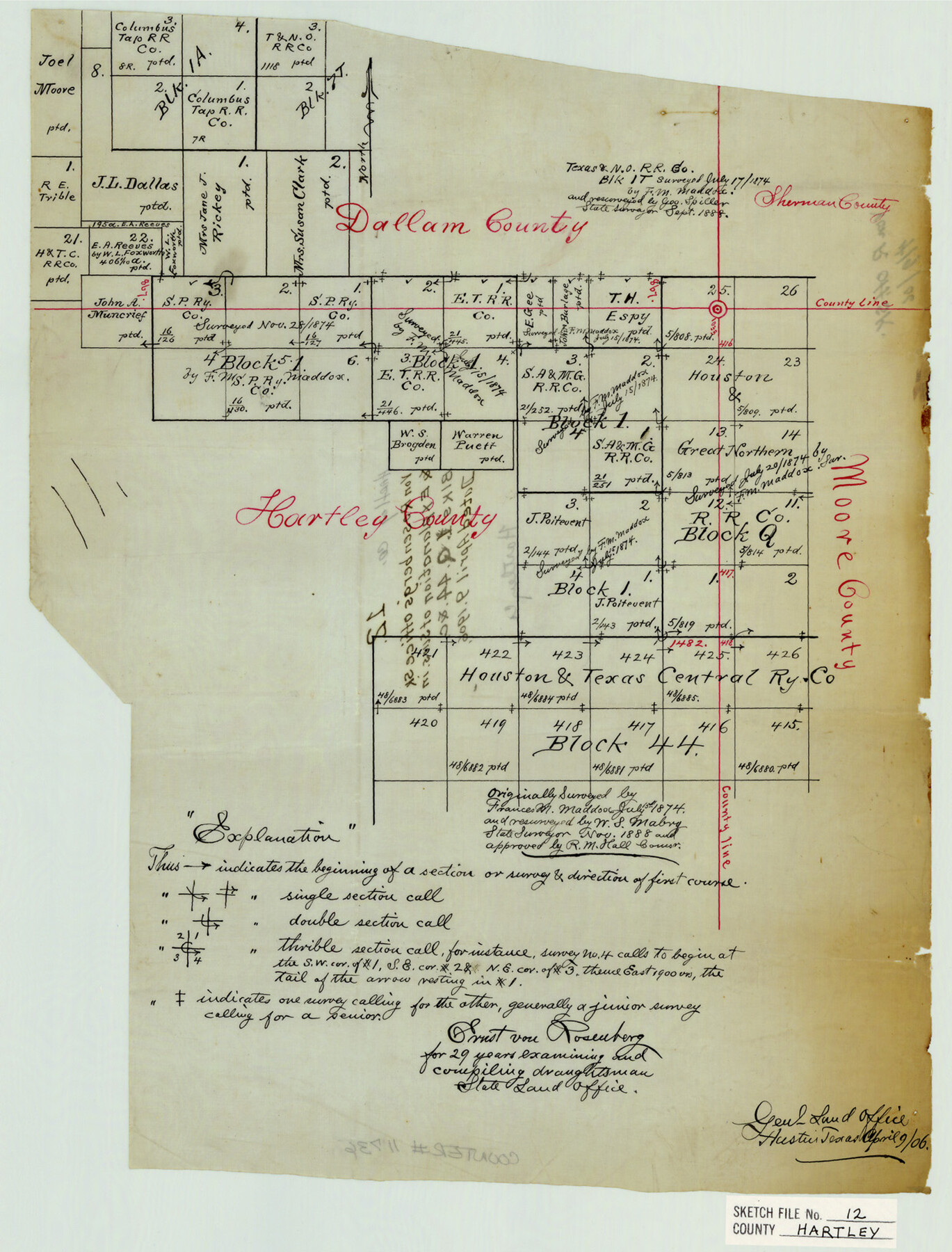
Hartley County Sketch File 12
von Rosenberg's office sk. & explanation of surs. in Blks. 1, Q, 44 & C
-
Map/Doc
11736
-
Collection
General Map Collection
-
Object Dates
1906/4/9 (Creation Date)
1888 (Survey Date)
1874 (Survey Date)
-
People and Organizations
Ernst Von Rosenberg (Draftsman)
Frances M. Maddox (Surveyor/Engineer)
W.S. Mabry (Surveyor/Engineer)
-
Counties
Hartley Dallam Sherman Moore
-
Subjects
Surveying Sketch File
-
Height x Width
16.3 x 12.4 inches
41.4 x 31.5 cm
-
Medium
paper, manuscript
Part of: General Map Collection
[Surveys in the Milam District on Bosque River and Spring Creek]
![3170, [Surveys in the Milam District on Bosque River and Spring Creek], General Map Collection](https://historictexasmaps.com/wmedia_w700/maps/3170.tif.jpg)
Print $20.00
- Digital $50.00
[Surveys in the Milam District on Bosque River and Spring Creek]
1846
Size 13.3 x 14.7 inches
Map/Doc 3170
Fractional Township No. 7 South Range No 3 West of the Indian Meridian, Indian Territory

Print $20.00
- Digital $50.00
Fractional Township No. 7 South Range No 3 West of the Indian Meridian, Indian Territory
1898
Size 19.2 x 24.5 inches
Map/Doc 75193
Collin County Boundary File 18 and 18a

Print $8.00
- Digital $50.00
Collin County Boundary File 18 and 18a
Size 7.8 x 4.0 inches
Map/Doc 51717
Reagan County Sketch File 4

Print $20.00
- Digital $50.00
Reagan County Sketch File 4
Size 20.8 x 29.8 inches
Map/Doc 12214
Galveston County Rolled Sketch 23

Print $24.00
- Digital $50.00
Galveston County Rolled Sketch 23
1955
Size 10.0 x 15.2 inches
Map/Doc 45081
Hamilton County Sketch File 8

Print $4.00
- Digital $50.00
Hamilton County Sketch File 8
1860
Size 12.2 x 8.0 inches
Map/Doc 24914
Travis County

Print $40.00
- Digital $50.00
Travis County
1880
Size 59.0 x 70.2 inches
Map/Doc 16902
Map of Liberty County

Print $40.00
- Digital $50.00
Map of Liberty County
1903
Size 54.9 x 53.6 inches
Map/Doc 16878
Flight Mission No. CGI-3N, Frame 175, Cameron County

Print $20.00
- Digital $50.00
Flight Mission No. CGI-3N, Frame 175, Cameron County
1954
Size 18.6 x 22.3 inches
Map/Doc 84639
Map of Starr County

Print $20.00
- Digital $50.00
Map of Starr County
1880
Size 46.8 x 27.0 inches
Map/Doc 4044
Ochiltree County Working Sketch Graphic Index

Print $20.00
- Digital $50.00
Ochiltree County Working Sketch Graphic Index
1958
Size 41.5 x 32.8 inches
Map/Doc 76656
Flight Mission No. DQN-2K, Frame 195, Calhoun County

Print $20.00
- Digital $50.00
Flight Mission No. DQN-2K, Frame 195, Calhoun County
1953
Size 18.6 x 22.2 inches
Map/Doc 84333
You may also like
Falls County Sketch File 33

Print $4.00
- Digital $50.00
Falls County Sketch File 33
1873
Size 10.3 x 8.3 inches
Map/Doc 22441
McMullen County Working Sketch 51

Print $20.00
- Digital $50.00
McMullen County Working Sketch 51
1983
Size 18.3 x 17.4 inches
Map/Doc 70752
Outer Continental Shelf Leasing Maps (Texas Offshore Operations)

Print $20.00
- Digital $50.00
Outer Continental Shelf Leasing Maps (Texas Offshore Operations)
Size 23.4 x 13.0 inches
Map/Doc 75854
Walker County Working Sketch 11

Print $20.00
- Digital $50.00
Walker County Working Sketch 11
1935
Size 28.2 x 38.8 inches
Map/Doc 72291
Chambers County Sketch File 52

Print $8.00
- Digital $50.00
Chambers County Sketch File 52
1839
Size 13.0 x 8.3 inches
Map/Doc 18083
Dimmit County Working Sketch 3

Print $20.00
- Digital $50.00
Dimmit County Working Sketch 3
1911
Size 16.5 x 22.5 inches
Map/Doc 68664
Flight Mission No. BQY-15M, Frame 13, Harris County

Print $20.00
- Digital $50.00
Flight Mission No. BQY-15M, Frame 13, Harris County
1953
Size 18.8 x 22.5 inches
Map/Doc 85311
Denton County

Print $20.00
- Digital $50.00
Denton County
1947
Size 43.4 x 39.9 inches
Map/Doc 95480

Limestone County Working Sketch 26

Print $20.00
- Digital $50.00
Limestone County Working Sketch 26
1982
Size 39.6 x 44.1 inches
Map/Doc 70576
Irion County Sketch File 9

Print $14.00
- Digital $50.00
Irion County Sketch File 9
1927
Size 11.0 x 8.5 inches
Map/Doc 27475
Red River County Sketch File 12

Print $40.00
- Digital $50.00
Red River County Sketch File 12
Size 12.5 x 21.5 inches
Map/Doc 35129