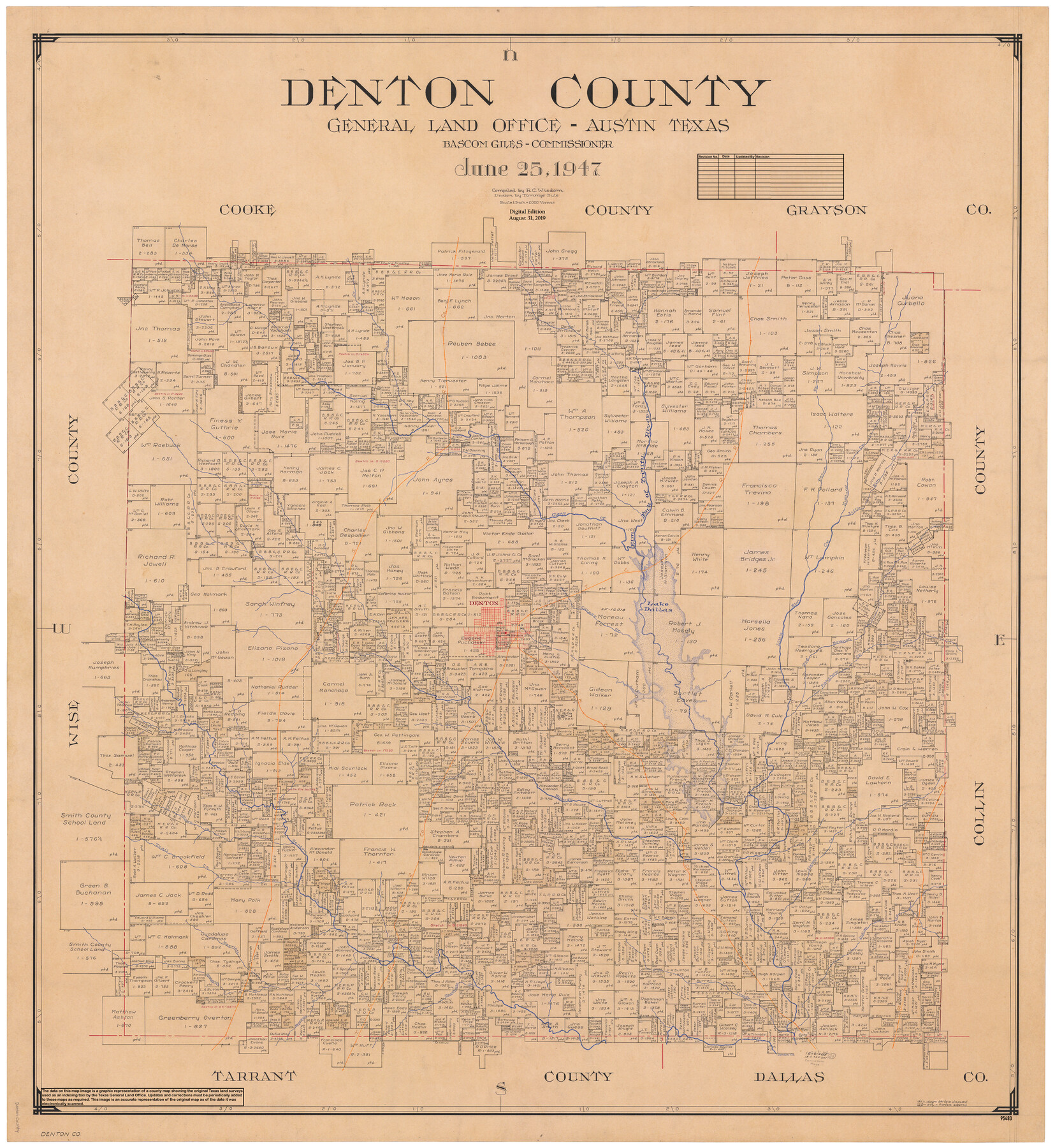
Denton County
General Land Office Official County Map
-
Map/Doc
95480
-
Collection
General Map Collection
-
Object Dates
2019/8/31 (Revision Date)
1947/6/25 (Creation Date)
-
People and Organizations
Cheyenne Betancourt (Draftsman)
Tommye Buie (Draftsman)
R.C. Wisdom (Compiler)
Bascom Giles (GLO Commissioner)
-
Counties
Denton
-
Subjects
County OCM
-
Height x Width
43.4 x 39.9 inches
110.2 x 101.3 cm
-
Medium
digital image
-
Scale
1" = 2000 varas
Part of: General Map Collection
Travis County Sketch File 34

Print $26.00
- Digital $50.00
Travis County Sketch File 34
1888
Size 26.8 x 27.9 inches
Map/Doc 12461
Chambers County Rolled Sketch 25

Print $20.00
- Digital $50.00
Chambers County Rolled Sketch 25
1944
Size 33.9 x 31.5 inches
Map/Doc 8618
Zavala County Sketch File 7

Print $6.00
- Digital $50.00
Zavala County Sketch File 7
Size 9.4 x 16.3 inches
Map/Doc 41265
Cochran County Boundary File 7

Print $6.00
- Digital $50.00
Cochran County Boundary File 7
Size 14.0 x 9.1 inches
Map/Doc 51567
Roberts County Sketch File 5

Print $4.00
- Digital $50.00
Roberts County Sketch File 5
Size 8.0 x 9.8 inches
Map/Doc 35312
Medina County Working Sketch 16

Print $20.00
- Digital $50.00
Medina County Working Sketch 16
1979
Size 27.1 x 28.2 inches
Map/Doc 70931
Montgomery County Rolled Sketch 42

Print $20.00
- Digital $50.00
Montgomery County Rolled Sketch 42
1939
Size 14.1 x 20.1 inches
Map/Doc 6818
Bowie County Sketch File 6d

Print $4.00
- Digital $50.00
Bowie County Sketch File 6d
1927
Size 11.4 x 9.0 inches
Map/Doc 14850
Uvalde County Working Sketch 12

Print $20.00
- Digital $50.00
Uvalde County Working Sketch 12
1943
Size 28.5 x 27.4 inches
Map/Doc 72082
Newton County Sketch File 46

Print $18.00
- Digital $50.00
Newton County Sketch File 46
1962
Size 11.2 x 8.6 inches
Map/Doc 32451
Freestone County Sketch File 23

Print $6.00
- Digital $50.00
Freestone County Sketch File 23
1918
Size 11.4 x 8.9 inches
Map/Doc 23084
Brazoria County Working Sketch 33

Print $20.00
- Digital $50.00
Brazoria County Working Sketch 33
1980
Size 29.6 x 35.6 inches
Map/Doc 67518
You may also like
[Galveston, Harrisburg & San Antonio through El Paso County]
![64010, [Galveston, Harrisburg & San Antonio through El Paso County], General Map Collection](https://historictexasmaps.com/wmedia_w700/maps/64010.tif.jpg)
Print $20.00
- Digital $50.00
[Galveston, Harrisburg & San Antonio through El Paso County]
1906
Size 13.4 x 33.9 inches
Map/Doc 64010
Sterling County Sketch File 6

Print $12.00
- Digital $50.00
Sterling County Sketch File 6
1912
Size 5.7 x 8.8 inches
Map/Doc 37115
Leon County Working Sketch 30

Print $20.00
- Digital $50.00
Leon County Working Sketch 30
1972
Size 33.1 x 45.1 inches
Map/Doc 70429
Johnson County Rolled Sketch 1

Print $20.00
- Digital $50.00
Johnson County Rolled Sketch 1
1941
Size 19.4 x 33.4 inches
Map/Doc 6446
Yoakum County Sketch File 12

Print $22.00
- Digital $50.00
Yoakum County Sketch File 12
1933
Size 13.8 x 17.8 inches
Map/Doc 40765
Anderson County Boundary File 1

Print $10.00
- Digital $50.00
Anderson County Boundary File 1
Size 14.2 x 8.6 inches
Map/Doc 49726
Comanche County Working Sketch 23

Print $20.00
- Digital $50.00
Comanche County Working Sketch 23
1974
Size 15.7 x 24.7 inches
Map/Doc 68157
[North part of PSL Block A-19 and adjoining School Land Leagues]
![93024, [North part of PSL Block A-19 and adjoining School Land Leagues], Twichell Survey Records](https://historictexasmaps.com/wmedia_w700/maps/93024-1.tif.jpg)
Print $20.00
- Digital $50.00
[North part of PSL Block A-19 and adjoining School Land Leagues]
Size 23.5 x 19.1 inches
Map/Doc 93024
Jeff Davis County Sketch File 13

Print $14.00
- Digital $50.00
Jeff Davis County Sketch File 13
1889
Size 13.9 x 8.5 inches
Map/Doc 27941
Map showing the fortification at Point Isabel

Print $20.00
- Digital $50.00
Map showing the fortification at Point Isabel
1864
Size 18.3 x 27.9 inches
Map/Doc 72921
Carta Eclesiastica

Print $20.00
- Digital $50.00
Carta Eclesiastica
1897
Size 26.1 x 34.1 inches
Map/Doc 96799
McMullen County Sketch File 25

Print $6.00
- Digital $50.00
McMullen County Sketch File 25
1877
Size 8.5 x 14.2 inches
Map/Doc 31383