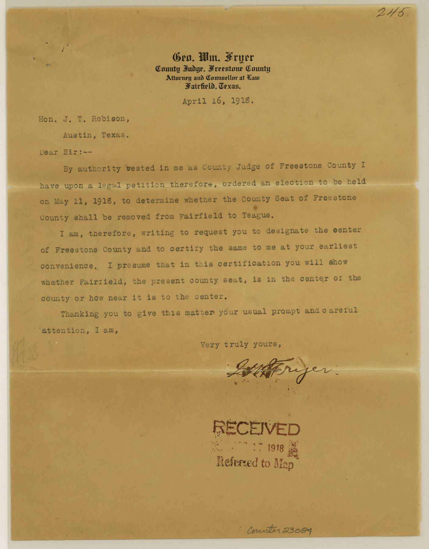
Freestone County Sketch File 23
[Certificate designating the geographic center of Freestone County]
-
Map/Doc
23084
-
Collection
General Map Collection
-
Object Dates
1918/4/19 (Creation Date)
1918/4/19 (File Date)
-
People and Organizations
Clark (Surveyor/Engineer)
J.T. Robison (GLO Commissioner)
-
Counties
Freestone
-
Subjects
Surveying Sketch File
-
Height x Width
11.4 x 8.9 inches
29.0 x 22.6 cm
-
Medium
paper, print
-
Features
Fairfield
Teague
Part of: General Map Collection
Nueces County Sketch File 7

Print $7.00
- Digital $50.00
Nueces County Sketch File 7
1849
Size 11.3 x 9.3 inches
Map/Doc 32509
La Salle County Sketch File 14

Print $4.00
- Digital $50.00
La Salle County Sketch File 14
Size 6.4 x 6.7 inches
Map/Doc 29483
Flight Mission No. CGI-3N, Frame 158, Cameron County

Print $20.00
- Digital $50.00
Flight Mission No. CGI-3N, Frame 158, Cameron County
1954
Size 18.5 x 22.4 inches
Map/Doc 84622
Brewster County Sketch File N-19

Print $40.00
- Digital $50.00
Brewster County Sketch File N-19
1946
Size 18.7 x 26.2 inches
Map/Doc 10966
El Paso County Rolled Sketch 52

Print $20.00
- Digital $50.00
El Paso County Rolled Sketch 52
1932
Size 18.3 x 24.3 inches
Map/Doc 5843
Baylor County Aerial Photograph Index Sheet 2

Print $20.00
- Digital $50.00
Baylor County Aerial Photograph Index Sheet 2
1950
Size 22.2 x 15.4 inches
Map/Doc 83664
Kendall County Working Sketch 7

Print $20.00
- Digital $50.00
Kendall County Working Sketch 7
1950
Size 30.8 x 32.4 inches
Map/Doc 66679
Lamb County Working Sketch 3

Print $20.00
- Digital $50.00
Lamb County Working Sketch 3
1962
Size 32.1 x 37.7 inches
Map/Doc 70276
Val Verde County Working Sketch 80

Print $20.00
- Digital $50.00
Val Verde County Working Sketch 80
1973
Size 29.1 x 46.1 inches
Map/Doc 72215
Terrell County Working Sketch 15

Print $20.00
- Digital $50.00
Terrell County Working Sketch 15
1927
Size 18.7 x 19.8 inches
Map/Doc 62164
Flight Mission No. CGI-3N, Frame 179, Cameron County

Print $20.00
- Digital $50.00
Flight Mission No. CGI-3N, Frame 179, Cameron County
1954
Size 18.6 x 22.2 inches
Map/Doc 84643
Edwards County Rolled Sketch 33

Print $20.00
- Digital $50.00
Edwards County Rolled Sketch 33
1890
Size 25.0 x 25.8 inches
Map/Doc 5815
You may also like
Liberty County Boundary File 1

Print $8.00
- Digital $50.00
Liberty County Boundary File 1
Size 14.2 x 8.9 inches
Map/Doc 56289
Flight Mission No. CLL-1N, Frame 192, Willacy County

Print $20.00
- Digital $50.00
Flight Mission No. CLL-1N, Frame 192, Willacy County
1954
Size 18.5 x 22.2 inches
Map/Doc 87062
Coast Chart No. 210 - Aransas Pass and Corpus Christi Bay with the coast to latitude 27° 12', Texas

Print $20.00
- Digital $50.00
Coast Chart No. 210 - Aransas Pass and Corpus Christi Bay with the coast to latitude 27° 12', Texas
1887
Size 30.4 x 24.0 inches
Map/Doc 73444
Edwards County Working Sketch 35

Print $20.00
- Digital $50.00
Edwards County Working Sketch 35
1948
Size 20.9 x 31.1 inches
Map/Doc 68911
Rusk County Working Sketch 23

Print $20.00
- Digital $50.00
Rusk County Working Sketch 23
1949
Size 23.9 x 26.5 inches
Map/Doc 63659
Map of East Part of Pecos Co.

Print $20.00
- Digital $50.00
Map of East Part of Pecos Co.
1896
Size 47.4 x 37.6 inches
Map/Doc 66975
Potter County Sketch File 11

Print $4.00
- Digital $50.00
Potter County Sketch File 11
1890
Size 14.0 x 8.8 inches
Map/Doc 34397
Van Zandt County Rolled Sketch 6

Print $6.00
- Digital $50.00
Van Zandt County Rolled Sketch 6
1946
Size 33.5 x 34.2 inches
Map/Doc 10091
Sketch Showing D. Rubin Surveys

Print $20.00
- Digital $50.00
Sketch Showing D. Rubin Surveys
1926
Size 35.1 x 24.5 inches
Map/Doc 91165
[Blk. Y2, B. & B. Blk. 5, T. T. Blk. T, North line of H. & G. N. Blk. 4]
![90140, [Blk. Y2, B. & B. Blk. 5, T. T. Blk. T, North line of H. & G. N. Blk. 4], Twichell Survey Records](https://historictexasmaps.com/wmedia_w700/maps/90140-1.tif.jpg)
Print $20.00
- Digital $50.00
[Blk. Y2, B. & B. Blk. 5, T. T. Blk. T, North line of H. & G. N. Blk. 4]
Size 18.8 x 23.7 inches
Map/Doc 90140
Cooke County Working Sketch 4

Print $20.00
- Digital $50.00
Cooke County Working Sketch 4
1926
Size 23.5 x 17.6 inches
Map/Doc 68241
Gaines County Working Sketch 11

Print $40.00
- Digital $50.00
Gaines County Working Sketch 11
1953
Size 68.4 x 33.4 inches
Map/Doc 69311