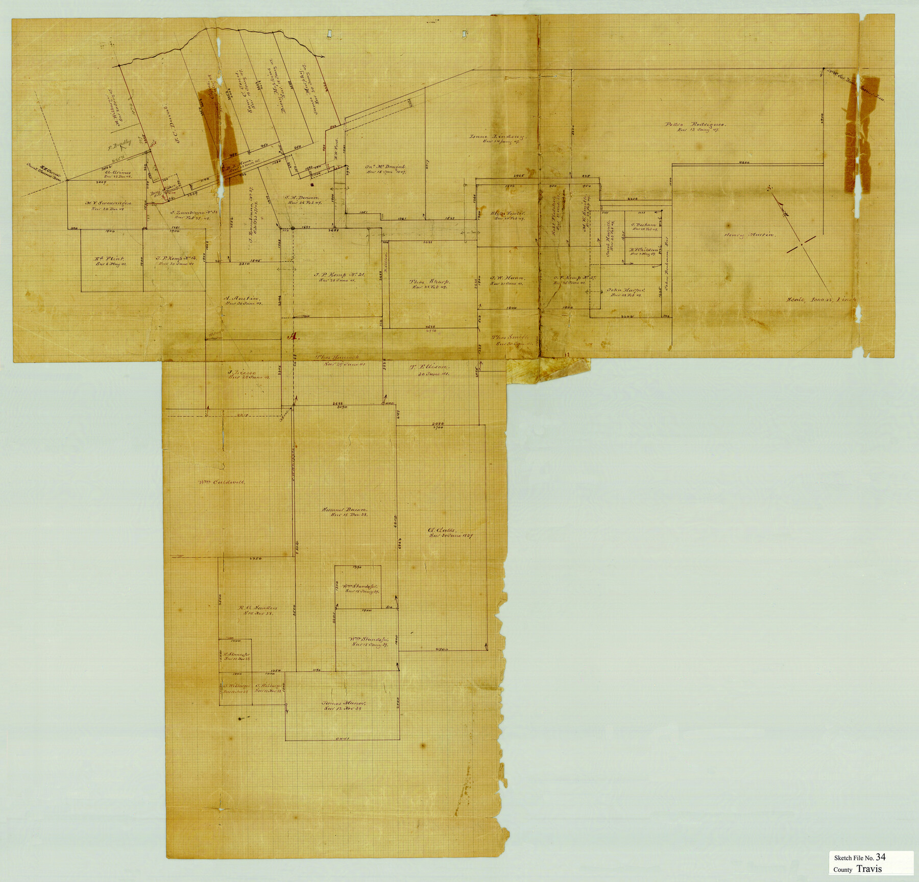
Travis County Sketch File 34
[Sketch and explanation regarding surveys in the northeast part of the county]
-
Map/Doc
12461
-
Collection
General Map Collection
-
Object Dates
8/30/1888 (Creation Date)
-
People and Organizations
Jno. E. Campbell (Surveyor/Engineer)
-
Counties
Travis
-
Subjects
Surveying Sketch File
-
Height x Width
26.8 x 27.9 inches
68.1 x 70.9 cm
-
Medium
van dyke/brownline/sepia
-
Scale
1" = 1000 varas
-
Features
Colorado River
Marshall Ford Dam
Part of: General Map Collection
Runnels County Sketch File 28

Print $6.00
Runnels County Sketch File 28
1949
Size 11.3 x 8.8 inches
Map/Doc 35493
Topographical Map of the Rio Grande, Sheet No. 8

Print $20.00
- Digital $50.00
Topographical Map of the Rio Grande, Sheet No. 8
1912
Map/Doc 89532
[Surveys in the Nacogdoches District, from the Sabine River to Cowleach Fork]
![282, [Surveys in the Nacogdoches District, from the Sabine River to Cowleach Fork], General Map Collection](https://historictexasmaps.com/wmedia_w700/maps/282.tif.jpg)
Print $3.00
- Digital $50.00
[Surveys in the Nacogdoches District, from the Sabine River to Cowleach Fork]
Size 15.6 x 11.5 inches
Map/Doc 282
Donley County Sketch File 12

Print $2.00
- Digital $50.00
Donley County Sketch File 12
Size 12.9 x 8.2 inches
Map/Doc 21248
Dimmit County Working Sketch 42

Print $20.00
- Digital $50.00
Dimmit County Working Sketch 42
1977
Size 33.5 x 39.6 inches
Map/Doc 68703
Flight Mission No. BRE-3P, Frame 38, Nueces County

Print $20.00
- Digital $50.00
Flight Mission No. BRE-3P, Frame 38, Nueces County
1956
Size 18.5 x 22.4 inches
Map/Doc 86816
Polk County Sketch File 23

Print $20.00
- Digital $50.00
Polk County Sketch File 23
Size 18.0 x 18.6 inches
Map/Doc 12191
Young County Sketch File 18

Print $10.00
- Digital $50.00
Young County Sketch File 18
1929
Size 11.5 x 8.7 inches
Map/Doc 40882
[Location Survey of the Southern Kansas Railway, Kiowa Extension from a point in Drake's Location, in Indian Territory 100 miles from south line of Kansas, continuing up Wolf Creek and South Canadian River to Cottonwood Creek in Hutchinson County]
![88845, [Location Survey of the Southern Kansas Railway, Kiowa Extension from a point in Drake's Location, in Indian Territory 100 miles from south line of Kansas, continuing up Wolf Creek and South Canadian River to Cottonwood Creek in Hutchinson County], General Map Collection](https://historictexasmaps.com/wmedia_w700/maps/88845.tif.jpg)
Print $20.00
- Digital $50.00
[Location Survey of the Southern Kansas Railway, Kiowa Extension from a point in Drake's Location, in Indian Territory 100 miles from south line of Kansas, continuing up Wolf Creek and South Canadian River to Cottonwood Creek in Hutchinson County]
1886
Size 37.5 x 36.0 inches
Map/Doc 88845
Ochiltree County Boundary File 5

Print $54.00
- Digital $50.00
Ochiltree County Boundary File 5
Size 9.3 x 8.3 inches
Map/Doc 57684
[Galveston, Harrisburg & San Antonio through El Paso County]
![64006, [Galveston, Harrisburg & San Antonio through El Paso County], General Map Collection](https://historictexasmaps.com/wmedia_w700/maps/64006.tif.jpg)
Print $20.00
- Digital $50.00
[Galveston, Harrisburg & San Antonio through El Paso County]
Size 13.5 x 33.7 inches
Map/Doc 64006
Flight Mission No. CGI-3N, Frame 148, Cameron County

Print $20.00
- Digital $50.00
Flight Mission No. CGI-3N, Frame 148, Cameron County
1954
Size 18.5 x 22.2 inches
Map/Doc 84621
You may also like
Controlled Mosaic by Jack Amman Photogrammetric Engineers, Inc - Sheet 19

Print $20.00
- Digital $50.00
Controlled Mosaic by Jack Amman Photogrammetric Engineers, Inc - Sheet 19
1954
Size 19.3 x 24.0 inches
Map/Doc 83465
Flight Mission No. CRK-7P, Frame 27, Refugio County

Print $20.00
- Digital $50.00
Flight Mission No. CRK-7P, Frame 27, Refugio County
1956
Size 18.3 x 22.1 inches
Map/Doc 86947
Kendall County Working Sketch 28a

Print $20.00
- Digital $50.00
Kendall County Working Sketch 28a
2006
Size 29.8 x 45.0 inches
Map/Doc 83097
South Sulphur River, Charleston Sheet

Print $20.00
- Digital $50.00
South Sulphur River, Charleston Sheet
1924
Size 16.6 x 18.0 inches
Map/Doc 78326
Aransas Pass to Baffin Bay

Print $20.00
- Digital $50.00
Aransas Pass to Baffin Bay
1981
Size 43.0 x 35.0 inches
Map/Doc 73420
Certified description of Houston & Gt. Northern Railrd. from Houston to Trinity River

Print $12.00
- Digital $50.00
Certified description of Houston & Gt. Northern Railrd. from Houston to Trinity River
1871
Size 12.9 x 7.9 inches
Map/Doc 64302

Map of Taylor, Bastrop & Houston Railroad in Williamson, Travis, & Bastrop Counties, Texas

Print $20.00
- Digital $50.00
Map of Taylor, Bastrop & Houston Railroad in Williamson, Travis, & Bastrop Counties, Texas
1887
Size 26.3 x 17.8 inches
Map/Doc 65468

Webb County Sketch File 14-1

Print $6.00
- Digital $50.00
Webb County Sketch File 14-1
1892
Size 14.4 x 9.1 inches
Map/Doc 39814
Duval County Working Sketch 15

Print $20.00
- Digital $50.00
Duval County Working Sketch 15
1938
Size 23.3 x 22.7 inches
Map/Doc 68728
Sabine River, Rocky Point Crossing Sheet

Print $4.00
- Digital $50.00
Sabine River, Rocky Point Crossing Sheet
Size 24.0 x 24.6 inches
Map/Doc 65134