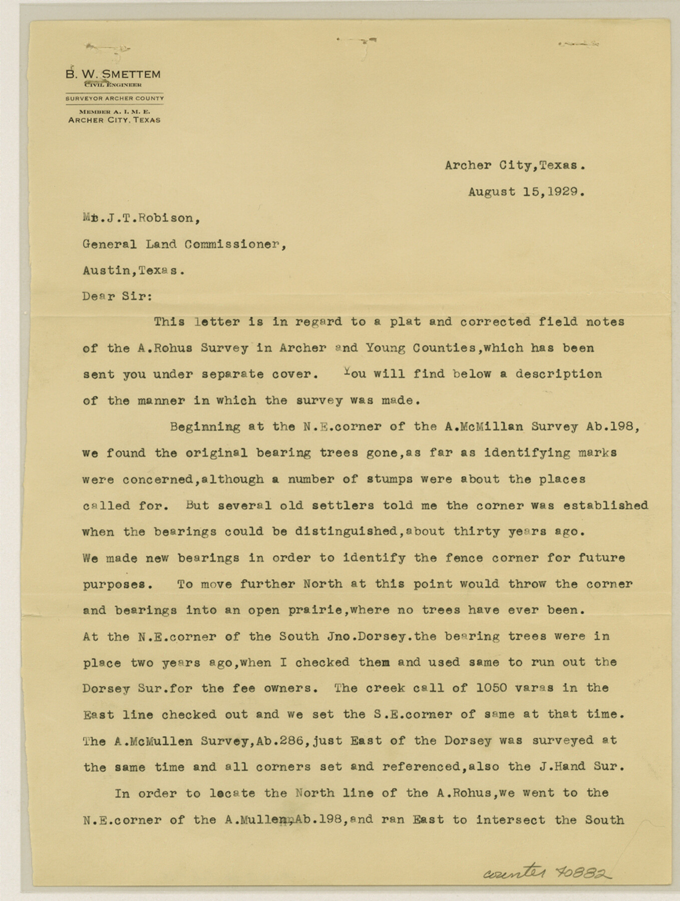
Young County Sketch File 18
[Connecting line and explanation of location of the A. Rohus survey in Young County]
-
Map/Doc
40882
-
Collection
General Map Collection
-
Object Dates
1929/8/15 (Creation Date)
1929/8/26 (File Date)
1929/8/15 (Creation Date)
1929/8/26 (File Date)
-
People and Organizations
B.W. Smettem (Surveyor/Engineer)
-
Counties
Young
-
Subjects
Surveying Sketch File
-
Height x Width
11.5 x 8.7 inches
29.2 x 22.1 cm
-
Medium
paper, print
-
Features
Public Road
West Fork of Trinity River
Part of: General Map Collection
Sterling County Working Sketch 6

Print $40.00
- Digital $50.00
Sterling County Working Sketch 6
1955
Size 38.1 x 121.6 inches
Map/Doc 63988
Duval County Rolled Sketch 51

Print $20.00
- Digital $50.00
Duval County Rolled Sketch 51
Size 19.1 x 16.9 inches
Map/Doc 5765
Harris County Working Sketch 73

Print $20.00
- Digital $50.00
Harris County Working Sketch 73
1959
Size 33.5 x 38.1 inches
Map/Doc 65965
Orange County Boundary File 7

Print $10.00
- Digital $50.00
Orange County Boundary File 7
Size 4.1 x 7.6 inches
Map/Doc 57775
[Map of the City of South Padre Island]
![3212, [Map of the City of South Padre Island], General Map Collection](https://historictexasmaps.com/wmedia_w700/maps/3212-1.tif.jpg)
Print $20.00
- Digital $50.00
[Map of the City of South Padre Island]
1993
Size 12.5 x 36.5 inches
Map/Doc 3212
Presidio County Rolled Sketch 145

Print $20.00
- Digital $50.00
Presidio County Rolled Sketch 145
2012
Size 36.6 x 24.5 inches
Map/Doc 93380
Hill County Sketch File 4

Print $8.00
- Digital $50.00
Hill County Sketch File 4
1859
Size 14.1 x 8.0 inches
Map/Doc 26464
Kerr County Sketch File 7

Print $4.00
- Digital $50.00
Kerr County Sketch File 7
1881
Size 8.8 x 15.7 inches
Map/Doc 28869
Hutchinson County

Print $20.00
- Digital $50.00
Hutchinson County
1922
Size 40.7 x 34.8 inches
Map/Doc 77321
University Lands Blocks 27 & 28, Pecos County

Print $20.00
- Digital $50.00
University Lands Blocks 27 & 28, Pecos County
1940
Size 33.6 x 21.1 inches
Map/Doc 2449
[Galveston, Harrisburg & San Antonio Railroad from Cuero to Stockdale]
![64189, [Galveston, Harrisburg & San Antonio Railroad from Cuero to Stockdale], General Map Collection](https://historictexasmaps.com/wmedia_w700/maps/64189.tif.jpg)
Print $20.00
- Digital $50.00
[Galveston, Harrisburg & San Antonio Railroad from Cuero to Stockdale]
1907
Size 13.8 x 34.0 inches
Map/Doc 64189
Edwards County Working Sketch 121

Print $20.00
- Digital $50.00
Edwards County Working Sketch 121
1976
Size 28.2 x 24.8 inches
Map/Doc 68997
You may also like
Location of the Southern Kansas Railway of Texas through Hemphill County, Texas

Print $40.00
- Digital $50.00
Location of the Southern Kansas Railway of Texas through Hemphill County, Texas
1887
Size 20.1 x 104.9 inches
Map/Doc 64034
Lipscomb County Rolled Sketch 5

Print $20.00
- Digital $50.00
Lipscomb County Rolled Sketch 5
1941
Size 45.8 x 23.3 inches
Map/Doc 9451
Hockley County Sketch File 15

Print $6.00
- Digital $50.00
Hockley County Sketch File 15
1912
Size 11.4 x 8.9 inches
Map/Doc 26550
Brewster County Rolled Sketch 19B

Print $40.00
- Digital $50.00
Brewster County Rolled Sketch 19B
1881
Size 48.5 x 39.4 inches
Map/Doc 8472
Stephens County Working Sketch 20

Print $20.00
- Digital $50.00
Stephens County Working Sketch 20
1972
Size 26.7 x 30.6 inches
Map/Doc 63963
Wise County Sketch File 8

Print $4.00
- Digital $50.00
Wise County Sketch File 8
1855
Size 12.2 x 7.8 inches
Map/Doc 40537
Flight Mission No. CUG-1P, Frame 167, Kleberg County

Print $20.00
- Digital $50.00
Flight Mission No. CUG-1P, Frame 167, Kleberg County
1956
Size 18.7 x 22.4 inches
Map/Doc 86174
Cameron County Rolled Sketch Z

Print $20.00
- Digital $50.00
Cameron County Rolled Sketch Z
1936
Size 24.6 x 31.3 inches
Map/Doc 5400
Maps of Gulf Intracoastal Waterway, Texas - Sabine River to the Rio Grande and connecting waterways including ship channels

Print $20.00
- Digital $50.00
Maps of Gulf Intracoastal Waterway, Texas - Sabine River to the Rio Grande and connecting waterways including ship channels
1966
Size 14.5 x 22.2 inches
Map/Doc 61920
Brewster County Working Sketch 77

Print $20.00
- Digital $50.00
Brewster County Working Sketch 77
1968
Size 25.0 x 20.9 inches
Map/Doc 67677
Eastland County Working Sketch 64

Print $40.00
- Digital $50.00
Eastland County Working Sketch 64
1983
Size 43.3 x 68.4 inches
Map/Doc 88891
Comanche County Sketch File 6

Print $4.00
- Digital $50.00
Comanche County Sketch File 6
1854
Size 12.7 x 8.4 inches
Map/Doc 19061