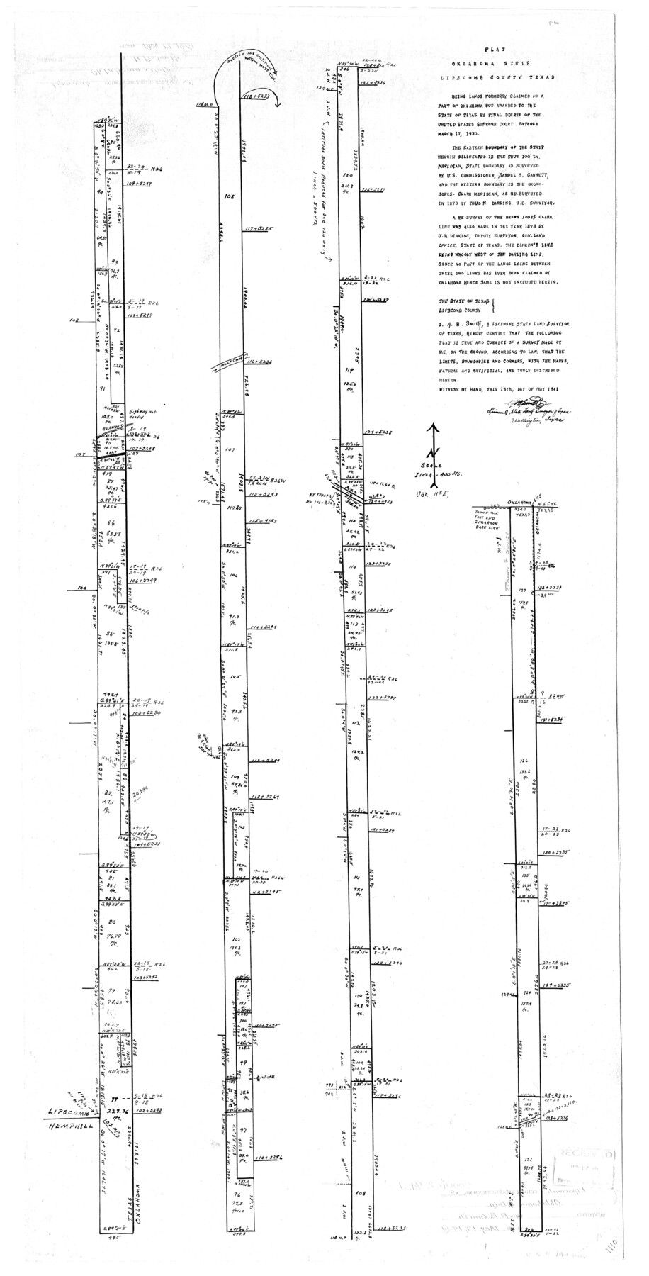
Lipscomb County Rolled Sketch 5
Plat, Oklahoma Strip, Lipscomb County, Texas
-
Map/Doc
9451
-
Collection
General Map Collection
-
Object Dates
1941/5/17 (File Date)
1941/5/13 (Creation Date)
-
People and Organizations
A.B. Smith (Surveyor/Engineer)
-
Counties
Lipscomb
-
Subjects
Surveying Rolled Sketch
-
Height x Width
45.8 x 23.3 inches
116.3 x 59.2 cm
Part of: General Map Collection
Hartley County Rolled Sketch 9

Print $20.00
- Digital $50.00
Hartley County Rolled Sketch 9
2001
Size 22.7 x 34.7 inches
Map/Doc 76407
Andrews County Sketch File 16

Print $12.00
- Digital $50.00
Andrews County Sketch File 16
1934
Size 11.2 x 8.8 inches
Map/Doc 12897
Flight Mission No. CRC-4R, Frame 105, Chambers County

Print $20.00
- Digital $50.00
Flight Mission No. CRC-4R, Frame 105, Chambers County
1956
Size 18.8 x 22.4 inches
Map/Doc 84902
Clay County Working Sketch 9

Print $20.00
- Digital $50.00
Clay County Working Sketch 9
1938
Size 37.5 x 29.4 inches
Map/Doc 68032
Leon County Rolled Sketch 6

Print $20.00
- Digital $50.00
Leon County Rolled Sketch 6
1951
Size 31.6 x 37.6 inches
Map/Doc 6597
Sketch D Showing the progress of Section IV 1845 to 1852

Print $20.00
- Digital $50.00
Sketch D Showing the progress of Section IV 1845 to 1852
1852
Size 22.8 x 13.0 inches
Map/Doc 97208
Harris County Working Sketch 1

Print $20.00
- Digital $50.00
Harris County Working Sketch 1
Size 15.8 x 15.8 inches
Map/Doc 65893
Real County Working Sketch 56

Print $20.00
- Digital $50.00
Real County Working Sketch 56
1960
Size 31.1 x 23.9 inches
Map/Doc 71948

Van Zandt County Boundary File 1

Print $32.00
- Digital $50.00
Van Zandt County Boundary File 1
Size 13.0 x 8.5 inches
Map/Doc 59626
Armstrong County Sketch File 8

Print $8.00
- Digital $50.00
Armstrong County Sketch File 8
Size 14.2 x 8.8 inches
Map/Doc 13705
Cottle County Working Sketch 16

Print $20.00
- Digital $50.00
Cottle County Working Sketch 16
1975
Size 24.5 x 21.6 inches
Map/Doc 68326
You may also like
Right of Way & Track Map, San Antonio & Aransas Pass Railway Co.

Print $40.00
- Digital $50.00
Right of Way & Track Map, San Antonio & Aransas Pass Railway Co.
1919
Size 25.3 x 56.7 inches
Map/Doc 64216
General Highway Map. Detail of Cities and Towns in Bexar County, Texas. City Map of San Antonio, Alamo Heights, Olmos Park, Terrell Hills, Castle Hills, Balcones Heights, and vicinity, Bexar County, Texas

Print $20.00
General Highway Map. Detail of Cities and Towns in Bexar County, Texas. City Map of San Antonio, Alamo Heights, Olmos Park, Terrell Hills, Castle Hills, Balcones Heights, and vicinity, Bexar County, Texas
1961
Size 18.1 x 25.1 inches
Map/Doc 79373

Harris County Sketch File 95

Print $20.00
- Digital $50.00
Harris County Sketch File 95
1952
Size 31.6 x 17.1 inches
Map/Doc 11678
Flight Mission No. DIX-6P, Frame 202, Aransas County

Print $20.00
- Digital $50.00
Flight Mission No. DIX-6P, Frame 202, Aransas County
1956
Size 19.2 x 22.7 inches
Map/Doc 83864
Bosque County Sketch File 11

Print $4.00
- Digital $50.00
Bosque County Sketch File 11
1863
Size 10.2 x 8.3 inches
Map/Doc 14759
Floyd County Sketch File 21

Print $20.00
- Digital $50.00
Floyd County Sketch File 21
1914
Size 30.0 x 23.2 inches
Map/Doc 11486
[Atchison, Topeka & Santa Fe from Paisano to south of Plata]
![64709, [Atchison, Topeka & Santa Fe from Paisano to south of Plata], General Map Collection](https://historictexasmaps.com/wmedia_w700/maps/64709.tif.jpg)
Print $40.00
- Digital $50.00
[Atchison, Topeka & Santa Fe from Paisano to south of Plata]
Size 32.3 x 120.8 inches
Map/Doc 64709
Galveston County Rolled Sketch Z61

Print $20.00
- Digital $50.00
Galveston County Rolled Sketch Z61
1934
Size 34.9 x 23.0 inches
Map/Doc 5993
Flight Mission No. CRE-2R, Frame 89, Jackson County

Print $20.00
- Digital $50.00
Flight Mission No. CRE-2R, Frame 89, Jackson County
1956
Size 18.6 x 22.2 inches
Map/Doc 85361
Dallas County Sketch File 6

Print $20.00
- Digital $50.00
Dallas County Sketch File 6
1850
Size 19.9 x 25.1 inches
Map/Doc 11283
Loving County Sketch File 4

Print $40.00
- Digital $50.00
Loving County Sketch File 4
1961
Size 20.6 x 24.7 inches
Map/Doc 12014