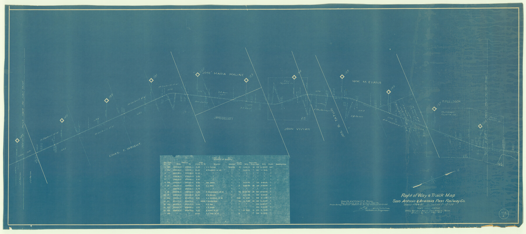
Right of Way & Track Map, San Antonio & Aransas Pass Railway Co.
Station 1584+00 to Station 2112+00
Z-2-55
-
Map/Doc
64216
-
Collection
General Map Collection
-
Object Dates
1919 (Creation Date)
-
People and Organizations
Office Valuation Board (Publisher)
-
Counties
Fayette
-
Subjects
Railroads
-
Height x Width
25.3 x 56.7 inches
64.3 x 144.0 cm
-
Medium
blueprint/diazo
-
Scale
1 inch = 1000 feet
-
Comments
See counters 64213 through 64218 for all pages of map.
-
Features
SA&AP
Floy
Muldoon
Part of: General Map Collection
Tom Green County Sketch File 41

Print $8.00
- Digital $50.00
Tom Green County Sketch File 41
1884
Size 12.8 x 8.3 inches
Map/Doc 38196
Menard County Sketch File 24

Print $20.00
- Digital $50.00
Menard County Sketch File 24
1932
Size 17.0 x 26.5 inches
Map/Doc 12077
Nueces County NRC Article 33.136 Sketch 22

Print $42.00
Nueces County NRC Article 33.136 Sketch 22
2023
Map/Doc 97180
Tyler County Rolled Sketch 11

Print $20.00
- Digital $50.00
Tyler County Rolled Sketch 11
Size 34.2 x 36.4 inches
Map/Doc 10033
Pecos County Rolled Sketch 56

Print $20.00
- Digital $50.00
Pecos County Rolled Sketch 56
1916
Size 18.1 x 24.2 inches
Map/Doc 5229
Wilbarger County Working Sketch 13

Print $20.00
- Digital $50.00
Wilbarger County Working Sketch 13
1954
Size 25.9 x 24.0 inches
Map/Doc 72551
Montague County Boundary File 3

Print $42.00
- Digital $50.00
Montague County Boundary File 3
Size 9.0 x 13.6 inches
Map/Doc 57434
Terrell County Working Sketch 13

Print $20.00
- Digital $50.00
Terrell County Working Sketch 13
1926
Size 30.1 x 22.8 inches
Map/Doc 62162
Palo Pinto County Rolled Sketch 7

Print $20.00
- Digital $50.00
Palo Pinto County Rolled Sketch 7
Size 27.3 x 34.2 inches
Map/Doc 7190
United States - Gulf Coast - From Latitude 26° 33' to the Rio Grande Texas

Print $20.00
- Digital $50.00
United States - Gulf Coast - From Latitude 26° 33' to the Rio Grande Texas
1913
Size 27.8 x 18.4 inches
Map/Doc 72831
[Sketch for Mineral Application 16696-16697, Pecos River]
![65614, [Sketch for Mineral Application 16696-16697, Pecos River], General Map Collection](https://historictexasmaps.com/wmedia_w700/maps/65614.tif.jpg)
Print $40.00
- Digital $50.00
[Sketch for Mineral Application 16696-16697, Pecos River]
Size 42.6 x 69.4 inches
Map/Doc 65614
Concho County Working Sketch 25

Print $20.00
- Digital $50.00
Concho County Working Sketch 25
1982
Size 32.3 x 38.1 inches
Map/Doc 68207
You may also like
Bird's Eye View of the City of Gainesville Cooke County, Texas

Print $20.00
Bird's Eye View of the City of Gainesville Cooke County, Texas
1883
Size 19.2 x 25.6 inches
Map/Doc 89084
Coke County Sketch File 12

Print $8.00
- Digital $50.00
Coke County Sketch File 12
Size 9.4 x 8.0 inches
Map/Doc 18592
Rusk County Sketch File Z

Print $6.00
Rusk County Sketch File Z
1850
Size 15.8 x 9.0 inches
Map/Doc 35539
Wharton County Working Sketch 3

Print $20.00
- Digital $50.00
Wharton County Working Sketch 3
Size 17.5 x 16.4 inches
Map/Doc 72467
Dimmit County Sketch File 60

Print $4.00
- Digital $50.00
Dimmit County Sketch File 60
1991
Size 14.2 x 8.8 inches
Map/Doc 21206
Pecos County Working Sketch 67

Print $20.00
- Digital $50.00
Pecos County Working Sketch 67
1955
Size 17.7 x 18.7 inches
Map/Doc 71539
Map of Terry County

Print $20.00
- Digital $50.00
Map of Terry County
Size 26.5 x 27.8 inches
Map/Doc 92908
Shelby County Rolled Sketch 10

Print $20.00
- Digital $50.00
Shelby County Rolled Sketch 10
Size 16.2 x 27.3 inches
Map/Doc 7778
Kerr County Sketch File 5

Print $4.00
- Digital $50.00
Kerr County Sketch File 5
1878
Size 14.2 x 8.4 inches
Map/Doc 28865
Grayson County Working Sketch 5

Print $20.00
- Digital $50.00
Grayson County Working Sketch 5
1939
Size 28.4 x 40.6 inches
Map/Doc 63244
General Highway Map, Fort Bend County, Texas

Print $20.00
General Highway Map, Fort Bend County, Texas
1961
Size 18.1 x 24.5 inches
Map/Doc 79469
Flight Mission No. DCL-6C, Frame 18, Kenedy County

Print $20.00
- Digital $50.00
Flight Mission No. DCL-6C, Frame 18, Kenedy County
1943
Size 18.6 x 22.5 inches
Map/Doc 85875