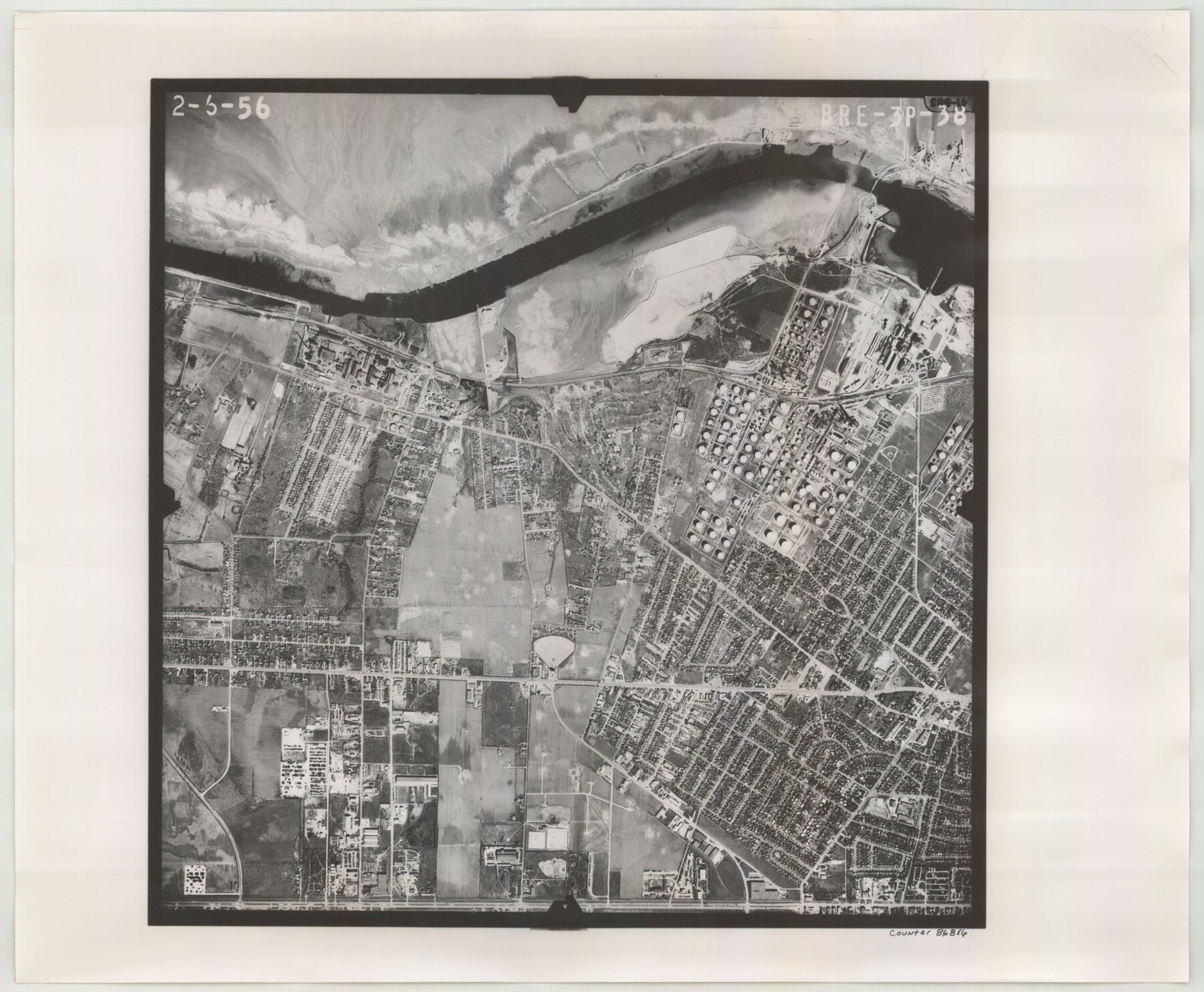
Flight Mission No. BRE-3P, Frame 38, Nueces County
BRE-3P-38
-
Map/Doc
86816
-
Collection
General Map Collection
-
Object Dates
1956/2/6 (Creation Date)
-
People and Organizations
U. S. Department of Agriculture (Publisher)
-
Counties
Nueces
-
Subjects
Aerial Photograph
-
Height x Width
18.5 x 22.4 inches
47.0 x 56.9 cm
-
Comments
Flown by V. L. Beavers and Associates of San Antonio, Texas.
Part of: General Map Collection
[Sketch for Mineral Application 36425 - Jefferson County, Ley C. Moore]
![65615, [Sketch for Mineral Application 36425 - Jefferson County, Ley C. Moore], General Map Collection](https://historictexasmaps.com/wmedia_w700/maps/65615.tif.jpg)
Print $40.00
- Digital $50.00
[Sketch for Mineral Application 36425 - Jefferson County, Ley C. Moore]
1942
Size 35.0 x 49.3 inches
Map/Doc 65615
Jefferson County Rolled Sketch 60

Print $40.00
- Digital $50.00
Jefferson County Rolled Sketch 60
Size 56.1 x 34.7 inches
Map/Doc 9317
Fifteenth Census 1930 Population - Texas

Print $20.00
- Digital $50.00
Fifteenth Census 1930 Population - Texas
1930
Size 19.5 x 22.6 inches
Map/Doc 2146
USGS Topographic, De Kalb NW, Texas Quadrangle

Print $20.00
- Digital $50.00
USGS Topographic, De Kalb NW, Texas Quadrangle
1950
Size 26.8 x 21.6 inches
Map/Doc 77604
Flight Mission No. CRC-2R, Frame 192, Chambers County

Print $20.00
- Digital $50.00
Flight Mission No. CRC-2R, Frame 192, Chambers County
1956
Size 18.6 x 22.3 inches
Map/Doc 84770
Guadalupe County Sketch File 3a

Print $4.00
- Digital $50.00
Guadalupe County Sketch File 3a
1849
Size 10.7 x 8.2 inches
Map/Doc 24652
Wheeler County Boundary File 1

Print $24.00
- Digital $50.00
Wheeler County Boundary File 1
Size 14.4 x 8.7 inches
Map/Doc 59856
[Surveys in Austin's Colony along the Yegua River and Cedar Creek]
![67, [Surveys in Austin's Colony along the Yegua River and Cedar Creek], General Map Collection](https://historictexasmaps.com/wmedia_w700/maps/67.tif.jpg)
Print $20.00
- Digital $50.00
[Surveys in Austin's Colony along the Yegua River and Cedar Creek]
1835
Size 15.7 x 19.3 inches
Map/Doc 67
Brooks County Rolled Sketch 22

Print $20.00
- Digital $50.00
Brooks County Rolled Sketch 22
1943
Size 15.1 x 32.2 inches
Map/Doc 5343
Nueces River, Corpus Christi Sheet No. 3

Print $6.00
- Digital $50.00
Nueces River, Corpus Christi Sheet No. 3
1938
Size 31.7 x 25.9 inches
Map/Doc 65091
Palo Pinto County

Print $20.00
- Digital $50.00
Palo Pinto County
1896
Size 27.2 x 22.1 inches
Map/Doc 3937
Tarrant County Sketch File 12

Print $4.00
- Digital $50.00
Tarrant County Sketch File 12
1859
Size 10.1 x 8.3 inches
Map/Doc 37703
You may also like
Loving County Working Sketch 11

Print $40.00
- Digital $50.00
Loving County Working Sketch 11
1957
Size 21.6 x 50.9 inches
Map/Doc 70644
[E. L. & R. R. RR. Co. Block D7 and G. H. & H. RR. Co. Block A1]
![91860, [E. L. & R. R. RR. Co. Block D7 and G. H. & H. RR. Co. Block A1], Twichell Survey Records](https://historictexasmaps.com/wmedia_w700/maps/91860-1.tif.jpg)
Print $20.00
- Digital $50.00
[E. L. & R. R. RR. Co. Block D7 and G. H. & H. RR. Co. Block A1]
Size 18.7 x 26.7 inches
Map/Doc 91860
Yoakum County Rolled Sketch 5

Print $20.00
- Digital $50.00
Yoakum County Rolled Sketch 5
1992
Size 20.9 x 16.3 inches
Map/Doc 8290
Texas Coast, No. 17

Print $20.00
- Digital $50.00
Texas Coast, No. 17
Size 18.3 x 27.6 inches
Map/Doc 72712
Yoakum County Sketch File 8

Print $20.00
- Digital $50.00
Yoakum County Sketch File 8
Size 25.6 x 29.3 inches
Map/Doc 12705
Falls County Working Sketch Graphic Index

Print $20.00
- Digital $50.00
Falls County Working Sketch Graphic Index
1976
Size 39.7 x 44.2 inches
Map/Doc 76539
[Surveys in Austin's Colony along the Brazos River]
![213, [Surveys in Austin's Colony along the Brazos River], General Map Collection](https://historictexasmaps.com/wmedia_w700/maps/213.tif.jpg)
Print $20.00
- Digital $50.00
[Surveys in Austin's Colony along the Brazos River]
1824
Size 12.9 x 14.5 inches
Map/Doc 213
Midland County Sketch File 17

Print $26.00
- Digital $50.00
Midland County Sketch File 17
1955
Size 11.2 x 8.7 inches
Map/Doc 31582
Montgomery County Working Sketch 3

Print $20.00
- Digital $50.00
Montgomery County Working Sketch 3
1918
Size 16.5 x 14.1 inches
Map/Doc 71109
San Augustine County Sketch File 9

Print $4.00
San Augustine County Sketch File 9
1860
Size 12.6 x 7.6 inches
Map/Doc 35650
Bee County Sketch File 18

Print $6.00
- Digital $50.00
Bee County Sketch File 18
1880
Size 11.8 x 10.3 inches
Map/Doc 14303
Nueces County

Print $20.00
- Digital $50.00
Nueces County
1913
Size 25.9 x 34.9 inches
Map/Doc 73252