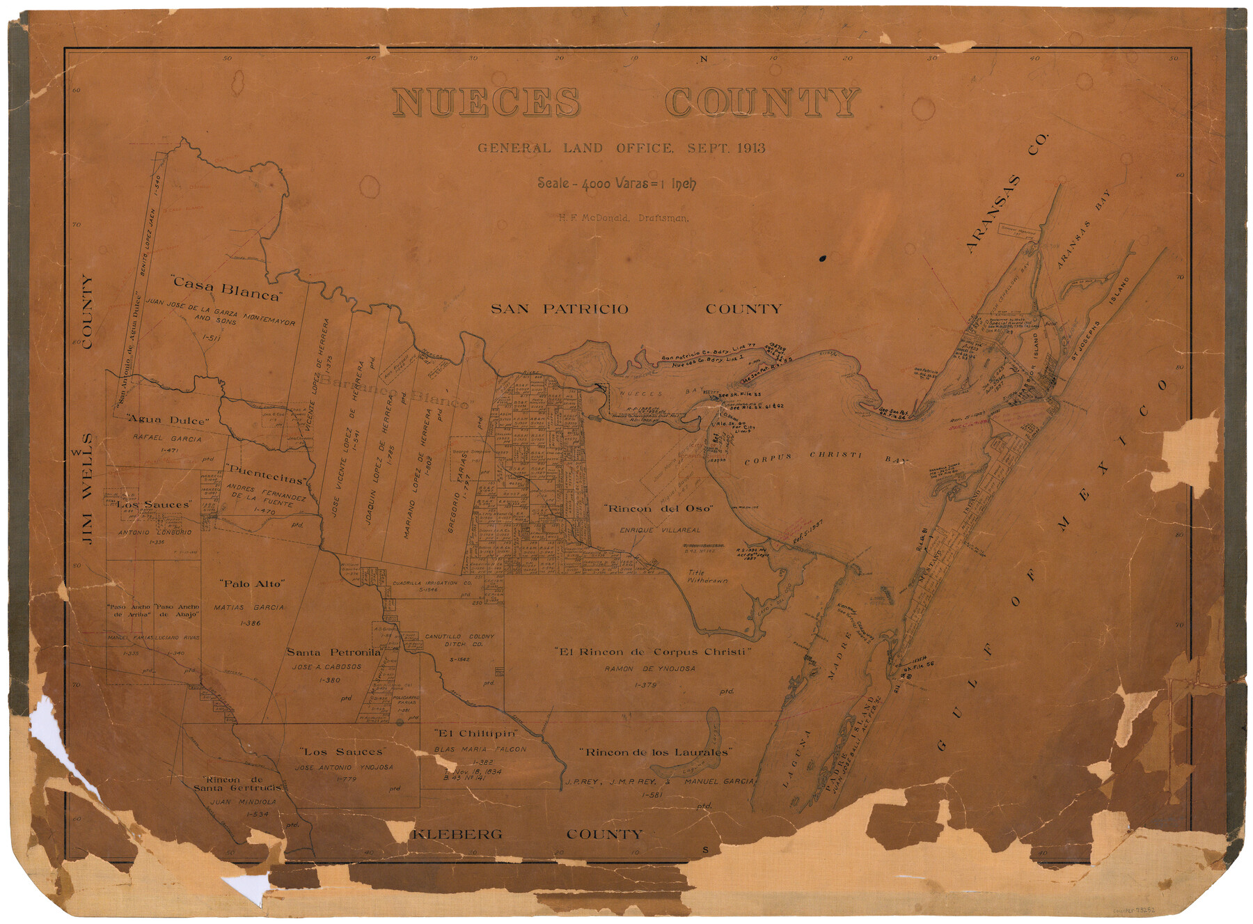
Nueces County
-
Map/Doc
73252
-
Collection
General Map Collection
-
Object Dates
1913 (Creation Date)
-
People and Organizations
Texas General Land Office (Publisher)
H.F. McDonald (Compiler)
H.F. McDonald (Draftsman)
-
Counties
Nueces
-
Subjects
County
-
Height x Width
25.9 x 34.9 inches
65.8 x 88.6 cm
-
Comments
Hand lettered.
Note on reverse side: "Compilated and drawn by H. F. McDonald. Completed September 2, 1913. Area: 1108 Square Miles." -
Features
Santa Gertrudis Creek
Shoal Bay
Ransoms Point
Paloma
Steadman Island
Harbor Island
Lydia Ann Islands
St. Josephs Island
Peñetes Creek
Murray's Island
Ship Island
Hog Island
Donnels Reef
Padre Island
South Bird Island
North Bird Island
Laguna Larga
Tranquitas Creek
Acero Creek
San Fernando Creek
Carreta Creek
Bishop
Pintas Creek
Peat Island
Aransas Pass
Shell Island
Banquette
Clarksville
Shallow Bay
Kingsville
Mud Island
Shell Point
Crane Islands
Agua Dulce
Clarkwood
Bentonville
Corpus Christi Pass
TMRR
Turtle Cove
Port Aransas
Dagger Island
Red Fish Cove
Robstown
Puente Citos
Rosita Creek
Calallen
Ingleside Cove
Gregory Junction
Casa Blanca
Orange Grove
Sandy Hollow Creek
Leon Creek
Quinto Creek
La Fruta
Nueces River
Nuecestown
Nueces Bay
Whites Point
Shamrock Point
Reynolds
Aransas Pass
Corpus Christi Bayou
Shell Bank Island
SA&AP
Fish Bay
Taylor Islands
Tally Island
Aransas Bay
Rockport
Sandia
Mud Reef
Mustang Island
Laguna Madre
Driscoll
Portland
Chiltipin Creek
Santa Petronia Creek
SLB&M
Oso Creek
Cayo del Oso
Dimmits Island
Flour Bluff Point
Gulf of Mexico
Penites Creek
Shamrock Cove
Shamrock Island
Corpus Christi Bay
McGloins Bluff
Corpus Christi
Ringon [sic] Point
Red Fish Bay
Agua Dulce Creek
San Patricio
Petronia Creek
Part of: General Map Collection
Crosby County Working Sketch 14

Print $20.00
- Digital $50.00
Crosby County Working Sketch 14
1976
Size 41.6 x 32.3 inches
Map/Doc 68448
Wheeler County Working Sketch 1

Print $40.00
- Digital $50.00
Wheeler County Working Sketch 1
1940
Size 52.5 x 28.7 inches
Map/Doc 72490
Origin of Exports, Destination of Imports at Texas City, Tex. during 1921

Print $20.00
- Digital $50.00
Origin of Exports, Destination of Imports at Texas City, Tex. during 1921
1921
Size 13.8 x 9.6 inches
Map/Doc 97162
Pecos County Working Sketch 41

Print $20.00
- Digital $50.00
Pecos County Working Sketch 41
1942
Size 19.0 x 31.7 inches
Map/Doc 71513
Flight Mission No. DQO-11K, Frame 24, Galveston County

Print $20.00
- Digital $50.00
Flight Mission No. DQO-11K, Frame 24, Galveston County
1952
Size 18.6 x 22.4 inches
Map/Doc 85221

Right of Way & Track Map, San Antonio & Aransas Pass Railway Co.

Print $40.00
- Digital $50.00
Right of Way & Track Map, San Antonio & Aransas Pass Railway Co.
1919
Size 25.3 x 56.7 inches
Map/Doc 64216
Texas Official Travel Map

Digital $50.00
Texas Official Travel Map
Size 33.6 x 36.5 inches
Map/Doc 94301
Sherman County Boundary File 2a

Print $10.00
- Digital $50.00
Sherman County Boundary File 2a
Size 12.9 x 8.9 inches
Map/Doc 58768
McMullen County Sketch File 7

Print $40.00
- Digital $50.00
McMullen County Sketch File 7
1859
Size 19.1 x 11.6 inches
Map/Doc 31347
Flight Mission No. DQO-2K, Frame 92, Galveston County

Print $20.00
- Digital $50.00
Flight Mission No. DQO-2K, Frame 92, Galveston County
1952
Size 18.8 x 22.5 inches
Map/Doc 85019
Galveston County Sketch File 17

Print $2.00
- Digital $50.00
Galveston County Sketch File 17
1893
Size 10.5 x 8.9 inches
Map/Doc 23387
You may also like
Flight Mission No. CUG-3P, Frame 90, Kleberg County

Print $20.00
- Digital $50.00
Flight Mission No. CUG-3P, Frame 90, Kleberg County
1956
Size 18.6 x 22.3 inches
Map/Doc 86260
Kerr County Sketch File 5

Print $4.00
- Digital $50.00
Kerr County Sketch File 5
1878
Size 14.2 x 8.4 inches
Map/Doc 28865
Map of sections 1 & 2 of a survey of Padre Island made for the Office of the Attorney General of the State of Texas

Print $20.00
- Digital $50.00
Map of sections 1 & 2 of a survey of Padre Island made for the Office of the Attorney General of the State of Texas
1941
Size 40.8 x 39.8 inches
Map/Doc 2258
Flight Mission No. DAG-23K, Frame 182, Matagorda County

Print $20.00
- Digital $50.00
Flight Mission No. DAG-23K, Frame 182, Matagorda County
1953
Size 18.5 x 22.3 inches
Map/Doc 86517
Midland County Boundary File 5

Print $6.00
- Digital $50.00
Midland County Boundary File 5
Size 9.6 x 6.0 inches
Map/Doc 57195
Houston County Sketch File 4a

Print $4.00
- Digital $50.00
Houston County Sketch File 4a
1858
Size 13.0 x 8.3 inches
Map/Doc 26754
Real County Working Sketch 27

Print $20.00
- Digital $50.00
Real County Working Sketch 27
1947
Size 29.8 x 29.2 inches
Map/Doc 71919
Crane County Rolled Sketch 29

Print $20.00
- Digital $50.00
Crane County Rolled Sketch 29
2024
Size 24.6 x 35.5 inches
Map/Doc 97338
The Republic County of Colorado. May 24, 1838

Print $20.00
The Republic County of Colorado. May 24, 1838
2020
Size 18.4 x 21.7 inches
Map/Doc 96121
General Highway Map, Nacogdoches County, Texas

Print $20.00
General Highway Map, Nacogdoches County, Texas
1961
Size 19.3 x 25.0 inches
Map/Doc 79606
Nacogdoches County Sketch File 4

Print $4.00
- Digital $50.00
Nacogdoches County Sketch File 4
1858
Size 10.0 x 7.8 inches
Map/Doc 32241
