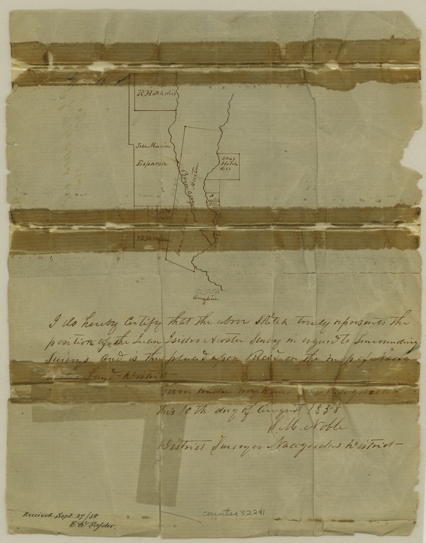
Nacogdoches County Sketch File 4
[Sketch southwest of Nacogdoches]
-
Map/Doc
32241
-
Collection
General Map Collection
-
Object Dates
8/10/1858 (Creation Date)
9/27/1858 (File Date)
-
People and Organizations
S.M. Noble (Surveyor/Engineer)
-
Counties
Nacogdoches
-
Subjects
Surveying Sketch File
-
Height x Width
10.0 x 7.8 inches
25.4 x 19.8 cm
-
Medium
paper, manuscript
-
Features
Bayou Attayon
Part of: General Map Collection
Haskell County Sketch File 5

Print $4.00
- Digital $50.00
Haskell County Sketch File 5
1856
Size 10.1 x 8.1 inches
Map/Doc 26124
Kinney County Working Sketch 20

Print $20.00
- Digital $50.00
Kinney County Working Sketch 20
1948
Size 31.3 x 24.3 inches
Map/Doc 70202
Harris County Rolled Sketch 74

Print $20.00
- Digital $50.00
Harris County Rolled Sketch 74
Size 19.1 x 33.3 inches
Map/Doc 6112
Reeves County Working Sketch 64

Print $20.00
- Digital $50.00
Reeves County Working Sketch 64
1984
Size 26.3 x 26.5 inches
Map/Doc 63507
Hutchinson County Sketch File 6a

Print $42.00
- Digital $50.00
Hutchinson County Sketch File 6a
1898
Size 7.6 x 8.6 inches
Map/Doc 27202
West Part of Liberty Co.

Print $20.00
- Digital $50.00
West Part of Liberty Co.
1977
Size 43.5 x 32.9 inches
Map/Doc 77353
1968 Texas Official State Highway Map

Digital $50.00
1968 Texas Official State Highway Map
Size 28.2 x 36.3 inches
Map/Doc 94320
Harris County Working Sketch 94

Print $20.00
- Digital $50.00
Harris County Working Sketch 94
1978
Size 20.9 x 40.2 inches
Map/Doc 65986
El Paso County Boundary File 20

Print $9.00
- Digital $50.00
El Paso County Boundary File 20
Size 13.2 x 8.3 inches
Map/Doc 53210
St. L. S-W. Ry. of Texas Map of Lufkin Branch in Angelina County, Texas

Print $20.00
- Digital $50.00
St. L. S-W. Ry. of Texas Map of Lufkin Branch in Angelina County, Texas
1913
Size 24.0 x 12.1 inches
Map/Doc 64562
Hill County Boundary File 45c

Print $64.00
- Digital $50.00
Hill County Boundary File 45c
Size 14.5 x 8.8 inches
Map/Doc 54784
Nautical Chart 885-SC Intracoastal Waterway - Ellender to Galveston Bay, Louisiana-Texas

Print $40.00
- Digital $50.00
Nautical Chart 885-SC Intracoastal Waterway - Ellender to Galveston Bay, Louisiana-Texas
1972
Size 16.4 x 60.1 inches
Map/Doc 69835
You may also like
Culberson County Working Sketch 4

Print $20.00
- Digital $50.00
Culberson County Working Sketch 4
Size 37.7 x 32.2 inches
Map/Doc 68456
Gray County Sketch File B2

Print $20.00
- Digital $50.00
Gray County Sketch File B2
Size 22.8 x 17.3 inches
Map/Doc 11579

Anderson County Working Sketch 25

Print $20.00
- Digital $50.00
Anderson County Working Sketch 25
1958
Size 33.1 x 36.6 inches
Map/Doc 67025
Foard County Sketch File 32

Print $4.00
- Digital $50.00
Foard County Sketch File 32
1950
Size 14.5 x 9.0 inches
Map/Doc 22864
Gulf Oil Corp. Fishgide - Freeport

Gulf Oil Corp. Fishgide - Freeport
1960
Size 12.1 x 22.1 inches
Map/Doc 75979
Flight Mission No. DQN-1K, Frame 117, Calhoun County

Print $20.00
- Digital $50.00
Flight Mission No. DQN-1K, Frame 117, Calhoun County
1953
Size 18.5 x 22.2 inches
Map/Doc 84183
Baker Addition to Lamesa, Part of Southwest Quarter Section 71, Block 35

Print $20.00
- Digital $50.00
Baker Addition to Lamesa, Part of Southwest Quarter Section 71, Block 35
Size 23.8 x 19.5 inches
Map/Doc 92576
Galveston County Rolled Sketch 34C

Print $20.00
- Digital $50.00
Galveston County Rolled Sketch 34C
1978
Size 29.0 x 40.8 inches
Map/Doc 5969
Stremme General Land Office Drawings, front view

Print $20.00
Stremme General Land Office Drawings, front view
Size 14.0 x 20.8 inches
Map/Doc 79738
Hutchinson County Working Sketch 21

Print $20.00
- Digital $50.00
Hutchinson County Working Sketch 21
1965
Size 35.0 x 40.8 inches
Map/Doc 66381
[W. S. Mabry's maps in south part of Oldham County]
![93065, [W. S. Mabry's maps in south part of Oldham County], Twichell Survey Records](https://historictexasmaps.com/wmedia_w700/maps/93065-1.tif.jpg)
Print $20.00
- Digital $50.00
[W. S. Mabry's maps in south part of Oldham County]
Size 40.4 x 15.8 inches
Map/Doc 93065