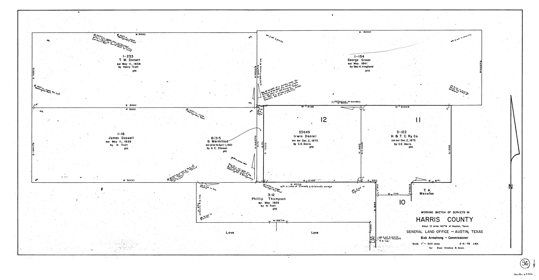
Harris County Working Sketch 94
-
Map/Doc
65986
-
Collection
General Map Collection
-
Object Dates
2/2/1978 (Creation Date)
-
People and Organizations
Joan Kilpatrick (Draftsman)
-
Counties
Harris
-
Subjects
Surveying Working Sketch
-
Height x Width
20.9 x 40.2 inches
53.1 x 102.1 cm
-
Scale
1" = 300 varas
Part of: General Map Collection
Burleson County Working Sketch 36

Print $20.00
- Digital $50.00
Burleson County Working Sketch 36
1982
Size 31.0 x 33.3 inches
Map/Doc 67755
Surveys in Reeves and Culberson Counties, Texas and Pacific Railroad Company, Blocks 58, 59, 60, and 61

Print $20.00
- Digital $50.00
Surveys in Reeves and Culberson Counties, Texas and Pacific Railroad Company, Blocks 58, 59, 60, and 61
1937
Size 30.7 x 25.3 inches
Map/Doc 2250
Flight Mission No. DIX-10P, Frame 82, Aransas County

Print $20.00
- Digital $50.00
Flight Mission No. DIX-10P, Frame 82, Aransas County
1956
Size 18.8 x 22.4 inches
Map/Doc 83943
Culberson County Rolled Sketch 65

Print $20.00
- Digital $50.00
Culberson County Rolled Sketch 65
1987
Size 23.7 x 18.8 inches
Map/Doc 5681
McCulloch County Boundary File 1

Print $40.00
- Digital $50.00
McCulloch County Boundary File 1
Size 9.2 x 33.6 inches
Map/Doc 56906
La Salle County

Print $20.00
- Digital $50.00
La Salle County
1886
Size 25.4 x 21.3 inches
Map/Doc 3795
Red River County Sketch File 5a

Print $2.00
- Digital $50.00
Red River County Sketch File 5a
Size 4.7 x 6.6 inches
Map/Doc 35104
Montgomery County Working Sketch 62

Print $20.00
- Digital $50.00
Montgomery County Working Sketch 62
1963
Size 18.1 x 21.3 inches
Map/Doc 71169
Township 6 North Range 13 West, North Western District, Louisiana

Print $20.00
- Digital $50.00
Township 6 North Range 13 West, North Western District, Louisiana
1841
Size 19.7 x 24.8 inches
Map/Doc 65864
Matagorda County Working Sketch 26

Print $20.00
- Digital $50.00
Matagorda County Working Sketch 26
1979
Size 14.1 x 19.5 inches
Map/Doc 70884
Grayson County Sketch File 23

Print $4.00
- Digital $50.00
Grayson County Sketch File 23
1872
Size 9.1 x 10.3 inches
Map/Doc 24503
Trinity County Sketch File 17

Print $4.00
- Digital $50.00
Trinity County Sketch File 17
Size 8.0 x 7.4 inches
Map/Doc 38546
You may also like
Colton's United States shewing the military stations, forts, &c

Print $20.00
Colton's United States shewing the military stations, forts, &c
1861
Size 14.6 x 17.3 inches
Map/Doc 93565
Llano County Working Sketch 14

Print $20.00
- Digital $50.00
Llano County Working Sketch 14
1989
Size 14.6 x 34.7 inches
Map/Doc 70632
Galveston County NRC Article 33.136 Sketch 18

Print $66.00
- Digital $50.00
Galveston County NRC Article 33.136 Sketch 18
2003
Size 22.4 x 33.9 inches
Map/Doc 78545
Coast Chart No. 210 Aransas Pass and Corpus Christi Bay with the coast to latitude 27° 12' Texas

Print $20.00
- Digital $50.00
Coast Chart No. 210 Aransas Pass and Corpus Christi Bay with the coast to latitude 27° 12' Texas
1887
Size 27.5 x 18.3 inches
Map/Doc 72787
Coast of Texas from head of East Bay Galveston Harbor to Sabine Pass

Print $40.00
- Digital $50.00
Coast of Texas from head of East Bay Galveston Harbor to Sabine Pass
1882
Size 32.2 x 54.1 inches
Map/Doc 69839
Val Verde County Working Sketch Graphic Index, Sheet 2 (Sketches 26 to 88)

Print $20.00
- Digital $50.00
Val Verde County Working Sketch Graphic Index, Sheet 2 (Sketches 26 to 88)
1944
Size 40.3 x 36.4 inches
Map/Doc 76725
Duval County Sketch File 46

Print $4.00
- Digital $50.00
Duval County Sketch File 46
Size 8.8 x 9.4 inches
Map/Doc 21400
Hemphill County Sketch File 4

Print $14.00
- Digital $50.00
Hemphill County Sketch File 4
1903
Size 14.1 x 8.7 inches
Map/Doc 26288
[Missouri, Kansas & Texas Line Map through Bastrop County]
![64031, [Missouri, Kansas & Texas Line Map through Bastrop County], General Map Collection](https://historictexasmaps.com/wmedia_w700/maps/64031.tif.jpg)
Print $40.00
- Digital $50.00
[Missouri, Kansas & Texas Line Map through Bastrop County]
1916
Size 26.5 x 124.4 inches
Map/Doc 64031
Nueces County Rolled Sketch 27A

Print $40.00
- Digital $50.00
Nueces County Rolled Sketch 27A
1946
Size 11.6 x 52.4 inches
Map/Doc 76042
Kendall County Boundary File 1

Print $6.00
- Digital $50.00
Kendall County Boundary File 1
Size 14.2 x 8.7 inches
Map/Doc 55743
Montgomery County Sketch File 12

Print $2.00
- Digital $50.00
Montgomery County Sketch File 12
Size 8.1 x 3.8 inches
Map/Doc 31802