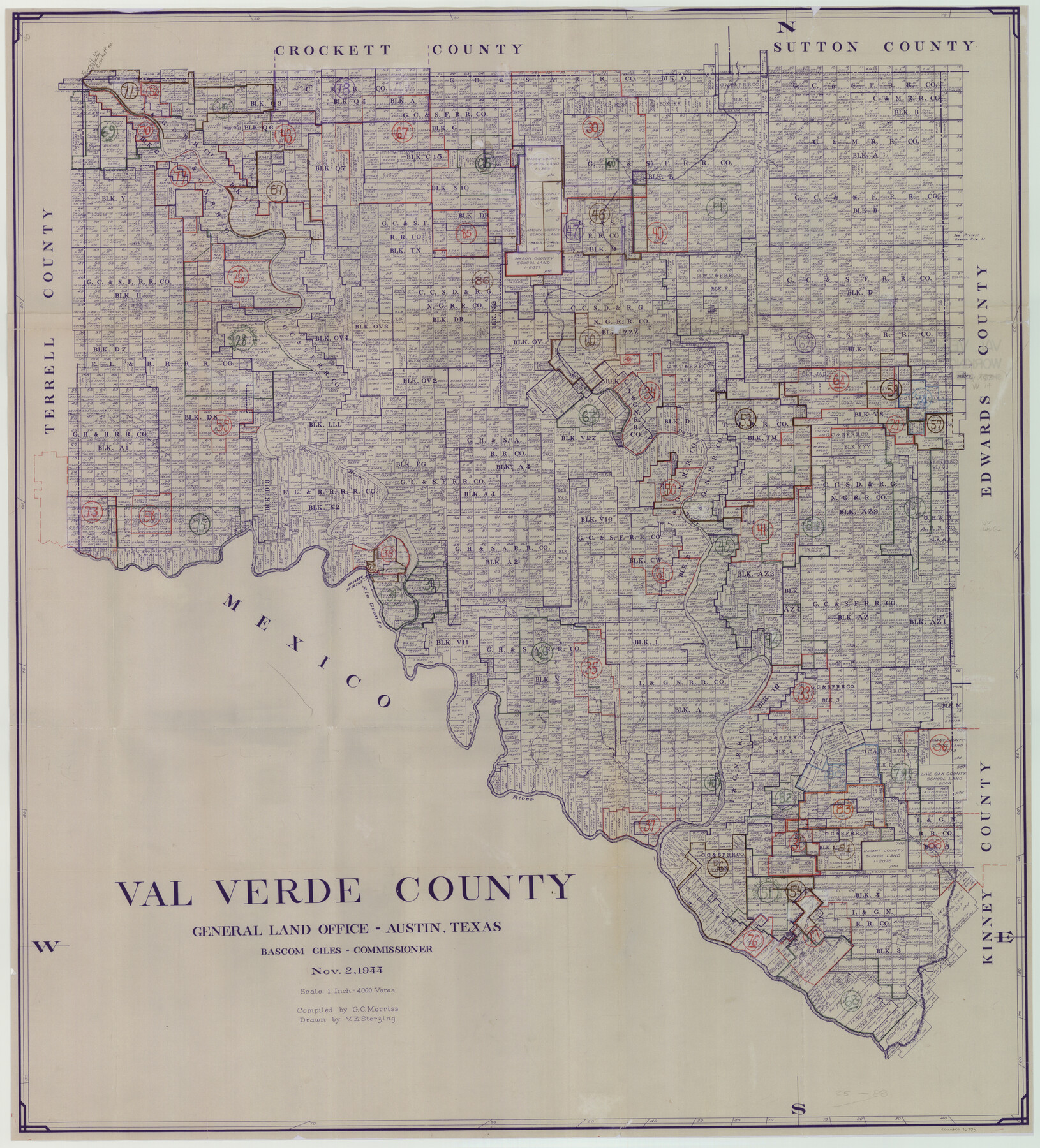
Val Verde County Working Sketch Graphic Index, Sheet 2 (Sketches 26 to 88)
-
Map/Doc
76725
-
Collection
General Map Collection
-
Object Dates
11/2/1944 (Creation Date)
-
People and Organizations
G.C. Morriss (Compiler)
Victor E. Sterzing (Draftsman)
-
Counties
Val Verde
-
Subjects
County Surveying Working Sketch
-
Height x Width
40.3 x 36.4 inches
102.4 x 92.5 cm
-
Scale
1" = 4000 varas
Part of: General Map Collection
Houston County Sketch File 2

Print $4.00
- Digital $50.00
Houston County Sketch File 2
1857
Size 12.6 x 7.9 inches
Map/Doc 26746
Upton County Working Sketch 15

Print $40.00
- Digital $50.00
Upton County Working Sketch 15
1940
Size 28.4 x 48.6 inches
Map/Doc 69511
Coke County Working Sketch 8

Print $20.00
- Digital $50.00
Coke County Working Sketch 8
1926
Size 26.9 x 25.5 inches
Map/Doc 68045
Nueces County Rolled Sketch 105

Print $96.00
Nueces County Rolled Sketch 105
1986
Size 18.1 x 25.4 inches
Map/Doc 7086
Jim Hogg County Sketch File 1

Print $20.00
- Digital $50.00
Jim Hogg County Sketch File 1
1931
Size 18.2 x 26.7 inches
Map/Doc 11883
Hall County Sketch File 33

Print $16.00
- Digital $50.00
Hall County Sketch File 33
1912
Size 11.4 x 8.7 inches
Map/Doc 24874
Controlled Mosaic by Jack Amman Photogrammetric Engineers, Inc - Sheet 52

Print $20.00
- Digital $50.00
Controlled Mosaic by Jack Amman Photogrammetric Engineers, Inc - Sheet 52
1954
Size 20.0 x 24.0 inches
Map/Doc 83511
[Surveys along the Pedernales River and Cypress Creek]
![121, [Surveys along the Pedernales River and Cypress Creek], General Map Collection](https://historictexasmaps.com/wmedia_w700/maps/121.tif.jpg)
Print $2.00
- Digital $50.00
[Surveys along the Pedernales River and Cypress Creek]
1841
Size 8.3 x 7.7 inches
Map/Doc 121
Wilson County Boundary File 2

Print $10.00
- Digital $50.00
Wilson County Boundary File 2
Size 12.3 x 8.3 inches
Map/Doc 60078
Starr County Sketch File 13

Print $20.00
- Digital $50.00
Starr County Sketch File 13
1886
Size 12.4 x 19.5 inches
Map/Doc 12329
Midland County Boundary File 4a

Print $40.00
- Digital $50.00
Midland County Boundary File 4a
Size 36.2 x 54.5 inches
Map/Doc 57185
Cherokee County Working Sketch 1

Print $20.00
- Digital $50.00
Cherokee County Working Sketch 1
1925
Size 22.9 x 24.1 inches
Map/Doc 67956
You may also like
Erath County Sketch File 7

Print $4.00
- Digital $50.00
Erath County Sketch File 7
Size 6.8 x 7.3 inches
Map/Doc 22267
Jeff Davis County Working Sketch 30

Print $20.00
- Digital $50.00
Jeff Davis County Working Sketch 30
1969
Size 36.1 x 31.2 inches
Map/Doc 66525
Map showing the line of the Cairo & Fulton Railroad and its connections.

Print $20.00
Map showing the line of the Cairo & Fulton Railroad and its connections.
1871
Size 24.0 x 22.0 inches
Map/Doc 93611

Crane County Working Sketch 12

Print $20.00
- Digital $50.00
Crane County Working Sketch 12
1941
Size 18.6 x 18.1 inches
Map/Doc 68289

J. De Cordova's Map of the State of Texas Compiled from the records of the General Land Office of the State

Print $20.00
- Digital $50.00
J. De Cordova's Map of the State of Texas Compiled from the records of the General Land Office of the State
1867
Size 38.0 x 35.4 inches
Map/Doc 93759
Town of Ropes Hockley County, Texas

Print $20.00
- Digital $50.00
Town of Ropes Hockley County, Texas
Size 29.5 x 29.8 inches
Map/Doc 92223
Fort Bend County Rolled Sketch 1

Print $20.00
- Digital $50.00
Fort Bend County Rolled Sketch 1
Size 24.3 x 27.5 inches
Map/Doc 5891
La Salle County Rolled Sketch 29

Print $20.00
- Digital $50.00
La Salle County Rolled Sketch 29
1984
Size 17.9 x 17.3 inches
Map/Doc 6589
Nueces County Aerial Photograph Index Sheet 5

Print $20.00
- Digital $50.00
Nueces County Aerial Photograph Index Sheet 5
1956
Size 19.5 x 23.4 inches
Map/Doc 83738
Plano del Presidio de Bahia dl Espiritus to dep te d' la Governacion de los Tejas

Plano del Presidio de Bahia dl Espiritus to dep te d' la Governacion de los Tejas
1766
Size 10.2 x 13.0 inches
Map/Doc 96516