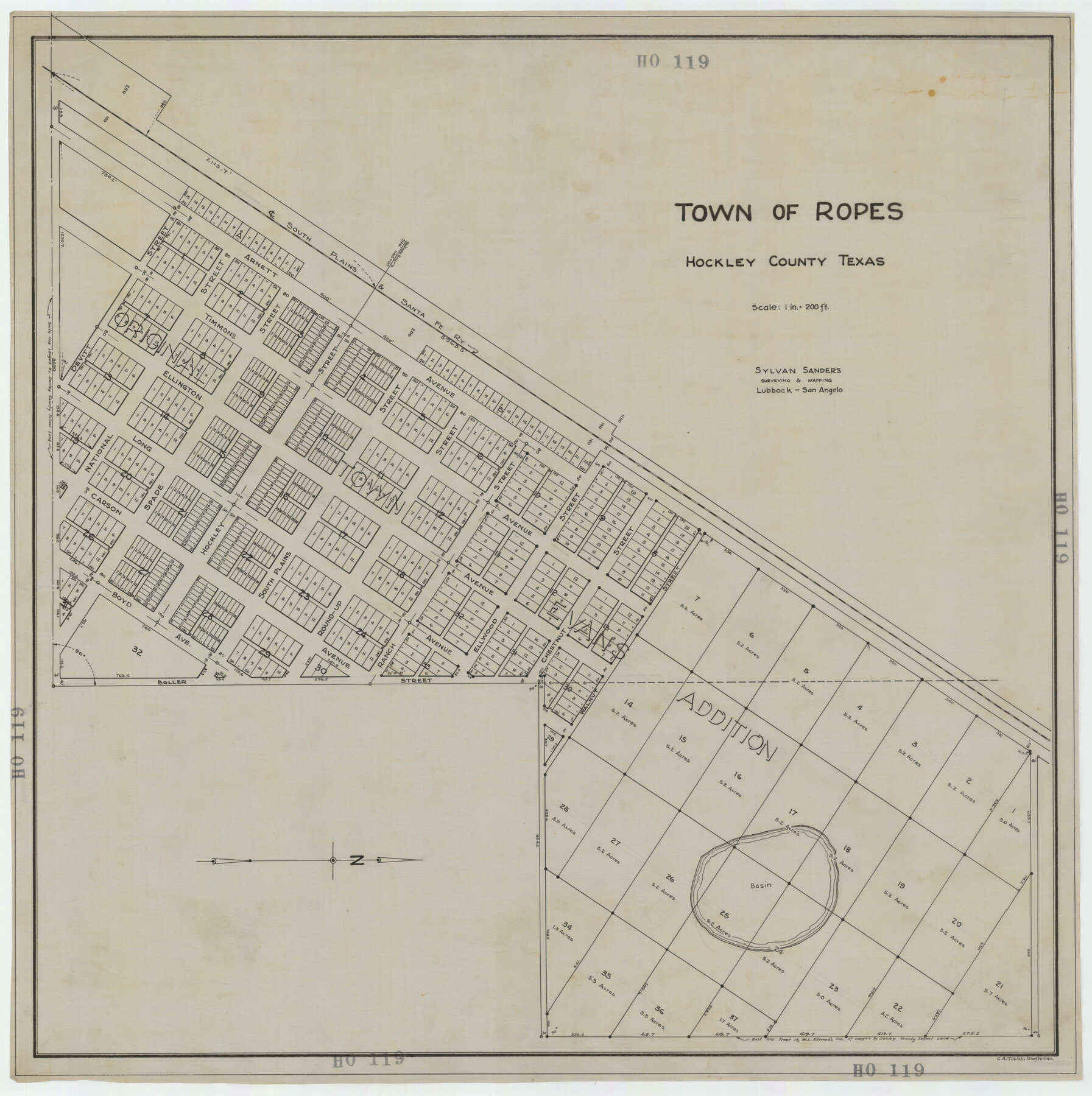
Town of Ropes Hockley County, Texas
HO119
-
Map/Doc
92223
-
Collection
Twichell Survey Records
-
People and Organizations
Sylvan Sanders (Surveyor/Engineer)
C.A. Tubbs (Draftsman)
-
Counties
Hockley
-
Height x Width
29.5 x 29.8 inches
74.9 x 75.7 cm
Part of: Twichell Survey Records
Miller-Stevens Subdivision Section 16, Block B

Print $20.00
- Digital $50.00
Miller-Stevens Subdivision Section 16, Block B
1944
Size 24.2 x 39.8 inches
Map/Doc 92401
MacKenzie SP - 52 - T Base Map

Print $20.00
- Digital $50.00
MacKenzie SP - 52 - T Base Map
1935
Size 36.9 x 24.9 inches
Map/Doc 92802
[3KA and vicinity]
![90846, [3KA and vicinity], Twichell Survey Records](https://historictexasmaps.com/wmedia_w700/maps/90846-2.tif.jpg)
Print $20.00
- Digital $50.00
[3KA and vicinity]
Size 32.9 x 10.3 inches
Map/Doc 90846
[North/South line through middle of Block K5]
![90600, [North/South line through middle of Block K5], Twichell Survey Records](https://historictexasmaps.com/wmedia_w700/maps/90600-1.tif.jpg)
Print $3.00
- Digital $50.00
[North/South line through middle of Block K5]
Size 6.8 x 16.9 inches
Map/Doc 90600
[Garza, Blanco, Uvalde and Crosby County School Land]
![90252, [Garza, Blanco, Uvalde and Crosby County School Land], Twichell Survey Records](https://historictexasmaps.com/wmedia_w700/maps/90252-1.tif.jpg)
Print $20.00
- Digital $50.00
[Garza, Blanco, Uvalde and Crosby County School Land]
1913
Size 12.4 x 12.2 inches
Map/Doc 90252
Bravo Ranch situated in Hartley and Oldham Counties, Texas

Print $40.00
- Digital $50.00
Bravo Ranch situated in Hartley and Oldham Counties, Texas
Size 38.8 x 51.3 inches
Map/Doc 89930
[Capitol Leagues 633, 634, 635, 636, and 637]
![90998, [Capitol Leagues 633, 634, 635, 636, and 637], Twichell Survey Records](https://historictexasmaps.com/wmedia_w700/maps/90998-1.tif.jpg)
Print $20.00
- Digital $50.00
[Capitol Leagues 633, 634, 635, 636, and 637]
Size 23.2 x 10.2 inches
Map/Doc 90998
Working Sketch in Kaufman County

Print $40.00
- Digital $50.00
Working Sketch in Kaufman County
1922
Size 36.5 x 52.2 inches
Map/Doc 89702
Green & Lumsden's Ranch

Print $20.00
- Digital $50.00
Green & Lumsden's Ranch
Size 28.4 x 24.7 inches
Map/Doc 92431
[Sketch showing surveys located in Block 6]
![91751, [Sketch showing surveys located in Block 6], Twichell Survey Records](https://historictexasmaps.com/wmedia_w700/maps/91751-1.tif.jpg)
Print $20.00
- Digital $50.00
[Sketch showing surveys located in Block 6]
Size 19.7 x 15.8 inches
Map/Doc 91751
[West half of Deaf Smith County showing School Land Leagues]
![90612, [West half of Deaf Smith County showing School Land Leagues], Twichell Survey Records](https://historictexasmaps.com/wmedia_w700/maps/90612-1.tif.jpg)
Print $20.00
- Digital $50.00
[West half of Deaf Smith County showing School Land Leagues]
Size 31.4 x 18.3 inches
Map/Doc 90612

You may also like
Galveston County Sketch File 16

Print $6.00
- Digital $50.00
Galveston County Sketch File 16
Size 7.8 x 6.3 inches
Map/Doc 23384
Eastland County Working Sketch 66

Print $20.00
- Digital $50.00
Eastland County Working Sketch 66
2014
Size 27.2 x 20.1 inches
Map/Doc 93708
Outer Continental Shelf Leasing Maps (Louisiana Offshore Operations)

Print $20.00
- Digital $50.00
Outer Continental Shelf Leasing Maps (Louisiana Offshore Operations)
1955
Size 23.3 x 15.5 inches
Map/Doc 76094
Bell County, Milam District

Print $20.00
- Digital $50.00
Bell County, Milam District
1877
Size 23.5 x 28.6 inches
Map/Doc 3293
Map of Northern Boundary Line of Texas and Pacific 80 Mile Reservation

Print $20.00
- Digital $50.00
Map of Northern Boundary Line of Texas and Pacific 80 Mile Reservation
1902
Size 16.8 x 16.7 inches
Map/Doc 65694
The United States of America

Print $20.00
- Digital $50.00
The United States of America
1866
Size 21.3 x 18.3 inches
Map/Doc 72646
Brewster County Sketch File 15

Print $120.00
- Digital $50.00
Brewster County Sketch File 15
1935
Size 14.2 x 8.8 inches
Map/Doc 15758
Cottle County Sketch File A and B

Print $27.00
- Digital $50.00
Cottle County Sketch File A and B
Size 18.4 x 24.1 inches
Map/Doc 11200
Rio Grande, Harlingen Sheet

Print $20.00
- Digital $50.00
Rio Grande, Harlingen Sheet
1935
Size 37.2 x 37.2 inches
Map/Doc 65113
San Jacinto County Sketch File 16

Print $4.00
San Jacinto County Sketch File 16
1934
Size 11.3 x 8.7 inches
Map/Doc 35729
Hays County Working Sketch 19

Print $20.00
- Digital $50.00
Hays County Working Sketch 19
1980
Size 30.1 x 26.0 inches
Map/Doc 66093
Red River County Sketch File 18

Print $2.00
- Digital $50.00
Red River County Sketch File 18
Size 5.5 x 7.9 inches
Map/Doc 35149