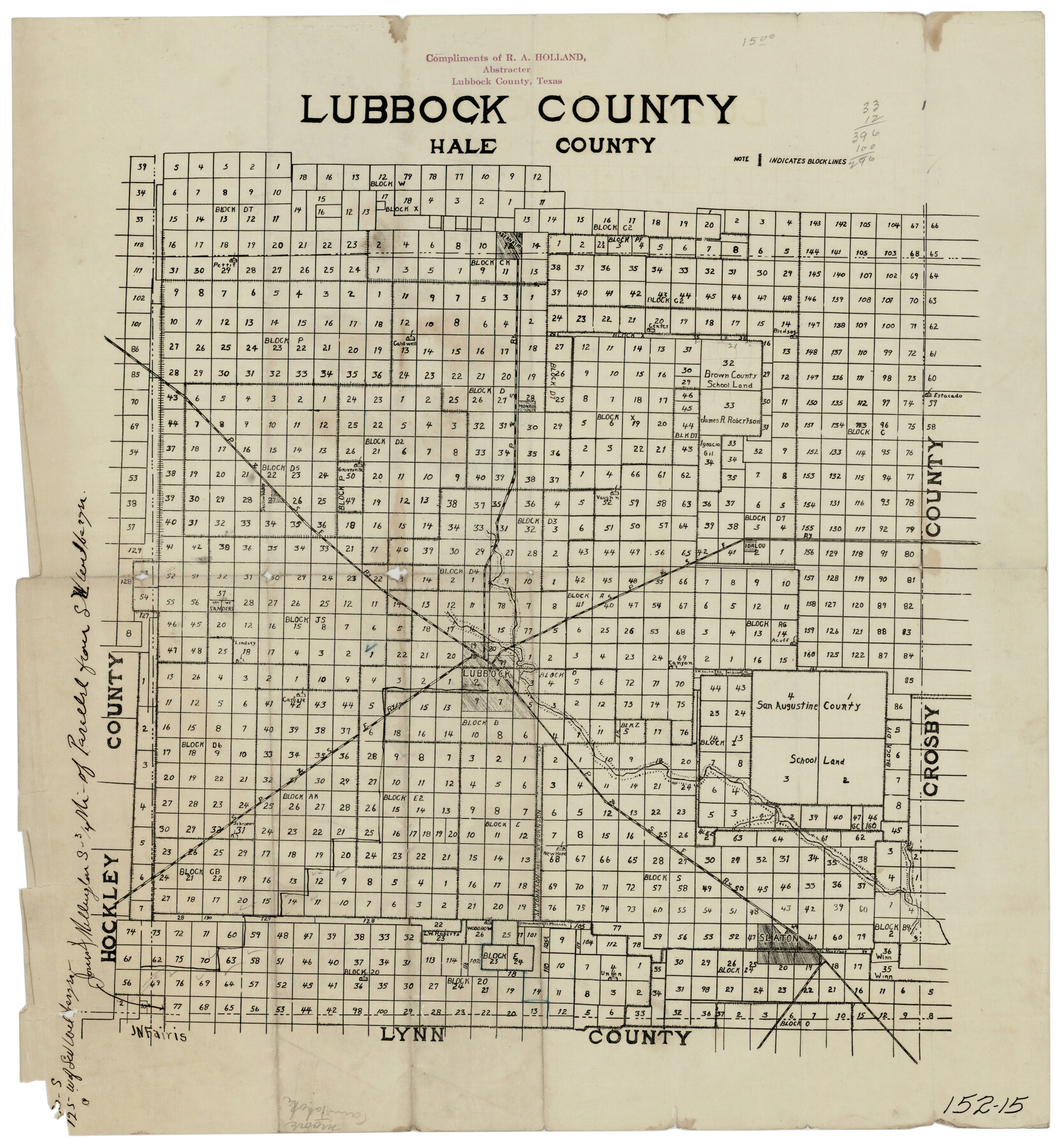
Lubbock County
152-15
-
Map/Doc
93020
-
Collection
Twichell Survey Records
-
Counties
Lubbock
-
Subjects
County
-
Height x Width
13.2 x 14.2 inches
33.5 x 36.1 cm
Part of: Twichell Survey Records
Crosby County Lands with Topographical Features

Print $2.00
- Digital $50.00
Crosby County Lands with Topographical Features
Size 8.7 x 11.2 inches
Map/Doc 90369
[River Meander along Jas. Tobin Survey and others]
![89814, [River Meander along Jas. Tobin Survey and others], Twichell Survey Records](https://historictexasmaps.com/wmedia_w700/maps/89814-1.tif.jpg)
Print $40.00
- Digital $50.00
[River Meander along Jas. Tobin Survey and others]
Size 73.6 x 43.9 inches
Map/Doc 89814
[Capitol Leagues in Northwest Lamb and Northeast Bailey Counties]
![91071, [Capitol Leagues in Northwest Lamb and Northeast Bailey Counties], Twichell Survey Records](https://historictexasmaps.com/wmedia_w700/maps/91071-1.tif.jpg)
Print $20.00
- Digital $50.00
[Capitol Leagues in Northwest Lamb and Northeast Bailey Counties]
Size 28.1 x 19.7 inches
Map/Doc 91071
Map of North Alamosa Pasture

Print $20.00
- Digital $50.00
Map of North Alamosa Pasture
Size 17.7 x 15.7 inches
Map/Doc 91431
Sketch of Lands in Oldham County, Texas

Print $2.00
- Digital $50.00
Sketch of Lands in Oldham County, Texas
Size 8.1 x 9.4 inches
Map/Doc 91441
Platte (sic) of the unorganized County School Lands in the District of Young

Print $20.00
- Digital $50.00
Platte (sic) of the unorganized County School Lands in the District of Young
Size 16.0 x 12.3 inches
Map/Doc 90447
[Part of Block 3, Leagues 83, 84, 95, 96, 104, 105, 116-113, 127-132, 140-142]
![90572, [Part of Block 3, Leagues 83, 84, 95, 96, 104, 105, 116-113, 127-132, 140-142], Twichell Survey Records](https://historictexasmaps.com/wmedia_w700/maps/90572-1.tif.jpg)
Print $20.00
- Digital $50.00
[Part of Block 3, Leagues 83, 84, 95, 96, 104, 105, 116-113, 127-132, 140-142]
Size 25.9 x 31.6 inches
Map/Doc 90572
[Report showing connections and corners made on ground in south part of Yoakum County and north part of Gaines County, Texas]

[Report showing connections and corners made on ground in south part of Yoakum County and north part of Gaines County, Texas]
1938
Size 8.1 x 10.9 inches
Map/Doc 93256
[State Capitol Leagues and County School Leagues]
![92475, [State Capitol Leagues and County School Leagues], Twichell Survey Records](https://historictexasmaps.com/wmedia_w700/maps/92475-1.tif.jpg)
Print $20.00
- Digital $50.00
[State Capitol Leagues and County School Leagues]
Size 19.4 x 11.8 inches
Map/Doc 92475
[PSL Blocks A6-A12]
![89780, [PSL Blocks A6-A12], Twichell Survey Records](https://historictexasmaps.com/wmedia_w700/maps/89780-1.tif.jpg)
Print $40.00
- Digital $50.00
[PSL Blocks A6-A12]
Size 23.2 x 64.7 inches
Map/Doc 89780
J. F. Kelley Farm

Print $20.00
- Digital $50.00
J. F. Kelley Farm
Size 16.3 x 19.5 inches
Map/Doc 92408
Desdemona Oil Pool

Print $20.00
- Digital $50.00
Desdemona Oil Pool
Size 38.7 x 43.1 inches
Map/Doc 89773
You may also like
Flight Mission No. CLL-1N, Frame 185, Willacy County

Print $20.00
- Digital $50.00
Flight Mission No. CLL-1N, Frame 185, Willacy County
1954
Size 18.4 x 22.1 inches
Map/Doc 87055
Harris County Working Sketch 19

Print $40.00
- Digital $50.00
Harris County Working Sketch 19
1921
Size 42.5 x 55.0 inches
Map/Doc 65911
Crane County Working Sketch 21

Print $20.00
- Digital $50.00
Crane County Working Sketch 21
1961
Size 34.5 x 37.1 inches
Map/Doc 68298
United States Great Lakes and adjacent waterways

Print $20.00
- Digital $50.00
United States Great Lakes and adjacent waterways
Size 20.8 x 42.7 inches
Map/Doc 76122
Howard County Rolled Sketch 4

Print $20.00
- Digital $50.00
Howard County Rolled Sketch 4
1909
Size 35.6 x 27.4 inches
Map/Doc 6233
Brewster County Rolled Sketch 67

Print $20.00
- Digital $50.00
Brewster County Rolled Sketch 67
1940
Size 32.0 x 23.5 inches
Map/Doc 5233
Young County Working Sketch 19

Print $20.00
- Digital $50.00
Young County Working Sketch 19
1961
Size 27.2 x 23.7 inches
Map/Doc 62042
[Leagues 656-666, 671-676, 684-688, 692-695]
![91007, [Leagues 656-666, 671-676, 684-688, 692-695], Twichell Survey Records](https://historictexasmaps.com/wmedia_w700/maps/91007-1.tif.jpg)
Print $20.00
- Digital $50.00
[Leagues 656-666, 671-676, 684-688, 692-695]
Size 30.6 x 20.7 inches
Map/Doc 91007
Map of Marion County

Print $20.00
- Digital $50.00
Map of Marion County
1920
Size 29.6 x 42.7 inches
Map/Doc 66917
Pecos County Sketch File 103

Print $46.00
- Digital $50.00
Pecos County Sketch File 103
1963
Size 16.7 x 9.9 inches
Map/Doc 34016
Dimmit County Sketch File 42

Print $2.00
- Digital $50.00
Dimmit County Sketch File 42
1901
Size 6.2 x 3.9 inches
Map/Doc 21171
Kaufman County Sketch File A

Print $4.00
- Digital $50.00
Kaufman County Sketch File A
1879
Size 14.1 x 8.8 inches
Map/Doc 28630