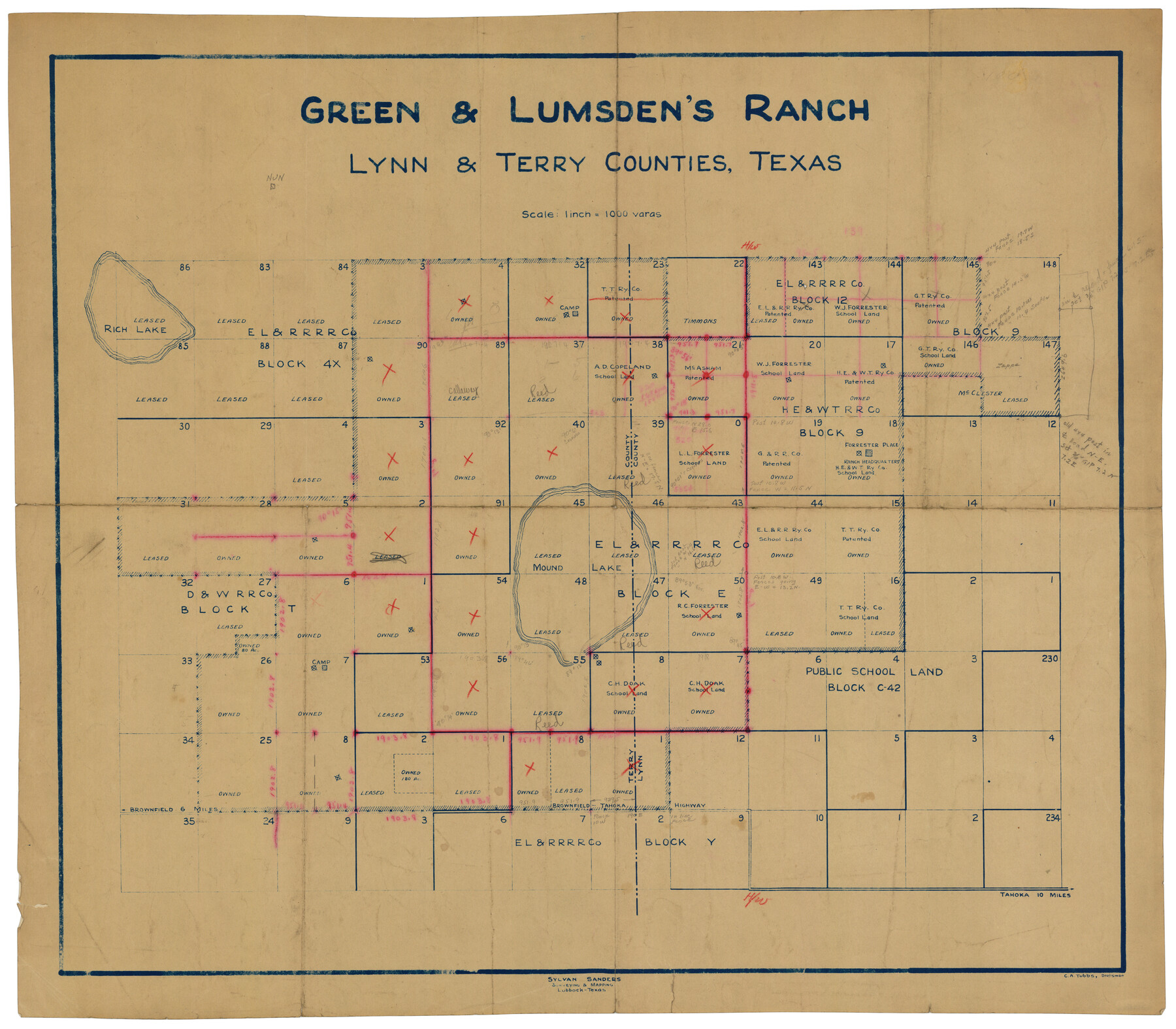
Green & Lumsden's Ranch
-
Map/Doc
92431
-
Collection
Twichell Survey Records
-
People and Organizations
Sylvan Sanders (Surveyor/Engineer)
C.A. Tubbs (Draftsman)
-
Counties
Terry Lynn
-
Height x Width
28.4 x 24.7 inches
72.1 x 62.7 cm
Part of: Twichell Survey Records
Robertson V Ranch

Print $20.00
- Digital $50.00
Robertson V Ranch
Size 41.7 x 46.0 inches
Map/Doc 89756
Myrick Farm Lubbock & Hockley Counties

Print $20.00
- Digital $50.00
Myrick Farm Lubbock & Hockley Counties
Size 21.1 x 18.8 inches
Map/Doc 92831
[PSL Blocks A57, 77; B1-B3, T. & P. Block 46, T-1-N]
![90167, [PSL Blocks A57, 77; B1-B3, T. & P. Block 46, T-1-N], Twichell Survey Records](https://historictexasmaps.com/wmedia_w700/maps/90167-1.tif.jpg)
Print $20.00
- Digital $50.00
[PSL Blocks A57, 77; B1-B3, T. & P. Block 46, T-1-N]
Size 33.4 x 36.1 inches
Map/Doc 90167
Ellwood Farms Situated in Hockley, Lamb, and Hale Counties, Texas

Print $20.00
- Digital $50.00
Ellwood Farms Situated in Hockley, Lamb, and Hale Counties, Texas
Size 21.5 x 32.7 inches
Map/Doc 92227
[T. T. RR. Co. Block 8 and vicinity]
![90875, [T. T. RR. Co. Block 8 and vicinity], Twichell Survey Records](https://historictexasmaps.com/wmedia_w700/maps/90875-2.tif.jpg)
Print $20.00
- Digital $50.00
[T. T. RR. Co. Block 8 and vicinity]
Size 25.3 x 39.0 inches
Map/Doc 90875
[Blocks 16, O, N, B19 and 34]
![91958, [Blocks 16, O, N, B19 and 34], Twichell Survey Records](https://historictexasmaps.com/wmedia_w700/maps/91958-1.tif.jpg)
Print $20.00
- Digital $50.00
[Blocks 16, O, N, B19 and 34]
Size 22.5 x 26.1 inches
Map/Doc 91958
[Gunter & Munson, Maddox Bros. & Anderson Block O]
![91946, [Gunter & Munson, Maddox Bros. & Anderson Block O], Twichell Survey Records](https://historictexasmaps.com/wmedia_w700/maps/91946-1.tif.jpg)
Print $20.00
- Digital $50.00
[Gunter & Munson, Maddox Bros. & Anderson Block O]
Size 25.8 x 40.6 inches
Map/Doc 91946
[PSL Blks. A55, A56, 77, B1, B2, B6 and and B10]
![89821, [PSL Blks. A55, A56, 77, B1, B2, B6 and and B10], Twichell Survey Records](https://historictexasmaps.com/wmedia_w700/maps/89821-1.tif.jpg)
Print $40.00
- Digital $50.00
[PSL Blks. A55, A56, 77, B1, B2, B6 and and B10]
Size 24.0 x 69.3 inches
Map/Doc 89821
Map Showing Division Line Between Chapman and Mills' Lands

Print $20.00
- Digital $50.00
Map Showing Division Line Between Chapman and Mills' Lands
Size 32.5 x 31.6 inches
Map/Doc 92848
Brazos River Conservation and Reclamation District Official Boundary Line Survey

Print $20.00
- Digital $50.00
Brazos River Conservation and Reclamation District Official Boundary Line Survey
Size 25.0 x 37.0 inches
Map/Doc 90182
[Surveys in the vicinity of Archibald Smith's Survey and the Cyrena McReara Survey]
![92118, [Surveys in the vicinity of Archibald Smith's Survey and the Cyrena McReara Survey], Twichell Survey Records](https://historictexasmaps.com/wmedia_w700/maps/92118-1.tif.jpg)
Print $20.00
- Digital $50.00
[Surveys in the vicinity of Archibald Smith's Survey and the Cyrena McReara Survey]
Size 27.8 x 32.5 inches
Map/Doc 92118
[Surveys South of Levi Pruitt]
![92092, [Surveys South of Levi Pruitt], Twichell Survey Records](https://historictexasmaps.com/wmedia_w700/maps/92092-1.tif.jpg)
Print $3.00
- Digital $50.00
[Surveys South of Levi Pruitt]
1924
Size 11.3 x 11.6 inches
Map/Doc 92092
You may also like
Flight Mission No. CUG-1P, Frame 82, Kleberg County

Print $20.00
- Digital $50.00
Flight Mission No. CUG-1P, Frame 82, Kleberg County
1956
Size 18.6 x 22.3 inches
Map/Doc 86147
Flight Mission No. BQR-13K, Frame 25, Brazoria County

Print $20.00
- Digital $50.00
Flight Mission No. BQR-13K, Frame 25, Brazoria County
1952
Size 18.8 x 22.4 inches
Map/Doc 84073
Colorado County Working Sketch 20

Print $20.00
- Digital $50.00
Colorado County Working Sketch 20
1963
Size 27.9 x 24.7 inches
Map/Doc 68120
Edwards County Sketch File 2 and 3

Print $8.00
- Digital $50.00
Edwards County Sketch File 2 and 3
1874
Size 9.3 x 4.1 inches
Map/Doc 21676
Irion County Rolled Sketch 8

Print $20.00
- Digital $50.00
Irion County Rolled Sketch 8
Size 42.9 x 34.1 inches
Map/Doc 9251
Jeff Davis County Sketch File 32

Print $20.00
- Digital $50.00
Jeff Davis County Sketch File 32
Size 23.8 x 18.8 inches
Map/Doc 11865
Hays County Rolled Sketch 20A

Print $20.00
- Digital $50.00
Hays County Rolled Sketch 20A
Size 20.7 x 23.9 inches
Map/Doc 6177
Reeves County Rolled Sketch N1

Print $20.00
- Digital $50.00
Reeves County Rolled Sketch N1
Size 21.8 x 41.9 inches
Map/Doc 7505
Liberty County Rolled Sketch B

Print $20.00
- Digital $50.00
Liberty County Rolled Sketch B
Size 34.9 x 28.2 inches
Map/Doc 9570
Kerr County Working Sketch 11

Print $20.00
- Digital $50.00
Kerr County Working Sketch 11
1951
Size 30.3 x 29.9 inches
Map/Doc 70042
Young County Rolled Sketch 7

Print $20.00
- Digital $50.00
Young County Rolled Sketch 7
Size 37.3 x 26.4 inches
Map/Doc 8295
Briscoe County Sketch File 5

Print $40.00
- Digital $50.00
Briscoe County Sketch File 5
Size 29.8 x 26.5 inches
Map/Doc 10994