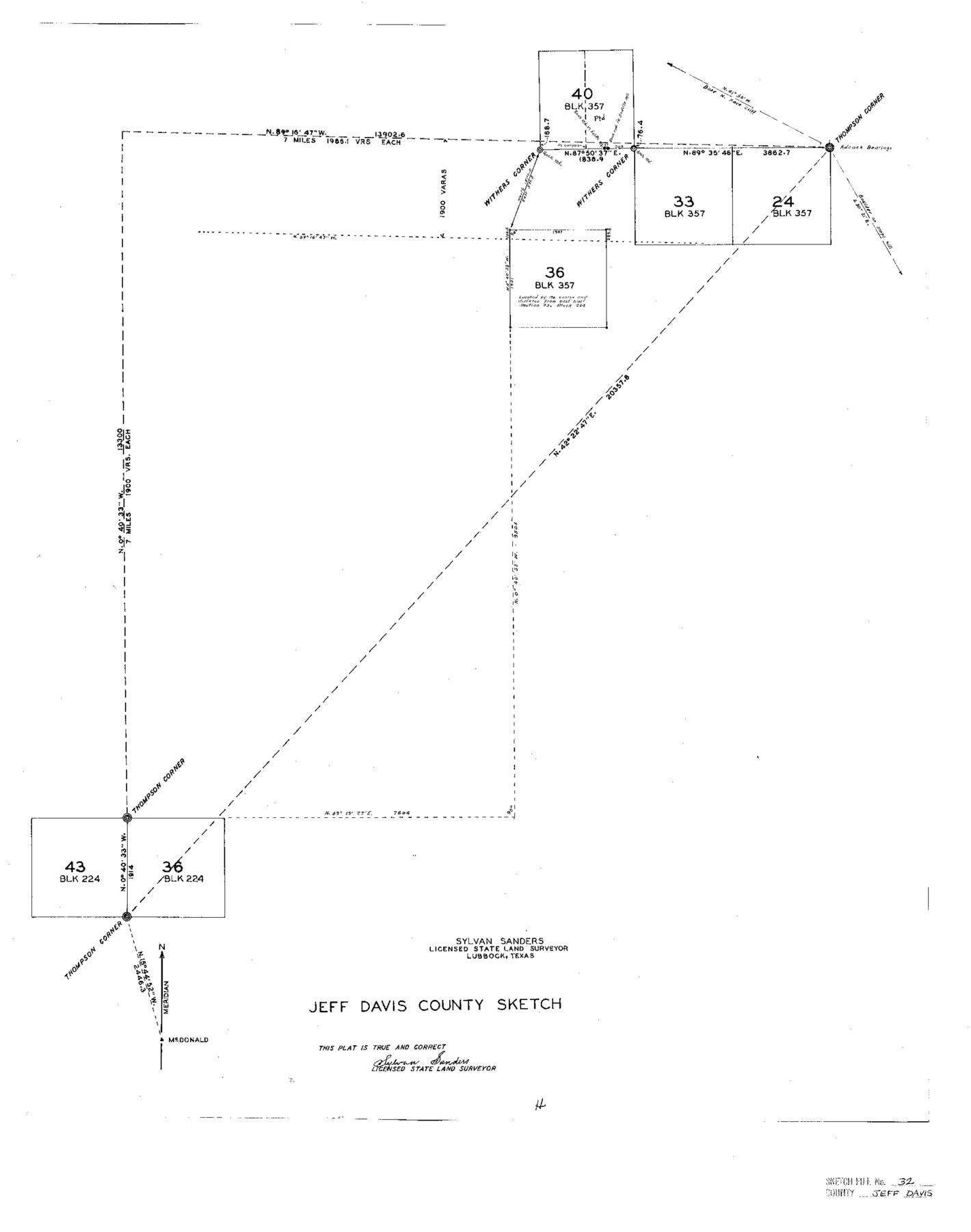
Jeff Davis County Sketch File 32
Connecting line Block 357 Block 311 and Block 224
-
Map/Doc
11865
-
Collection
General Map Collection
-
Object Dates
3/10/1944 (File Date)
-
People and Organizations
Sylvan Sanders (Surveyor/Engineer)
-
Counties
Jeff Davis
-
Subjects
Surveying Sketch File
-
Height x Width
23.8 x 18.8 inches
60.5 x 47.8 cm
-
Medium
paper, print
Part of: General Map Collection
Aransas County Sketch File 22

Print $34.00
- Digital $50.00
Aransas County Sketch File 22
1910
Size 14.8 x 9.1 inches
Map/Doc 13166
Val Verde County Boundary File 103a

Print $8.00
- Digital $50.00
Val Verde County Boundary File 103a
Size 14.4 x 8.8 inches
Map/Doc 59600
Coleman County Sketch File 35

Print $2.00
- Digital $50.00
Coleman County Sketch File 35
Size 8.4 x 8.2 inches
Map/Doc 18740
King County Sketch File 11

Print $40.00
- Digital $50.00
King County Sketch File 11
1902
Size 13.7 x 9.1 inches
Map/Doc 29085
Midland County Sketch File 18

Print $4.00
- Digital $50.00
Midland County Sketch File 18
Size 14.7 x 8.1 inches
Map/Doc 31585
Trinity County Sketch File 38

Print $8.00
- Digital $50.00
Trinity County Sketch File 38
1948
Size 14.5 x 8.9 inches
Map/Doc 38593
Van Zandt County Sketch File 22

Print $6.00
- Digital $50.00
Van Zandt County Sketch File 22
Size 8.6 x 7.8 inches
Map/Doc 39432
Cottle County Working Sketch 12

Print $20.00
- Digital $50.00
Cottle County Working Sketch 12
1959
Size 39.1 x 25.7 inches
Map/Doc 68322
Flight Mission No. DQO-3K, Frame 16, Galveston County

Print $20.00
- Digital $50.00
Flight Mission No. DQO-3K, Frame 16, Galveston County
1952
Size 18.9 x 22.5 inches
Map/Doc 85057
Map of Hamilton County

Print $20.00
- Digital $50.00
Map of Hamilton County
1916
Size 38.3 x 40.9 inches
Map/Doc 4695
Edwards County Working Sketch 20

Print $20.00
- Digital $50.00
Edwards County Working Sketch 20
1935
Size 43.2 x 42.6 inches
Map/Doc 68896
Val Verde County Working Sketch 40

Print $20.00
- Digital $50.00
Val Verde County Working Sketch 40
1943
Size 31.5 x 29.8 inches
Map/Doc 72175
You may also like
Gray County Sketch File 13

Print $20.00
- Digital $50.00
Gray County Sketch File 13
1946
Size 16.7 x 15.9 inches
Map/Doc 11578
Parker County Sketch File 32

Print $6.00
- Digital $50.00
Parker County Sketch File 32
Size 11.0 x 12.2 inches
Map/Doc 33574
United States Gulf Coast - from Galveston to the Rio Grande

Print $20.00
- Digital $50.00
United States Gulf Coast - from Galveston to the Rio Grande
1915
Size 26.3 x 18.3 inches
Map/Doc 72731
Red River County Sketch File 4

Print $6.00
- Digital $50.00
Red River County Sketch File 4
Size 9.3 x 11.5 inches
Map/Doc 35100
Presidio County Rolled Sketch 131A

Print $40.00
- Digital $50.00
Presidio County Rolled Sketch 131A
1991
Size 37.6 x 49.7 inches
Map/Doc 10713
Pecos County Rolled Sketch 46

Print $3.00
- Digital $50.00
Pecos County Rolled Sketch 46
1913
Size 13.4 x 9.7 inches
Map/Doc 7224
Cass County Working Sketch 9

Print $20.00
- Digital $50.00
Cass County Working Sketch 9
1937
Size 28.4 x 32.7 inches
Map/Doc 67912
Newton County Working Sketch 25

Print $20.00
- Digital $50.00
Newton County Working Sketch 25
1953
Size 25.4 x 23.8 inches
Map/Doc 71271
Amplissimae Regionis Mississipi seu Provinciae Ludovicianae a R.P. Ludovico Hennepin Francisc Miss in America Septentrionali Anno 1687. Detectae, Nunc Gallorum Coloniis et Actionum Negotiis Toto Orbe Celeberrimae

Print $20.00
- Digital $50.00
Amplissimae Regionis Mississipi seu Provinciae Ludovicianae a R.P. Ludovico Hennepin Francisc Miss in America Septentrionali Anno 1687. Detectae, Nunc Gallorum Coloniis et Actionum Negotiis Toto Orbe Celeberrimae
1720
Size 20.7 x 24.2 inches
Map/Doc 97516
Current Miscellaneous File 73

Print $8.00
- Digital $50.00
Current Miscellaneous File 73
1959
Size 11.4 x 8.7 inches
Map/Doc 74177
Cochran County Sketch [showing lines run by C. A. Tubbs]
![90443, Cochran County Sketch [showing lines run by C. A. Tubbs], Twichell Survey Records](https://historictexasmaps.com/wmedia_w700/maps/90443-1.tif.jpg)
Print $20.00
- Digital $50.00
Cochran County Sketch [showing lines run by C. A. Tubbs]
Size 9.6 x 23.5 inches
Map/Doc 90443
Sketch showing connections made in survey of the Jerry Barton preemption

Print $20.00
- Digital $50.00
Sketch showing connections made in survey of the Jerry Barton preemption
1892
Size 18.5 x 23.6 inches
Map/Doc 75558