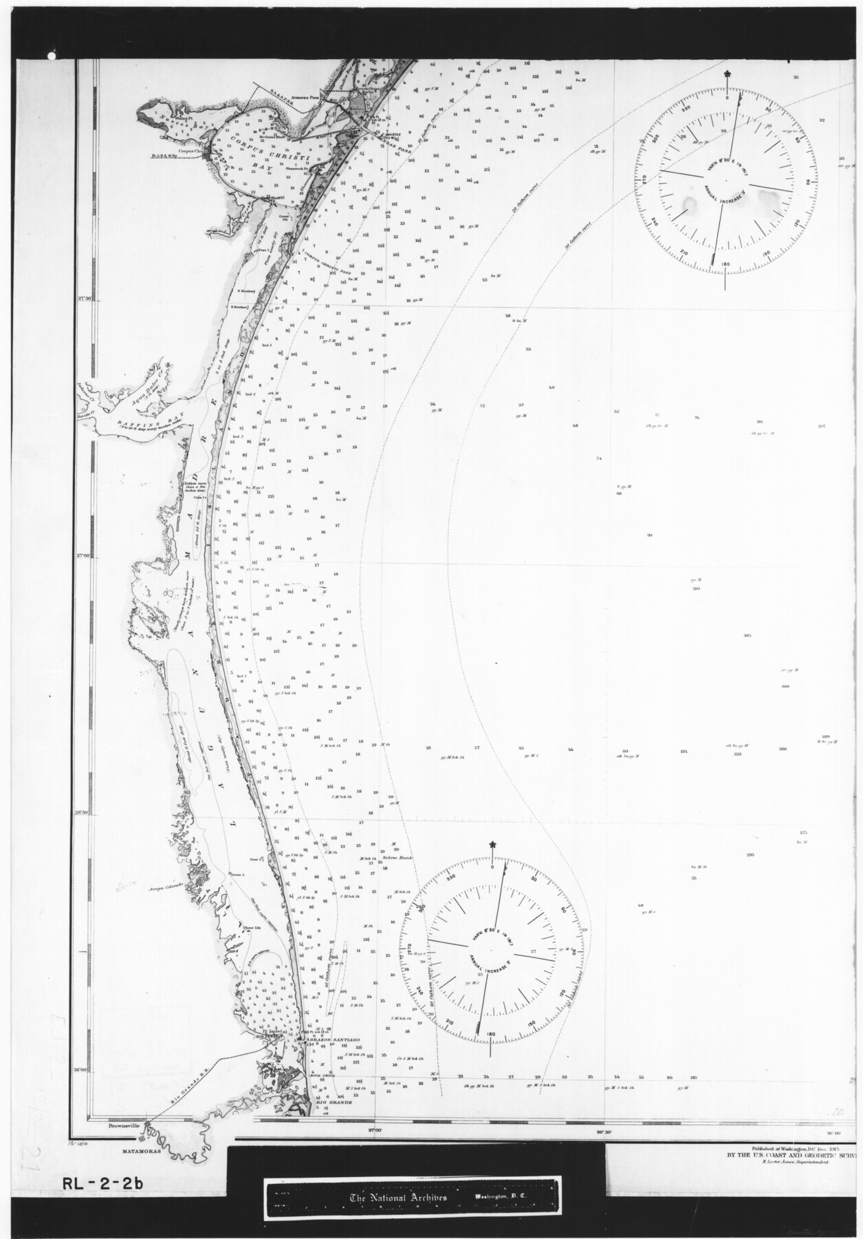
United States Gulf Coast - from Galveston to the Rio Grande
RL-2-2b
-
Map/Doc
72731
-
Collection
General Map Collection
-
Object Dates
1915 (Creation Date)
-
People and Organizations
U. S. Coast and Geodetic Survey (Publisher)
-
Subjects
Nautical Charts
-
Height x Width
26.3 x 18.3 inches
66.8 x 46.5 cm
-
Comments
B/W photostat copy from National Archives in multiple pieces.
Part of: General Map Collection
Edwards County Working Sketch 8

Print $20.00
- Digital $50.00
Edwards County Working Sketch 8
1918
Size 19.2 x 31.2 inches
Map/Doc 68884
Briscoe County Rolled Sketch 9

Print $20.00
- Digital $50.00
Briscoe County Rolled Sketch 9
Size 30.6 x 21.4 inches
Map/Doc 5327
[Overlay for Fractional Township No. 7 South Range No. 17 East of the Indian Meridian, Indian Territory]
![75230, [Overlay for Fractional Township No. 7 South Range No. 17 East of the Indian Meridian, Indian Territory], General Map Collection](https://historictexasmaps.com/wmedia_w700/maps/75230.tif.jpg)
Print $3.00
- Digital $50.00
[Overlay for Fractional Township No. 7 South Range No. 17 East of the Indian Meridian, Indian Territory]
Size 11.2 x 11.7 inches
Map/Doc 75230
Map of Europe to illustrate Olney's school geography (Inset: Central Europe)

Print $20.00
- Digital $50.00
Map of Europe to illustrate Olney's school geography (Inset: Central Europe)
1844
Size 12.1 x 19.0 inches
Map/Doc 93546
San Augustine Co.

Print $20.00
- Digital $50.00
San Augustine Co.
1949
Size 47.9 x 31.2 inches
Map/Doc 73281
Crockett County Sketch File 49 and 50

Print $14.00
- Digital $50.00
Crockett County Sketch File 49 and 50
Size 14.3 x 8.8 inches
Map/Doc 19792

Map of Kinney County

Print $40.00
- Digital $50.00
Map of Kinney County
1889
Size 50.1 x 41.1 inches
Map/Doc 16869
Sterling County Working Sketch 5

Print $20.00
- Digital $50.00
Sterling County Working Sketch 5
1954
Size 18.9 x 34.9 inches
Map/Doc 63987
Foard County Sketch File 36

Print $20.00
- Digital $50.00
Foard County Sketch File 36
Size 15.4 x 28.0 inches
Map/Doc 11498
Runnels County Sketch File 19 and 22

Print $48.00
Runnels County Sketch File 19 and 22
1887
Size 14.0 x 21.2 inches
Map/Doc 12254
Wise County Sketch File 24

Print $4.00
- Digital $50.00
Wise County Sketch File 24
1860
Size 12.3 x 7.8 inches
Map/Doc 40570
You may also like
Coryell County, Texas

Print $20.00
- Digital $50.00
Coryell County, Texas
1879
Size 23.5 x 29.1 inches
Map/Doc 704
Flight Mission No. CLL-4N, Frame 39, Willacy County

Print $20.00
- Digital $50.00
Flight Mission No. CLL-4N, Frame 39, Willacy County
1954
Size 18.3 x 22.0 inches
Map/Doc 87112
Maps & Lists Showing Prison Lands (Oil & Gas) Leased as of June 1955

Digital $50.00
Maps & Lists Showing Prison Lands (Oil & Gas) Leased as of June 1955
1930
Size 24.4 x 26.8 inches
Map/Doc 62876
Upton County Working Sketch 22

Print $40.00
- Digital $50.00
Upton County Working Sketch 22
1951
Size 37.5 x 48.7 inches
Map/Doc 69518
Bosque County Sketch File 3

Print $40.00
- Digital $50.00
Bosque County Sketch File 3
1848
Size 16.1 x 12.4 inches
Map/Doc 14742

Kerr County Rolled Sketch 14

Print $20.00
- Digital $50.00
Kerr County Rolled Sketch 14
1951
Size 38.3 x 30.6 inches
Map/Doc 9345
[Sketch of "B" Blocks]
![89749, [Sketch of "B" Blocks], Twichell Survey Records](https://historictexasmaps.com/wmedia_w700/maps/89749-1.tif.jpg)
Print $40.00
- Digital $50.00
[Sketch of "B" Blocks]
Size 61.7 x 38.1 inches
Map/Doc 89749
Refugio County Sketch File 8a

Print $2.00
- Digital $50.00
Refugio County Sketch File 8a
Size 8.1 x 10.2 inches
Map/Doc 35253
Gulf Intracoastal Waterway - Aransas Bay to Corpus Christi Bay - Modified Route Main Channel

Print $20.00
- Digital $50.00
Gulf Intracoastal Waterway - Aransas Bay to Corpus Christi Bay - Modified Route Main Channel
1960
Size 31.0 x 42.7 inches
Map/Doc 61901
Irion County Boundary File 1a

Print $40.00
- Digital $50.00
Irion County Boundary File 1a
Size 33.5 x 9.3 inches
Map/Doc 55325
Comanche County Working Sketch 9

Print $20.00
- Digital $50.00
Comanche County Working Sketch 9
1954
Size 18.6 x 21.5 inches
Map/Doc 68143