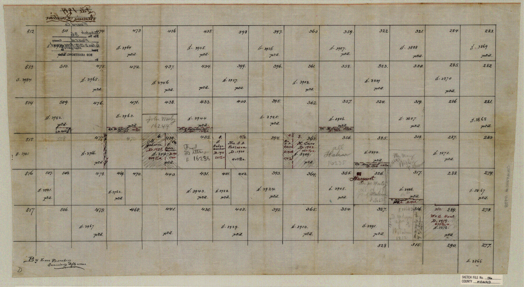
Foard County Sketch File 36
[From Fan. D-1919 - Area around Margaret]
-
Map/Doc
11498
-
Collection
General Map Collection
-
People and Organizations
E. von Rosenberg (Draftsman)
-
Counties
Foard Hardeman
-
Subjects
Surveying Sketch File
-
Height x Width
15.4 x 28.0 inches
39.1 x 71.1 cm
-
Medium
paper, manuscript
-
Features
Margaret
Part of: General Map Collection
Hockley County Rolled Sketch 5

Print $40.00
- Digital $50.00
Hockley County Rolled Sketch 5
Size 80.8 x 29.5 inches
Map/Doc 9175
Houston County

Print $40.00
- Digital $50.00
Houston County
1944
Size 52.4 x 52.2 inches
Map/Doc 95534
Aransas County Rolled Sketch 31A

Print $20.00
- Digital $50.00
Aransas County Rolled Sketch 31A
1950
Size 25.1 x 42.4 inches
Map/Doc 77499
Dawson County

Print $20.00
- Digital $50.00
Dawson County
1959
Size 43.5 x 35.1 inches
Map/Doc 77259
Kent County Sketch File 15

Print $8.00
- Digital $50.00
Kent County Sketch File 15
1936
Size 11.4 x 7.2 inches
Map/Doc 28842
Map of Burleson County

Print $20.00
- Digital $50.00
Map of Burleson County
1856
Size 22.0 x 31.5 inches
Map/Doc 3345
Maverick County Working Sketch 9

Print $20.00
- Digital $50.00
Maverick County Working Sketch 9
1959
Size 43.8 x 42.2 inches
Map/Doc 70901
Reagan County Rolled Sketch 17A

Print $20.00
- Digital $50.00
Reagan County Rolled Sketch 17A
1948
Size 33.8 x 32.4 inches
Map/Doc 9813
Dawson County Sketch File A1

Print $20.00
- Digital $50.00
Dawson County Sketch File A1
1923
Size 14.8 x 33.4 inches
Map/Doc 11299
Briscoe County Working Sketch 6

Print $20.00
- Digital $50.00
Briscoe County Working Sketch 6
1940
Size 31.0 x 24.5 inches
Map/Doc 67809
[Surveys in Austin's Colony at Matagorda Bay and along the Trespalacios and Colorado Rivers]
![147, [Surveys in Austin's Colony at Matagorda Bay and along the Trespalacios and Colorado Rivers], General Map Collection](https://historictexasmaps.com/wmedia_w700/maps/147.tif.jpg)
Print $20.00
- Digital $50.00
[Surveys in Austin's Colony at Matagorda Bay and along the Trespalacios and Colorado Rivers]
1821
Size 31.6 x 20.5 inches
Map/Doc 147
Kendall County Sketch File 9

Print $6.00
- Digital $50.00
Kendall County Sketch File 9
1879
Size 4.6 x 9.3 inches
Map/Doc 28692
You may also like
Comanche County Sketch File 19 1/2

Print $6.00
- Digital $50.00
Comanche County Sketch File 19 1/2
1872
Size 8.1 x 7.9 inches
Map/Doc 19098
Conway, Carson County, Texas

Print $20.00
- Digital $50.00
Conway, Carson County, Texas
Size 17.2 x 22.3 inches
Map/Doc 90227
General Soil Map of Texas

Print $20.00
General Soil Map of Texas
1935
Size 35.2 x 46.4 inches
Map/Doc 76309
Bexar County Sketch File 7

Print $4.00
- Digital $50.00
Bexar County Sketch File 7
1861
Size 8.0 x 12.9 inches
Map/Doc 14475

Harris County Rolled Sketch AA3

Print $20.00
- Digital $50.00
Harris County Rolled Sketch AA3
Size 30.8 x 25.9 inches
Map/Doc 6139
General Topographical Map. Sheet XXII

Print $20.00
- Digital $50.00
General Topographical Map. Sheet XXII
1891
Size 18.4 x 29.4 inches
Map/Doc 97526
[Surveys South of the Levi Jordan Title, Southwest of the Neches River]
![90424, [Surveys South of the Levi Jordan Title, Southwest of the Neches River], Twichell Survey Records](https://historictexasmaps.com/wmedia_w700/maps/90424-1.tif.jpg)
Print $20.00
- Digital $50.00
[Surveys South of the Levi Jordan Title, Southwest of the Neches River]
Size 33.4 x 43.3 inches
Map/Doc 90424
Archer County Sketch File 28-2

Print $40.00
- Digital $50.00
Archer County Sketch File 28-2
Size 21.4 x 16.9 inches
Map/Doc 10835
Chambers County Rolled Sketch 12

Print $20.00
- Digital $50.00
Chambers County Rolled Sketch 12
1935
Size 36.4 x 30.9 inches
Map/Doc 8613
Pecos County Sketch File 49c

Print $10.00
- Digital $50.00
Pecos County Sketch File 49c
Size 5.9 x 8.7 inches
Map/Doc 33768
[H. & G. N. Block 1]
![90944, [H. & G. N. Block 1], Twichell Survey Records](https://historictexasmaps.com/wmedia_w700/maps/90944-1.tif.jpg)
Print $20.00
- Digital $50.00
[H. & G. N. Block 1]
1873
Size 17.7 x 14.3 inches
Map/Doc 90944