Aransas County Rolled Sketch 31A
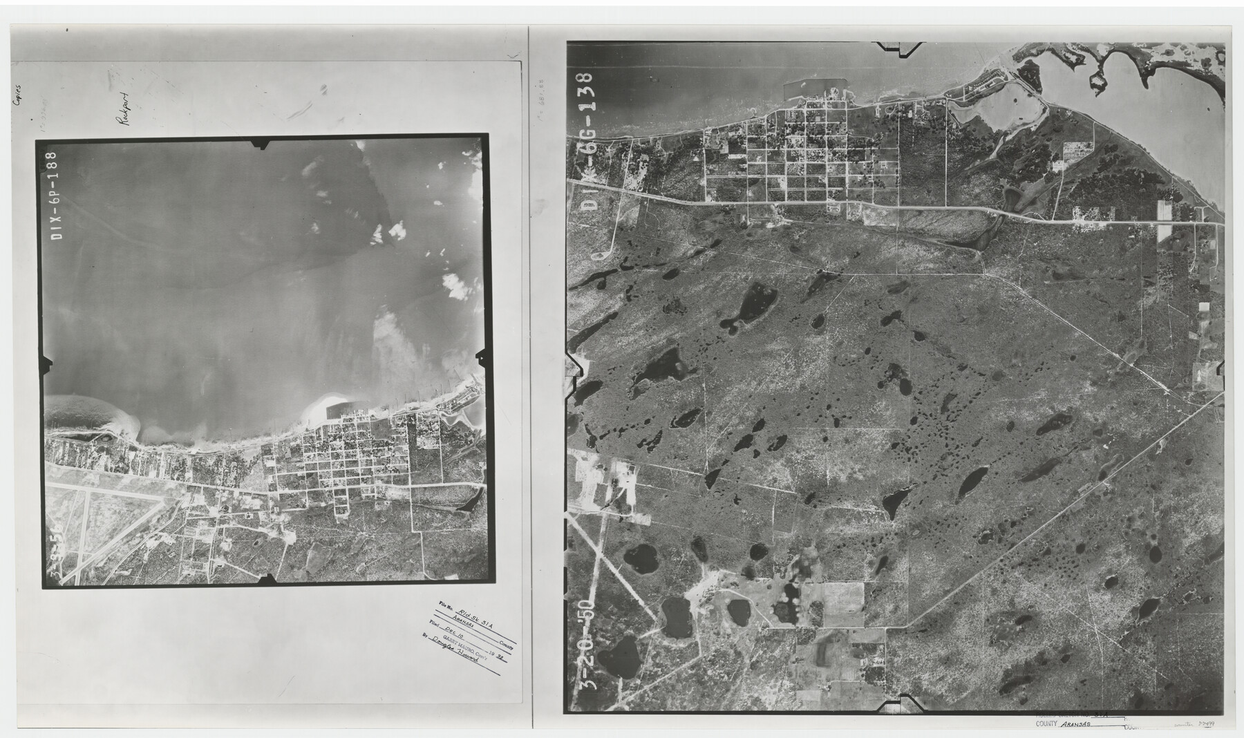
[Aerial photos of 1950 Shoreline of Aransas Bay - Frames DIX-6P-188 and DIX-6G-138]
-
Map/Doc
77499
-
Collection
General Map Collection
-
Object Dates
1950 (Creation Date)
1993/12/10 (File Date)
-
Counties
Aransas
-
Subjects
Aerial Photograph Surveying Rolled Sketch
-
Height x Width
25.1 x 42.4 inches
63.8 x 107.7 cm
-
Medium
photograph
Part of: General Map Collection
Reeves County Working Sketch 20

Print $40.00
- Digital $50.00
Reeves County Working Sketch 20
1964
Size 37.6 x 50.4 inches
Map/Doc 63463
Parker County Sketch File 17

Print $6.00
- Digital $50.00
Parker County Sketch File 17
Size 10.7 x 9.5 inches
Map/Doc 33552
[Maps of surveys in Reeves & Culberson Cos]
![61136, [Maps of surveys in Reeves & Culberson Cos], General Map Collection](https://historictexasmaps.com/wmedia_w700/maps/61136.tif.jpg)
Print $20.00
- Digital $50.00
[Maps of surveys in Reeves & Culberson Cos]
1937
Size 30.5 x 24.7 inches
Map/Doc 61136
Brewster County Sketch File S-36

Print $80.00
- Digital $50.00
Brewster County Sketch File S-36
1986
Size 14.4 x 8.8 inches
Map/Doc 15865
San Patricio County Rolled Sketch 37

Print $127.00
- Digital $50.00
San Patricio County Rolled Sketch 37
Size 10.3 x 15.2 inches
Map/Doc 48888

El Paso County Rolled Sketch 2A

Print $20.00
- Digital $50.00
El Paso County Rolled Sketch 2A
1889
Size 24.1 x 32.8 inches
Map/Doc 5821
Harris County Working Sketch 110

Print $20.00
- Digital $50.00
Harris County Working Sketch 110
1982
Size 21.3 x 22.0 inches
Map/Doc 66002
Baylor County

Print $20.00
- Digital $50.00
Baylor County
1961
Size 40.6 x 33.0 inches
Map/Doc 77209
Flight Mission No. BRE-1P, Frame 30, Nueces County

Print $20.00
- Digital $50.00
Flight Mission No. BRE-1P, Frame 30, Nueces County
1956
Size 18.4 x 22.3 inches
Map/Doc 86626
Harrison County Sketch File 2

Print $4.00
- Digital $50.00
Harrison County Sketch File 2
1853
Size 8.1 x 9.9 inches
Map/Doc 26034
United States - Gulf Coast - Galveston to Rio Grande

Print $20.00
- Digital $50.00
United States - Gulf Coast - Galveston to Rio Grande
1919
Size 27.2 x 18.2 inches
Map/Doc 72750
You may also like
Nacogdoches County Sketch File 16

Print $20.00
- Digital $50.00
Nacogdoches County Sketch File 16
1945
Size 24.6 x 18.5 inches
Map/Doc 42155
Edwards County Rolled Sketch J

Print $83.00
- Digital $50.00
Edwards County Rolled Sketch J
1918
Size 23.6 x 30.3 inches
Map/Doc 5818
General Highway Map, Blanco County, Texas

Print $20.00
General Highway Map, Blanco County, Texas
1961
Size 25.0 x 18.2 inches
Map/Doc 79376
San Patricio County NRC Article 33.136 Sketch 3

Print $3.00
- Digital $50.00
San Patricio County NRC Article 33.136 Sketch 3
Size 17.0 x 11.0 inches
Map/Doc 94694
Schleicher County Working Sketch Graphic Index

Print $40.00
- Digital $50.00
Schleicher County Working Sketch Graphic Index
1940
Size 37.8 x 54.2 inches
Map/Doc 76694
Shallow Water Country of Northwest Texas

Shallow Water Country of Northwest Texas
1916
Map/Doc 96758
Orange County Boundary File 1

Print $4.00
- Digital $50.00
Orange County Boundary File 1
Size 9.7 x 6.3 inches
Map/Doc 57773
Henderson County

Print $40.00
- Digital $50.00
Henderson County
1922
Size 39.3 x 49.1 inches
Map/Doc 4683
Nueces County Sketch File 36

Print $20.00
- Digital $50.00
Nueces County Sketch File 36
1913
Size 17.0 x 18.4 inches
Map/Doc 42189
Guadalupe County Working Sketch 11

Print $40.00
- Digital $50.00
Guadalupe County Working Sketch 11
1972
Size 67.7 x 45.0 inches
Map/Doc 63320
Grayson County Working Sketch 7

Print $20.00
- Digital $50.00
Grayson County Working Sketch 7
1940
Size 41.1 x 27.7 inches
Map/Doc 63246
Brewster County Working Sketch 86

Print $20.00
- Digital $50.00
Brewster County Working Sketch 86
1973
Size 27.6 x 27.7 inches
Map/Doc 67686