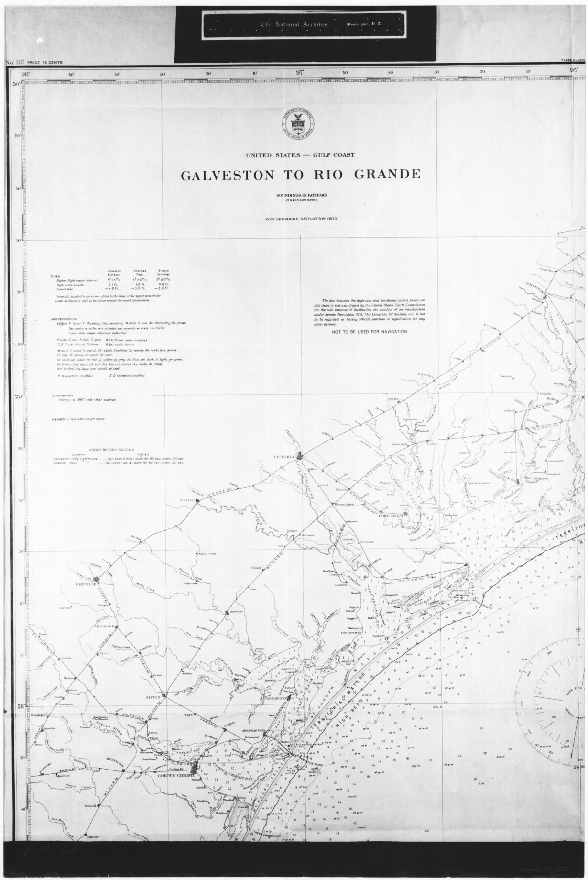
United States - Gulf Coast - Galveston to Rio Grande
RL-2-4b
-
Map/Doc
72750
-
Collection
General Map Collection
-
Object Dates
1919 (Creation Date)
-
People and Organizations
U. S. Coast and Geodetic Survey (Publisher)
-
Subjects
Nautical Charts
-
Height x Width
27.2 x 18.2 inches
69.1 x 46.2 cm
-
Comments
B/W photostat copy from National Archives in multiple pieces.
Part of: General Map Collection
Hall County Working Sketch 9

Print $20.00
- Digital $50.00
Hall County Working Sketch 9
1972
Size 36.9 x 39.4 inches
Map/Doc 63337
Glasscock County Working Sketch 10

Print $40.00
- Digital $50.00
Glasscock County Working Sketch 10
1957
Size 77.9 x 37.2 inches
Map/Doc 63183
Coleman County

Print $20.00
- Digital $50.00
Coleman County
1862
Size 22.5 x 21.6 inches
Map/Doc 3414
Brooks County Working Sketch 14

Print $20.00
- Digital $50.00
Brooks County Working Sketch 14
1944
Size 29.2 x 20.0 inches
Map/Doc 67798
Map of Power and Hewetson Colony

Print $20.00
- Digital $50.00
Map of Power and Hewetson Colony
1841
Size 34.8 x 24.3 inches
Map/Doc 1950
Bailey County Sketch File 3a

Print $12.00
- Digital $50.00
Bailey County Sketch File 3a
1901
Size 8.1 x 9.0 inches
Map/Doc 13948
Zavala County Working Sketch 7

Print $20.00
- Digital $50.00
Zavala County Working Sketch 7
1948
Size 19.3 x 17.3 inches
Map/Doc 62082
Harris County Sketch File 52

Print $20.00
- Digital $50.00
Harris County Sketch File 52
1914
Size 21.7 x 26.0 inches
Map/Doc 11653
Hockley County Sketch File 3

Print $20.00
- Digital $50.00
Hockley County Sketch File 3
Size 43.1 x 35.4 inches
Map/Doc 10490
[Sketch for Mineral Applications 26885-6 - Reagan and Crockett Cos., W. H. Bland]
![2854, [Sketch for Mineral Applications 26885-6 - Reagan and Crockett Cos., W. H. Bland], General Map Collection](https://historictexasmaps.com/wmedia_w700/maps/2854.tif.jpg)
Print $20.00
- Digital $50.00
[Sketch for Mineral Applications 26885-6 - Reagan and Crockett Cos., W. H. Bland]
1932
Size 41.5 x 36.6 inches
Map/Doc 2854
Flight Mission No. CLL-1N, Frame 192, Willacy County

Print $20.00
- Digital $50.00
Flight Mission No. CLL-1N, Frame 192, Willacy County
1954
Size 18.5 x 22.2 inches
Map/Doc 87062
El Paso County Working Sketch 1
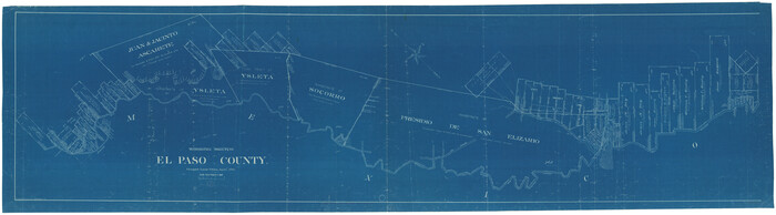
Print $40.00
- Digital $50.00
El Paso County Working Sketch 1
1911
Size 25.4 x 90.6 inches
Map/Doc 69022
You may also like
A New Map of Nebraska, Kansas, New Mexico and Indian Territories

Print $20.00
- Digital $50.00
A New Map of Nebraska, Kansas, New Mexico and Indian Territories
Size 18.6 x 15.2 inches
Map/Doc 93985

Controlled Mosaic by Jack Amman Photogrammetric Engineers, Inc - Sheet 25

Print $20.00
- Digital $50.00
Controlled Mosaic by Jack Amman Photogrammetric Engineers, Inc - Sheet 25
1954
Size 20.0 x 24.0 inches
Map/Doc 83476
The Mexican Municipality of Mina. ca. Spring 1835

Print $20.00
The Mexican Municipality of Mina. ca. Spring 1835
2020
Size 10.7 x 21.8 inches
Map/Doc 96029
Carte Générale des États-Unis Mexicains de la République du Texas et des Etats de L'Amérique Centrale
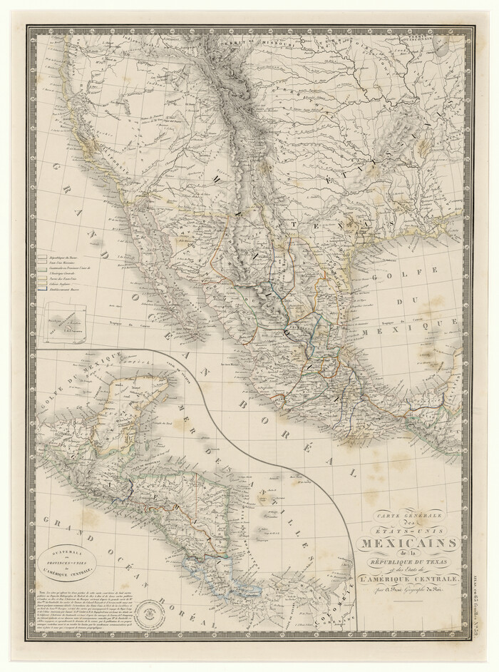
Print $20.00
- Digital $50.00
Carte Générale des États-Unis Mexicains de la République du Texas et des Etats de L'Amérique Centrale
1844
Size 21.9 x 16.3 inches
Map/Doc 97532
Presidio County Rolled Sketch 33

Print $40.00
- Digital $50.00
Presidio County Rolled Sketch 33
Size 57.7 x 42.3 inches
Map/Doc 9772
Fractional Township No. 8 South Range No. 8 East of the Indian Meridian, Indian Territory

Print $20.00
- Digital $50.00
Fractional Township No. 8 South Range No. 8 East of the Indian Meridian, Indian Territory
1898
Size 19.2 x 24.2 inches
Map/Doc 75214
Hudspeth County Working Sketch 47

Print $20.00
- Digital $50.00
Hudspeth County Working Sketch 47
1984
Size 28.4 x 41.1 inches
Map/Doc 66332
Wheeler County Working Sketch 19

Print $20.00
- Digital $50.00
Wheeler County Working Sketch 19
1986
Size 33.5 x 31.8 inches
Map/Doc 72508
Flight Mission No. BRA-8M, Frame 141, Jefferson County

Print $20.00
- Digital $50.00
Flight Mission No. BRA-8M, Frame 141, Jefferson County
1953
Size 18.8 x 22.4 inches
Map/Doc 85633
Sketch of coast of Texas, Laguna Madre from Pt. of Rocks to Corpus Christi [and accompanying letter]
![72963, Sketch of coast of Texas, Laguna Madre from Pt. of Rocks to Corpus Christi [and accompanying letter], General Map Collection](https://historictexasmaps.com/wmedia_w700/maps/72963.tif.jpg)
Print $2.00
- Digital $50.00
Sketch of coast of Texas, Laguna Madre from Pt. of Rocks to Corpus Christi [and accompanying letter]
1882
Size 11.2 x 8.8 inches
Map/Doc 72963
Crane County Working Sketch 31

Print $20.00
- Digital $50.00
Crane County Working Sketch 31
1982
Size 34.3 x 37.7 inches
Map/Doc 68308