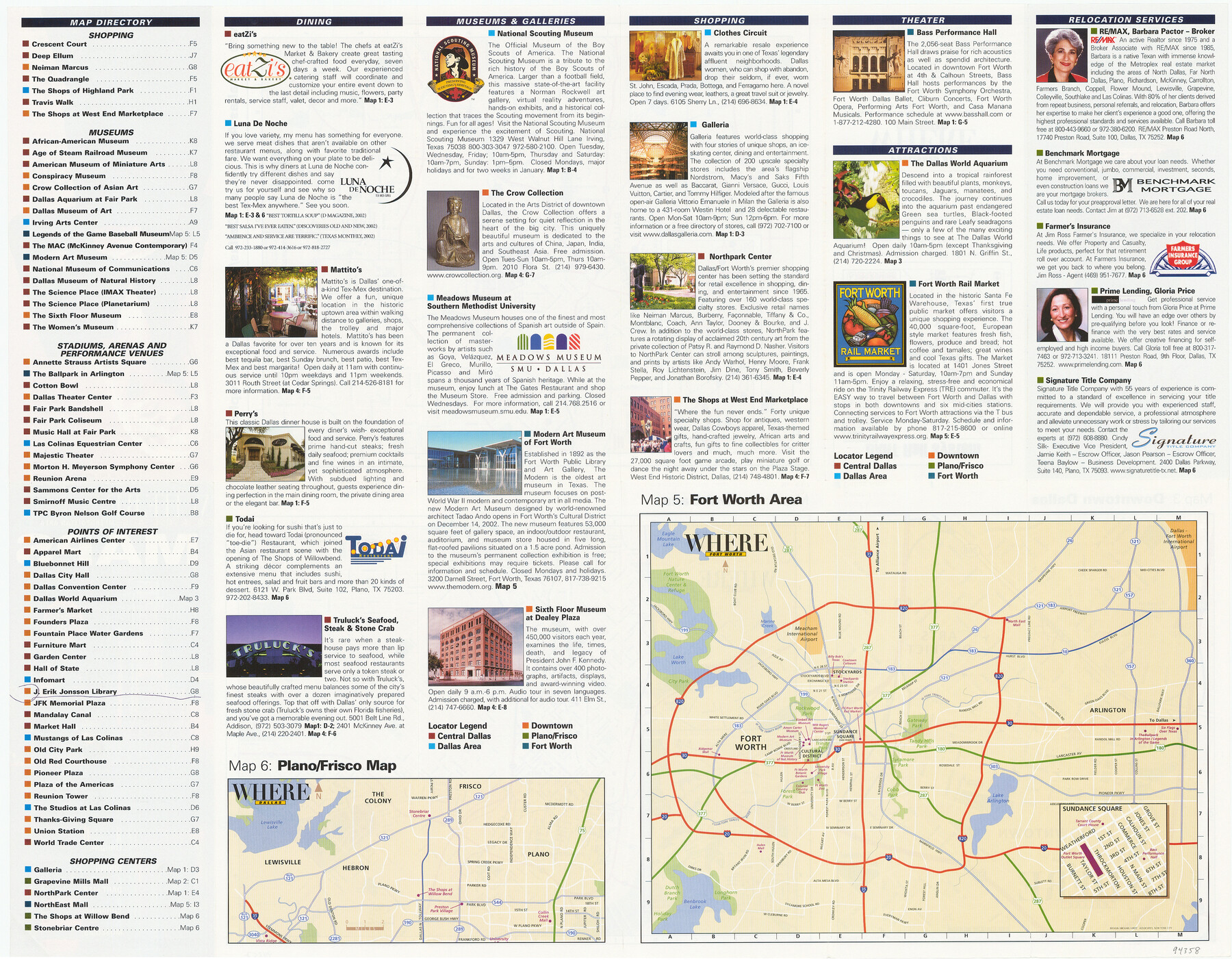
Dallas Metropolitan Area
[Verso - Fort Worth and Frisco/Plano maps]
-
Map/Doc
94358
-
Collection
General Map Collection
-
Object Dates
2003 (Edition Date)
-
People and Organizations
Where Magazine (Publisher)
-
Counties
Dallas Tarrant
-
Subjects
City
-
Height x Width
17.1 x 22.0 inches
43.4 x 55.9 cm
-
Medium
paper, etching/engraving/lithograph
-
Comments
For maps of Dallas metro area on recto, see 94357. For research only.
Related maps

Part of: General Map Collection
[Titles along the Trinity River]
![175, [Titles along the Trinity River], General Map Collection](https://historictexasmaps.com/wmedia_w700/maps/175.tif.jpg)
Print $3.00
- Digital $50.00
[Titles along the Trinity River]
Size 10.6 x 15.8 inches
Map/Doc 175
Nueces County Aerial Photograph Index Sheet 1

Print $20.00
- Digital $50.00
Nueces County Aerial Photograph Index Sheet 1
1956
Size 23.4 x 19.6 inches
Map/Doc 83736
Bandera County Rolled Sketch 5

Print $20.00
- Digital $50.00
Bandera County Rolled Sketch 5
1973
Size 19.8 x 31.0 inches
Map/Doc 5117
Newton County Working Sketch 15

Print $20.00
- Digital $50.00
Newton County Working Sketch 15
1949
Size 23.4 x 33.9 inches
Map/Doc 71261
Menard County Sketch File 2

Print $22.00
- Digital $50.00
Menard County Sketch File 2
1881
Size 7.9 x 12.8 inches
Map/Doc 31486
Arroyo Colorado, Rio Hondo Sheet

Print $40.00
- Digital $50.00
Arroyo Colorado, Rio Hondo Sheet
1929
Size 35.0 x 52.6 inches
Map/Doc 65129
Howard County Rolled Sketch 4

Print $20.00
- Digital $50.00
Howard County Rolled Sketch 4
1909
Size 35.6 x 27.4 inches
Map/Doc 6233
Val Verde County Rolled Sketch 42

Print $20.00
- Digital $50.00
Val Verde County Rolled Sketch 42
1919
Size 17.3 x 21.9 inches
Map/Doc 8116
International and Great Northern Railroad Lone Star Route and Connections

Print $20.00
- Digital $50.00
International and Great Northern Railroad Lone Star Route and Connections
1877
Size 17.3 x 23.2 inches
Map/Doc 93462
Edwards County

Print $40.00
- Digital $50.00
Edwards County
1900
Size 47.7 x 59.8 inches
Map/Doc 82082
Flight Mission No. CLL-3N, Frame 15, Willacy County

Print $20.00
- Digital $50.00
Flight Mission No. CLL-3N, Frame 15, Willacy County
1950
Size 18.4 x 22.0 inches
Map/Doc 87081
Railroad and County Map of Texas prepared and published as a supplement to the Texas Almanac and State Industrial Guide

Print $20.00
- Digital $50.00
Railroad and County Map of Texas prepared and published as a supplement to the Texas Almanac and State Industrial Guide
1910
Size 22.2 x 23.1 inches
Map/Doc 95353
You may also like
Comanche County Milam Land District

Print $20.00
- Digital $50.00
Comanche County Milam Land District
1876
Size 22.1 x 23.0 inches
Map/Doc 3433
Collingsworth County

Print $20.00
- Digital $50.00
Collingsworth County
1971
Size 42.7 x 35.8 inches
Map/Doc 95460
Hartley County

Print $20.00
- Digital $50.00
Hartley County
1925
Size 34.2 x 41.5 inches
Map/Doc 77306
Port of Corpus Christi Inner Harbor Industrial District, Nueces County Navigation District Number One

Print $40.00
- Digital $50.00
Port of Corpus Christi Inner Harbor Industrial District, Nueces County Navigation District Number One
1972
Size 43.6 x 101.3 inches
Map/Doc 78635
Pecos County Rolled Sketch 46

Print $3.00
- Digital $50.00
Pecos County Rolled Sketch 46
1913
Size 13.4 x 9.7 inches
Map/Doc 7224
Brewster County Rolled Sketch 114

Print $20.00
- Digital $50.00
Brewster County Rolled Sketch 114
1964
Size 11.5 x 17.5 inches
Map/Doc 5287
[Triangulation Net of Part of Texas. Travis County to Red River]
![3101, [Triangulation Net of Part of Texas. Travis County to Red River], General Map Collection](https://historictexasmaps.com/wmedia_w700/maps/3101.tif.jpg)
Print $20.00
- Digital $50.00
[Triangulation Net of Part of Texas. Travis County to Red River]
1928
Size 28.2 x 33.9 inches
Map/Doc 3101
Val Verde County Boundary File 2

Print $4.00
- Digital $50.00
Val Verde County Boundary File 2
Size 11.4 x 8.8 inches
Map/Doc 59575
[Rockwall County School Land and adjacent Blocks]
![90759, [Rockwall County School Land and adjacent Blocks], Twichell Survey Records](https://historictexasmaps.com/wmedia_w700/maps/90759-1.tif.jpg)
Print $20.00
- Digital $50.00
[Rockwall County School Land and adjacent Blocks]
1904
Size 16.2 x 12.6 inches
Map/Doc 90759
[North Part of T. A. Thomson, Block T]
![91075, [North Part of T. A. Thomson, Block T], Twichell Survey Records](https://historictexasmaps.com/wmedia_w700/maps/91075-1.tif.jpg)
Print $20.00
- Digital $50.00
[North Part of T. A. Thomson, Block T]
Size 17.6 x 14.3 inches
Map/Doc 91075
Stonewall County Working Sketch 5

Print $20.00
- Digital $50.00
Stonewall County Working Sketch 5
1927
Size 17.7 x 24.0 inches
Map/Doc 63999
Township 4 South Ranges 12 and 13 West, South Western District, Louisiana

Print $20.00
- Digital $50.00
Township 4 South Ranges 12 and 13 West, South Western District, Louisiana
1879
Size 19.6 x 24.7 inches
Map/Doc 65884