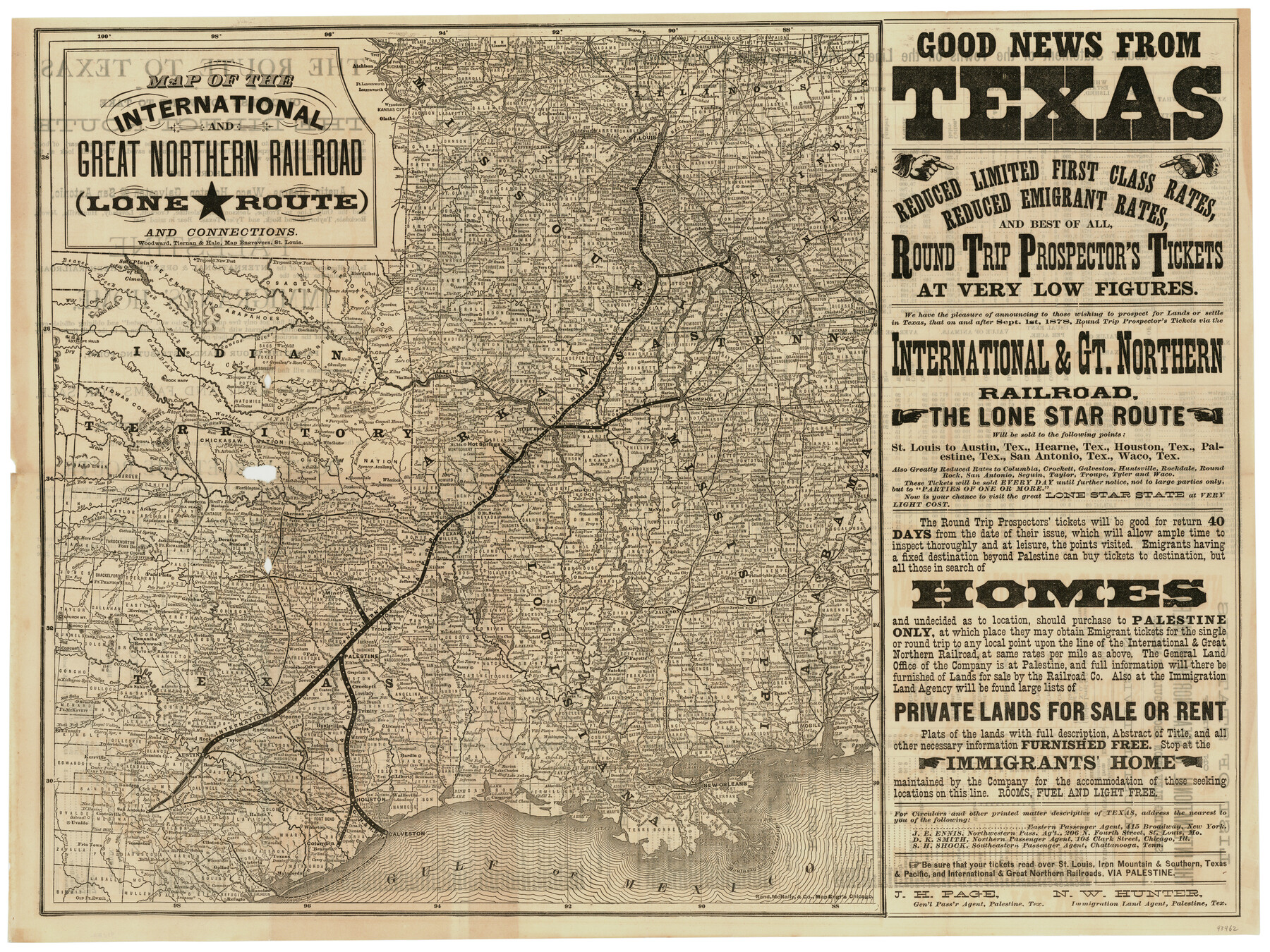
International and Great Northern Railroad Lone Star Route and Connections
-
Map/Doc
93462
-
Collection
General Map Collection
-
Object Dates
[1877] (Creation Date)
2013 (File Date)
-
People and Organizations
International and Great Northern RR. Co. (Publisher)
Woodward, Tiernan and Hale (Printer)
-
Subjects
Old Southwest Railroads
-
Height x Width
17.3 x 23.2 inches
43.9 x 58.9 cm
-
Comments
To view/download the timetables on verso and the booklet that accompanied this map, please click the "Download PDF" link above.
Part of: General Map Collection
Moore County Sketch File 12

Print $20.00
- Digital $50.00
Moore County Sketch File 12
1939
Size 27.3 x 19.9 inches
Map/Doc 42130

Dallas County Sketch File 26

Print $20.00
- Digital $50.00
Dallas County Sketch File 26
1942
Size 24.9 x 18.9 inches
Map/Doc 11289
Pecos County Working Sketch 62

Print $40.00
- Digital $50.00
Pecos County Working Sketch 62
1952
Size 32.3 x 59.1 inches
Map/Doc 71534
Gaines County Sketch File 1

Print $20.00
- Digital $50.00
Gaines County Sketch File 1
Size 19.1 x 30.7 inches
Map/Doc 11521
Val Verde County Rolled Sketch 59

Print $20.00
- Digital $50.00
Val Verde County Rolled Sketch 59
1947
Size 45.2 x 23.6 inches
Map/Doc 10078
Presidio County Rolled Sketch 92

Print $20.00
- Digital $50.00
Presidio County Rolled Sketch 92
1947
Size 18.5 x 18.9 inches
Map/Doc 7377
Culberson County Working Sketch 65

Print $40.00
- Digital $50.00
Culberson County Working Sketch 65
1975
Size 49.0 x 34.9 inches
Map/Doc 68519
[Surveys in Power and Hewetson's Colony]
![2, [Surveys in Power and Hewetson's Colony], General Map Collection](https://historictexasmaps.com/wmedia_w700/maps/2.tif.jpg)
Print $20.00
- Digital $50.00
[Surveys in Power and Hewetson's Colony]
1830
Size 21.3 x 22.5 inches
Map/Doc 2
Matagorda County Sketch File 36

Print $6.00
- Digital $50.00
Matagorda County Sketch File 36
Size 12.1 x 8.3 inches
Map/Doc 30827
Webb County Sketch File 9a

Print $20.00
- Digital $50.00
Webb County Sketch File 9a
1930
Size 31.4 x 23.9 inches
Map/Doc 12619
Hemphill County Working Sketch 26

Print $40.00
- Digital $50.00
Hemphill County Working Sketch 26
1974
Size 57.2 x 48.3 inches
Map/Doc 66121
You may also like
Hood County Sketch File 27

Print $4.00
- Digital $50.00
Hood County Sketch File 27
1873
Size 12.9 x 8.5 inches
Map/Doc 26629
Map of Texas Compiled from Surveys recorded in the Land Office of Texas

Print $20.00
- Digital $50.00
Map of Texas Compiled from Surveys recorded in the Land Office of Texas
1841
Size 26.4 x 22.3 inches
Map/Doc 538
Flake Addition a Subdivision of SE Part of NE Quarter Section 4, Block O

Print $20.00
- Digital $50.00
Flake Addition a Subdivision of SE Part of NE Quarter Section 4, Block O
Size 27.4 x 19.5 inches
Map/Doc 92823
Goliad County Working Sketch 7

Print $20.00
- Digital $50.00
Goliad County Working Sketch 7
1937
Size 35.0 x 32.9 inches
Map/Doc 63197
Calhoun County Aerial Photograph Index Sheet 4

Print $20.00
- Digital $50.00
Calhoun County Aerial Photograph Index Sheet 4
1953
Size 24.2 x 19.7 inches
Map/Doc 87211
Fannin County Working Sketch 10

Print $20.00
- Digital $50.00
Fannin County Working Sketch 10
1989
Size 26.5 x 38.0 inches
Map/Doc 69164
Map of the State of Texas Showing Original Land Districts

Print $20.00
- Digital $50.00
Map of the State of Texas Showing Original Land Districts
1891
Size 42.2 x 42.4 inches
Map/Doc 2138
Erath County Sketch File 7

Print $4.00
- Digital $50.00
Erath County Sketch File 7
Size 6.8 x 7.3 inches
Map/Doc 22267
Val Verde County Rolled Sketch 40

Print $40.00
- Digital $50.00
Val Verde County Rolled Sketch 40
Size 39.0 x 123.5 inches
Map/Doc 10073
Flight Mission No. DQN-7K, Frame 92, Calhoun County

Print $20.00
- Digital $50.00
Flight Mission No. DQN-7K, Frame 92, Calhoun County
1953
Size 17.2 x 19.1 inches
Map/Doc 84483
Matagorda Bay Including Lavaca and Tres Palacios Bays

Print $20.00
- Digital $50.00
Matagorda Bay Including Lavaca and Tres Palacios Bays
1975
Size 37.2 x 47.7 inches
Map/Doc 73364
Arroyo Colorado, Rio Hondo Sheet

Print $40.00
- Digital $50.00
Arroyo Colorado, Rio Hondo Sheet
1929
Size 35.0 x 52.6 inches
Map/Doc 65129