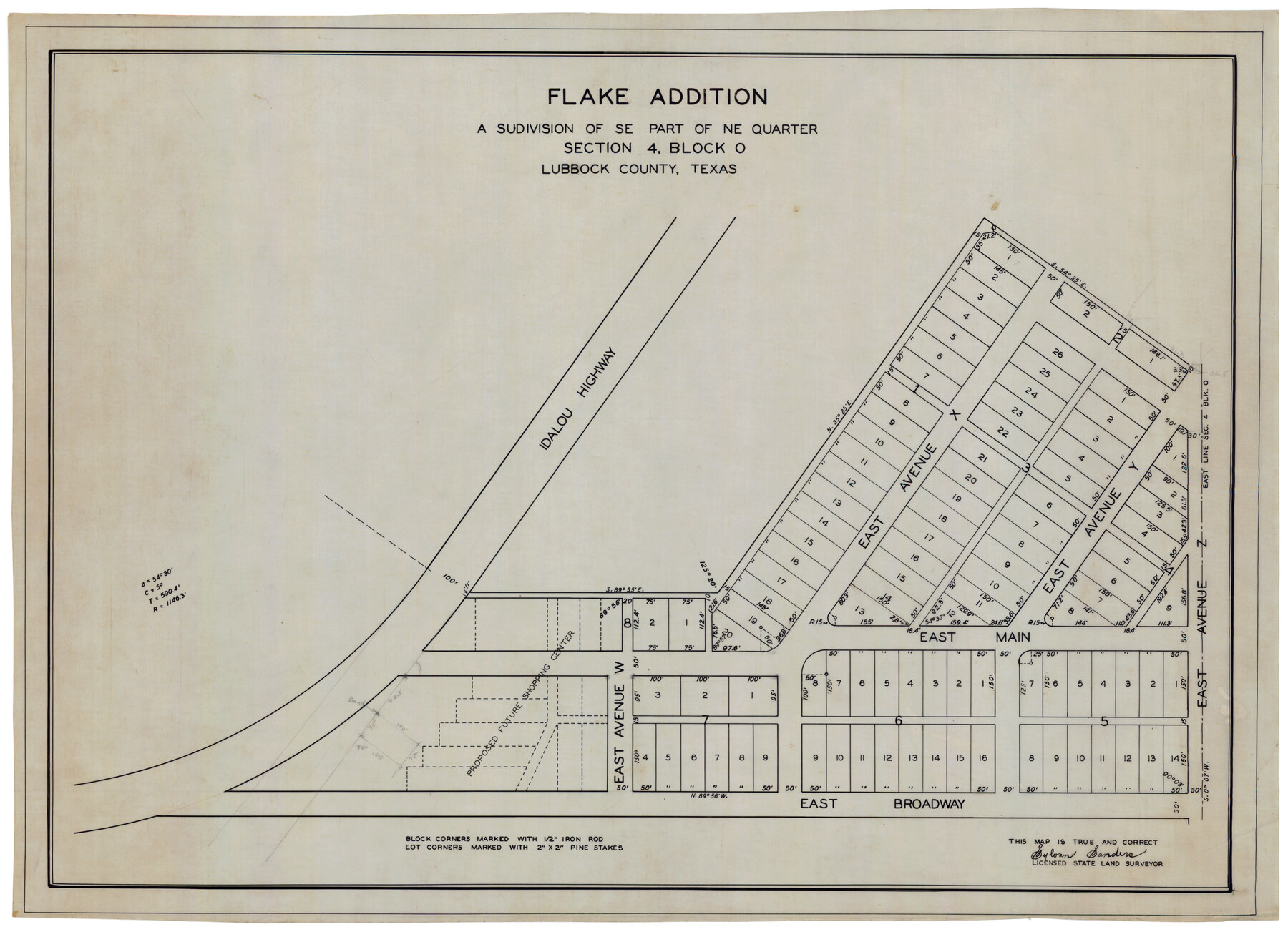
Flake Addition a Subdivision of SE Part of NE Quarter Section 4, Block O
-
Map/Doc
92823
-
Collection
Twichell Survey Records
-
People and Organizations
Sylvan Sanders (Surveyor/Engineer)
-
Counties
Lubbock
-
Height x Width
27.4 x 19.5 inches
69.6 x 49.5 cm
Part of: Twichell Survey Records
[Sketch showing Block M-3]
![91708, [Sketch showing Block M-3], Twichell Survey Records](https://historictexasmaps.com/wmedia_w700/maps/91708-1.tif.jpg)
Print $20.00
- Digital $50.00
[Sketch showing Block M-3]
Size 7.0 x 21.2 inches
Map/Doc 91708
![92466, [Muleshoe], Twichell Survey Records](https://historictexasmaps.com/wmedia_w700/maps/92466-1.tif.jpg)
[Jas. T. Williams Survey and vicinity]
![91263, [Jas. T. Williams Survey and vicinity], Twichell Survey Records](https://historictexasmaps.com/wmedia_w700/maps/91263-1.tif.jpg)
Print $20.00
- Digital $50.00
[Jas. T. Williams Survey and vicinity]
Size 27.0 x 22.1 inches
Map/Doc 91263
Petersburg, Hale County, Texas

Print $20.00
- Digital $50.00
Petersburg, Hale County, Texas
1927
Size 16.1 x 28.4 inches
Map/Doc 92699
Working Sketch Crockett County

Print $20.00
- Digital $50.00
Working Sketch Crockett County
1924
Size 33.3 x 37.6 inches
Map/Doc 90318
[School Leagues in Bailey and Lamb County]
![90987, [School Leagues in Bailey and Lamb County], Twichell Survey Records](https://historictexasmaps.com/wmedia_w700/maps/90987-2.tif.jpg)
Print $20.00
- Digital $50.00
[School Leagues in Bailey and Lamb County]
Size 30.5 x 25.2 inches
Map/Doc 90987
Crosbyton (Jeff Williams Plan)

Print $20.00
- Digital $50.00
Crosbyton (Jeff Williams Plan)
Size 26.0 x 18.2 inches
Map/Doc 92126
[H. & O. B. Blocks 1, B9, 24, J]
![90345, [H. & O. B. Blocks 1, B9, 24, J], Twichell Survey Records](https://historictexasmaps.com/wmedia_w700/maps/90345-1.tif.jpg)
Print $20.00
- Digital $50.00
[H. & O. B. Blocks 1, B9, 24, J]
Size 25.2 x 23.6 inches
Map/Doc 90345
[Sketch of part of G. & M. Block 5, G. & M. Block 4, Block M19 and Block 21W]
![93081, [Sketch of part of G. & M. Block 5, G. & M. Block 4, Block M19 and Block 21W], Twichell Survey Records](https://historictexasmaps.com/wmedia_w700/maps/93081-1.tif.jpg)
Print $20.00
- Digital $50.00
[Sketch of part of G. & M. Block 5, G. & M. Block 4, Block M19 and Block 21W]
Size 21.7 x 16.6 inches
Map/Doc 93081
[Sketch of area just south of Levi Pruitt survey]
![91854, [Sketch of area just south of Levi Pruitt survey], Twichell Survey Records](https://historictexasmaps.com/wmedia_w700/maps/91854-1.tif.jpg)
Print $20.00
- Digital $50.00
[Sketch of area just south of Levi Pruitt survey]
Size 24.9 x 18.6 inches
Map/Doc 91854
J. W. Kendrick Land, Crosby County, Texas

Print $20.00
- Digital $50.00
J. W. Kendrick Land, Crosby County, Texas
Size 42.8 x 33.7 inches
Map/Doc 92603
[Sketch to determine conflict between H. & T. C. Blk. 97 and T. & P. Ry. Co. Blk. 30]
![90139, [Sketch to determine conflict between H. & T. C. Blk. 97 and T. & P. Ry. Co. Blk. 30], Twichell Survey Records](https://historictexasmaps.com/wmedia_w700/maps/90139-1.tif.jpg)
Print $20.00
- Digital $50.00
[Sketch to determine conflict between H. & T. C. Blk. 97 and T. & P. Ry. Co. Blk. 30]
1903
Size 19.1 x 26.9 inches
Map/Doc 90139
You may also like
PSL Field Notes for Blocks C1, C2, and C3 in Pecos and Reeves Counties

PSL Field Notes for Blocks C1, C2, and C3 in Pecos and Reeves Counties
Map/Doc 81669
Guadalupe County Working Sketch 6

Print $20.00
- Digital $50.00
Guadalupe County Working Sketch 6
1948
Size 24.0 x 19.7 inches
Map/Doc 63315
Flight Mission No. DCL-7C, Frame 29, Kenedy County

Print $20.00
- Digital $50.00
Flight Mission No. DCL-7C, Frame 29, Kenedy County
1943
Size 15.3 x 15.2 inches
Map/Doc 86021
[Location St. L. & S. W. R. R. Through Cherokee County]
![64045, [Location St. L. & S. W. R. R. Through Cherokee County], General Map Collection](https://historictexasmaps.com/wmedia_w700/maps/64045-1.tif.jpg)
Print $40.00
- Digital $50.00
[Location St. L. & S. W. R. R. Through Cherokee County]
Size 38.7 x 76.6 inches
Map/Doc 64045
Red River County Working Sketch 14

Print $20.00
- Digital $50.00
Red River County Working Sketch 14
1952
Size 37.8 x 22.9 inches
Map/Doc 71997
The Texas and Oklahoma Official Railway & Hotel Guide Map

Print $20.00
- Digital $50.00
The Texas and Oklahoma Official Railway & Hotel Guide Map
1906
Size 23.4 x 23.7 inches
Map/Doc 95892
[Sketch for Mineral Application 15273 - Sabine River Bed]
![65576, [Sketch for Mineral Application 15273 - Sabine River Bed], General Map Collection](https://historictexasmaps.com/wmedia_w700/maps/65576.tif.jpg)
Print $20.00
- Digital $50.00
[Sketch for Mineral Application 15273 - Sabine River Bed]
1926
Size 45.4 x 28.1 inches
Map/Doc 65576
Bee County Working Sketch 3

Print $20.00
- Digital $50.00
Bee County Working Sketch 3
1915
Size 22.8 x 20.3 inches
Map/Doc 67253
[Sketch highlighting Bob Reid and Fred Turner surveys]
![91693, [Sketch highlighting Bob Reid and Fred Turner surveys], Twichell Survey Records](https://historictexasmaps.com/wmedia_w700/maps/91693-1.tif.jpg)
Print $20.00
- Digital $50.00
[Sketch highlighting Bob Reid and Fred Turner surveys]
Size 12.5 x 17.8 inches
Map/Doc 91693
Map of Dallas County Showing Location of Texas and Pacific Railway

Print $20.00
- Digital $50.00
Map of Dallas County Showing Location of Texas and Pacific Railway
1872
Size 25.2 x 21.4 inches
Map/Doc 64134
Northeast Part of Crockett County

Print $20.00
- Digital $50.00
Northeast Part of Crockett County
1976
Size 35.6 x 47.0 inches
Map/Doc 95469
Harris County Historic Topographic 7

Print $20.00
- Digital $50.00
Harris County Historic Topographic 7
1916
Size 20.4 x 23.4 inches
Map/Doc 65817