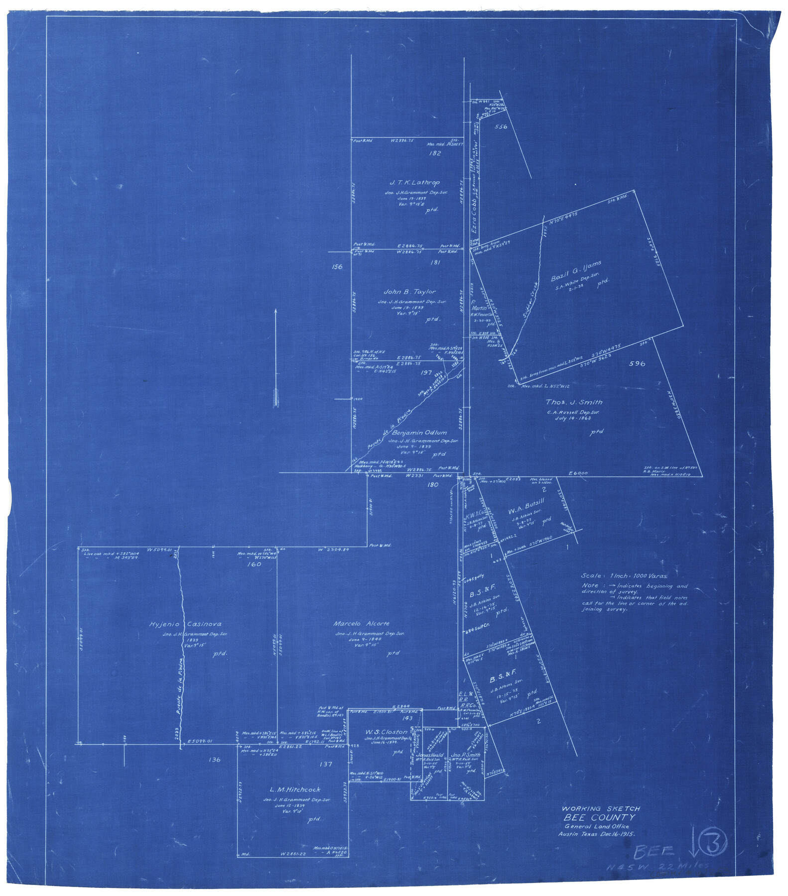
Bee County Working Sketch 3
-
Map/Doc
67253
-
Collection
General Map Collection
-
Object Dates
12/16/1915 (Creation Date)
-
People and Organizations
Texas General Land Office (Publisher)
-
Counties
Bee
-
Subjects
Surveying Working Sketch
-
Height x Width
22.8 x 20.3 inches
57.9 x 51.6 cm
-
Scale
1" = 1000 varas
-
Comments
Surveys located about 22 miles North 45 degrees West of Beeville, Texas.
Part of: General Map Collection
Travis County Sketch File 31

Print $4.00
- Digital $50.00
Travis County Sketch File 31
1889
Size 12.9 x 8.8 inches
Map/Doc 38345
Austin County Working Sketch Graphic Index

Print $20.00
- Digital $50.00
Austin County Working Sketch Graphic Index
1943
Size 38.6 x 41.1 inches
Map/Doc 76459
United States and Additions, 1820

Print $20.00
- Digital $50.00
United States and Additions, 1820
1820
Size 21.8 x 27.0 inches
Map/Doc 93798
Andrews County Sketch File 8a

Print $8.00
- Digital $50.00
Andrews County Sketch File 8a
1943
Size 11.3 x 8.8 inches
Map/Doc 12849
Brown County Sketch File 27

Print $4.00
- Digital $50.00
Brown County Sketch File 27
1868
Size 13.3 x 8.1 inches
Map/Doc 16624
Zapata County Rolled Sketch 20

Print $40.00
- Digital $50.00
Zapata County Rolled Sketch 20
1956
Size 21.2 x 49.1 inches
Map/Doc 10171
Medina County Rolled Sketch 12

Print $20.00
- Digital $50.00
Medina County Rolled Sketch 12
1979
Size 20.9 x 14.7 inches
Map/Doc 6746
Rio Grande, Hidalgo Sheet

Print $20.00
- Digital $50.00
Rio Grande, Hidalgo Sheet
1937
Size 36.8 x 36.8 inches
Map/Doc 65122
Pecos County Sketch File 94

Print $20.00
- Digital $50.00
Pecos County Sketch File 94
1956
Size 25.8 x 17.3 inches
Map/Doc 12185
Williamson County Sketch File 5

Print $13.00
- Digital $50.00
Williamson County Sketch File 5
1847
Size 8.2 x 11.2 inches
Map/Doc 40306
Tom Green County Working Sketch 14

Print $20.00
- Digital $50.00
Tom Green County Working Sketch 14
1982
Size 32.7 x 22.7 inches
Map/Doc 69383
Jones County Sketch File 5

Print $4.00
- Digital $50.00
Jones County Sketch File 5
1859
Size 10.0 x 8.1 inches
Map/Doc 28492
You may also like
Brazoria County Sketch File 21

Print $4.00
- Digital $50.00
Brazoria County Sketch File 21
Size 8.3 x 7.5 inches
Map/Doc 15016
Wilson County Working Sketch 13

Print $40.00
- Digital $50.00
Wilson County Working Sketch 13
1985
Size 23.9 x 53.5 inches
Map/Doc 72593
Crosby County Sketch File 25

Print $12.00
- Digital $50.00
Crosby County Sketch File 25
1912
Size 11.2 x 8.7 inches
Map/Doc 20093
Brewster County Working Sketch 16

Print $20.00
- Digital $50.00
Brewster County Working Sketch 16
1930
Size 42.0 x 40.1 inches
Map/Doc 67550
Goliad County Sketch File 19

Print $10.00
- Digital $50.00
Goliad County Sketch File 19
Size 12.9 x 8.0 inches
Map/Doc 24260
Jefferson County NRC Article 33.136 Sketch 1

Print $20.00
- Digital $50.00
Jefferson County NRC Article 33.136 Sketch 1
2002
Size 24.0 x 36.1 inches
Map/Doc 61601
USGS Topographic, De Kalb NW, Texas Quadrangle

Print $20.00
- Digital $50.00
USGS Topographic, De Kalb NW, Texas Quadrangle
1950
Size 26.8 x 21.6 inches
Map/Doc 77604
Cass County Working Sketch 34

Print $20.00
- Digital $50.00
Cass County Working Sketch 34
1982
Size 21.1 x 24.6 inches
Map/Doc 67937
Sherman County Sketch File 7

Print $2.00
- Digital $50.00
Sherman County Sketch File 7
1993
Size 14.6 x 9.0 inches
Map/Doc 36725
Sutton County Rolled Sketch 71

Print $20.00
- Digital $50.00
Sutton County Rolled Sketch 71
Size 23.1 x 35.3 inches
Map/Doc 83760
Jackson County Sketch File 27

Print $20.00
- Digital $50.00
Jackson County Sketch File 27
1938
Size 25.6 x 24.8 inches
Map/Doc 11847
Flight Mission No. BQY-4M, Frame 35, Harris County

Print $20.00
- Digital $50.00
Flight Mission No. BQY-4M, Frame 35, Harris County
1953
Size 18.7 x 22.5 inches
Map/Doc 85250