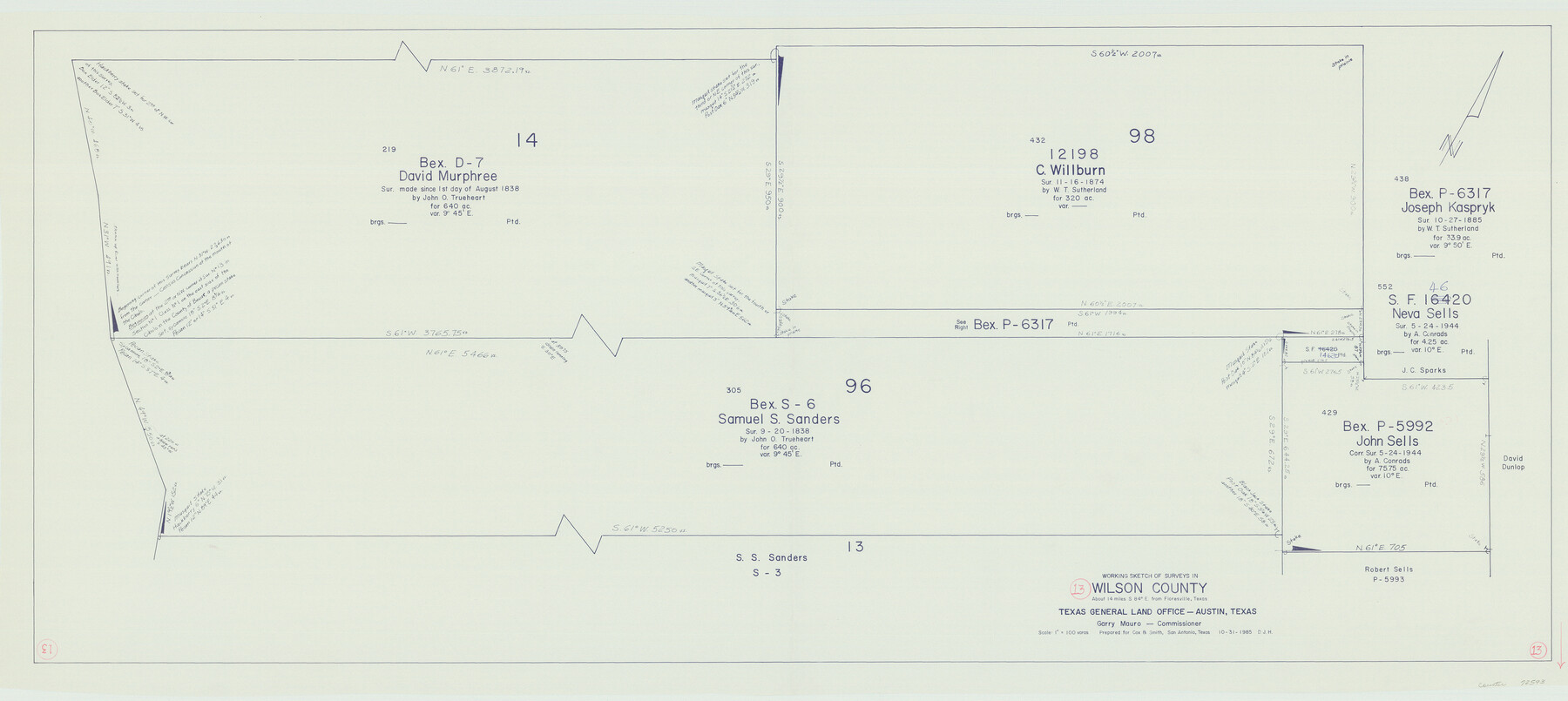
Wilson County Working Sketch 13
-
Map/Doc
72593
-
Collection
General Map Collection
-
Object Dates
10/31/1985 (Creation Date)
-
People and Organizations
Douglas Howard (Draftsman)
-
Counties
Wilson
-
Subjects
Surveying Working Sketch
-
Height x Width
23.9 x 53.5 inches
60.7 x 135.9 cm
-
Scale
1" = 100 varas
Part of: General Map Collection
San Saba County Working Sketch 9

Print $20.00
- Digital $50.00
San Saba County Working Sketch 9
1983
Size 33.8 x 42.8 inches
Map/Doc 63797
Fannin County Boundary File 1a

Print $40.00
- Digital $50.00
Fannin County Boundary File 1a
1882
Size 36.5 x 9.5 inches
Map/Doc 53279
Blanco County Sketch File 18

Print $4.00
- Digital $50.00
Blanco County Sketch File 18
1877
Size 12.6 x 8.5 inches
Map/Doc 14594

Presidio County Boundary File 2

Print $8.00
- Digital $50.00
Presidio County Boundary File 2
Size 14.0 x 8.6 inches
Map/Doc 58054
Hudspeth County Sketch File 29

Print $20.00
- Digital $50.00
Hudspeth County Sketch File 29
1918
Size 22.3 x 21.4 inches
Map/Doc 11804
Flight Mission No. CRK-5P, Frame 161, Refugio County

Print $20.00
- Digital $50.00
Flight Mission No. CRK-5P, Frame 161, Refugio County
1956
Size 18.5 x 22.4 inches
Map/Doc 86942
Sabine River, Rocky Point Crossing Sheet

Print $4.00
- Digital $50.00
Sabine River, Rocky Point Crossing Sheet
Size 24.0 x 24.6 inches
Map/Doc 65134
Coke County Rolled Sketch 10

Print $20.00
- Digital $50.00
Coke County Rolled Sketch 10
1949
Size 25.3 x 15.0 inches
Map/Doc 5509
Map of The Surveyed Part of Peters Colony Texas

Print $40.00
- Digital $50.00
Map of The Surveyed Part of Peters Colony Texas
1858
Size 45.6 x 58.5 inches
Map/Doc 1982
Bosque County Sketch File 20

Print $4.00
- Digital $50.00
Bosque County Sketch File 20
1863
Size 11.8 x 7.7 inches
Map/Doc 14796
Lubbock County Sketch File 11

Print $22.00
- Digital $50.00
Lubbock County Sketch File 11
1914
Size 11.2 x 8.8 inches
Map/Doc 30434
You may also like
Chocolate Bayou, Texas showing proposed connection from its mouth to West Galveston Bay for a Light Draft Navigation

Print $20.00
- Digital $50.00
Chocolate Bayou, Texas showing proposed connection from its mouth to West Galveston Bay for a Light Draft Navigation
Size 13.2 x 20.4 inches
Map/Doc 96557
Presidio County Rolled Sketch 68

Print $20.00
- Digital $50.00
Presidio County Rolled Sketch 68
1927
Size 11.8 x 24.4 inches
Map/Doc 7358
Collin County Rolled Sketch 2

Print $20.00
- Digital $50.00
Collin County Rolled Sketch 2
Size 33.3 x 26.1 inches
Map/Doc 8636
Flight Mission No. CGI-3N, Frame 144, Cameron County

Print $20.00
- Digital $50.00
Flight Mission No. CGI-3N, Frame 144, Cameron County
1954
Size 18.8 x 22.4 inches
Map/Doc 84617
Dawson County Sketch File 5

Print $38.00
- Digital $50.00
Dawson County Sketch File 5
1924
Size 13.4 x 8.9 inches
Map/Doc 20509
Jim Hogg County

Print $20.00
- Digital $50.00
Jim Hogg County
1962
Size 41.3 x 30.0 inches
Map/Doc 73197
Flight Mission No. DQO-3K, Frame 35, Galveston County

Print $20.00
- Digital $50.00
Flight Mission No. DQO-3K, Frame 35, Galveston County
1952
Size 18.8 x 22.5 inches
Map/Doc 85076
Morris County Rolled Sketch 2A

Print $20.00
- Digital $50.00
Morris County Rolled Sketch 2A
Size 24.2 x 19.0 inches
Map/Doc 10253
Presidio County Rolled Sketch 83A

Print $20.00
- Digital $50.00
Presidio County Rolled Sketch 83A
1930
Size 28.2 x 27.6 inches
Map/Doc 7370
Bowie County Working Sketch 24

Print $20.00
- Digital $50.00
Bowie County Working Sketch 24
1974
Size 47.1 x 40.1 inches
Map/Doc 67428
Mills County Working Sketch 26

Print $20.00
- Digital $50.00
Mills County Working Sketch 26
1993
Size 18.2 x 26.2 inches
Map/Doc 71056
PSL Field Notes for Blocks 1 and 2, Hansford and Sherman Counties, Blocks 3 and 4, Hansford County, Blocks A1, A2, A4, A5, and A6 in Hartley County, Block C0 in Hockley, Lubbock, Lynn, and Terry Counties, and Blocks A and B in Kent County

PSL Field Notes for Blocks 1 and 2, Hansford and Sherman Counties, Blocks 3 and 4, Hansford County, Blocks A1, A2, A4, A5, and A6 in Hartley County, Block C0 in Hockley, Lubbock, Lynn, and Terry Counties, and Blocks A and B in Kent County
Map/Doc 81655