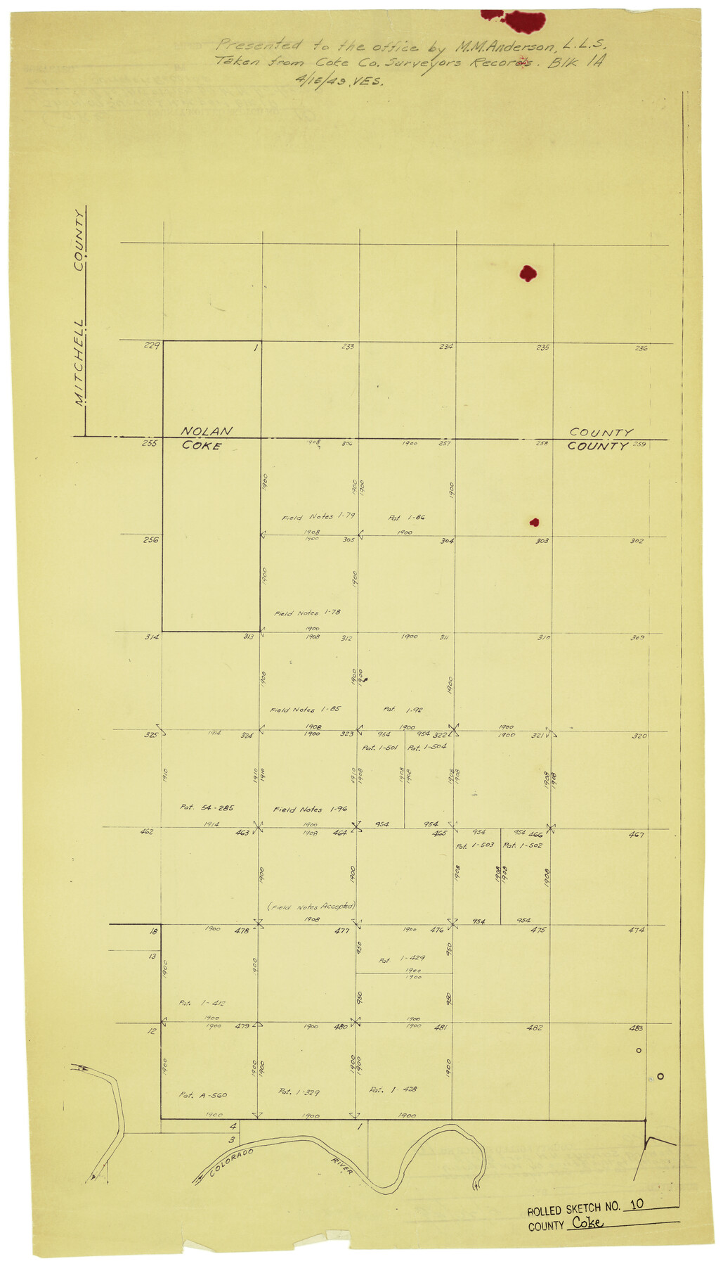
Coke County Rolled Sketch 10
[Sketch of a part of Block 1A in NW part of Coke County]
-
Map/Doc
5509
-
Collection
General Map Collection
-
Object Dates
4/15/1949 (Creation Date)
5/20/1949 (File Date)
-
People and Organizations
M.M. Anderson (Surveyor/Engineer)
-
Counties
Coke Nolan
-
Subjects
Surveying Rolled Sketch
-
Height x Width
25.3 x 15.0 inches
64.3 x 38.1 cm
-
Medium
van dyke/brownline/sepia
Part of: General Map Collection
McLennan County Sketch File 1b

Print $4.00
- Digital $50.00
McLennan County Sketch File 1b
Size 8.3 x 8.1 inches
Map/Doc 31228
San Patricio County Rolled Sketch 25

Print $40.00
- Digital $50.00
San Patricio County Rolled Sketch 25
1925
Size 37.2 x 54.1 inches
Map/Doc 9887
Kimble County Rolled Sketch 17 1/2

Print $59.00
- Digital $50.00
Kimble County Rolled Sketch 17 1/2
1889
Size 27.0 x 38.3 inches
Map/Doc 6510
Knox County Working Sketch 8

Print $20.00
- Digital $50.00
Knox County Working Sketch 8
1942
Size 38.7 x 14.3 inches
Map/Doc 70250
Flight Mission No. DIX-8P, Frame 75, Aransas County

Print $20.00
- Digital $50.00
Flight Mission No. DIX-8P, Frame 75, Aransas County
1956
Size 18.9 x 22.3 inches
Map/Doc 83906
Coryell County Sketch File 23

Print $24.00
- Digital $50.00
Coryell County Sketch File 23
1948
Size 11.2 x 8.8 inches
Map/Doc 19387

McMullen County Rolled Sketch 8

Print $20.00
- Digital $50.00
McMullen County Rolled Sketch 8
Size 26.0 x 26.3 inches
Map/Doc 6725
Johnson County Sketch File 14

Print $4.00
- Digital $50.00
Johnson County Sketch File 14
1860
Size 12.8 x 8.2 inches
Map/Doc 28450
Crockett County Working Sketch 41

Print $20.00
- Digital $50.00
Crockett County Working Sketch 41
1928
Size 20.4 x 23.2 inches
Map/Doc 68374
Portions of Galveston and East Bays and the Gulf of Mexico in Galveston County, showing Subdivision for Mineral Development

Print $20.00
- Digital $50.00
Portions of Galveston and East Bays and the Gulf of Mexico in Galveston County, showing Subdivision for Mineral Development
1978
Size 38.1 x 25.8 inches
Map/Doc 1904
1968 Texas Official State Highway Map

Digital $50.00
1968 Texas Official State Highway Map
Size 28.2 x 36.3 inches
Map/Doc 94320
You may also like
Galveston Entrance

Print $20.00
- Digital $50.00
Galveston Entrance
1867
Size 18.4 x 22.1 inches
Map/Doc 69858
Midland County Rolled Sketch 14

Print $40.00
- Digital $50.00
Midland County Rolled Sketch 14
Size 102.9 x 43.8 inches
Map/Doc 73579
The M. K. and T., Missouri, Kansas & Texas Railway

Print $20.00
- Digital $50.00
The M. K. and T., Missouri, Kansas & Texas Railway
1890
Size 25.0 x 27.9 inches
Map/Doc 95807
Menard County Working Sketch 6

Print $20.00
- Digital $50.00
Menard County Working Sketch 6
1924
Size 24.4 x 15.3 inches
Map/Doc 70953
Americae Sive Novi Orbis Nova Descriptio

Print $20.00
- Digital $50.00
Americae Sive Novi Orbis Nova Descriptio
1606
Size 16.5 x 22.4 inches
Map/Doc 93810
Henderson County Rolled Sketch 11

Print $20.00
- Digital $50.00
Henderson County Rolled Sketch 11
1915
Size 29.4 x 42.6 inches
Map/Doc 75955
Flight Mission No. DQN-2K, Frame 164, Calhoun County

Print $20.00
- Digital $50.00
Flight Mission No. DQN-2K, Frame 164, Calhoun County
1953
Size 18.7 x 22.5 inches
Map/Doc 84326
Harris County Working Sketch 1

Print $20.00
- Digital $50.00
Harris County Working Sketch 1
Size 15.8 x 15.8 inches
Map/Doc 65893
Parker County Working Sketch 8

Print $20.00
- Digital $50.00
Parker County Working Sketch 8
1956
Map/Doc 71458
Station Map, the Missouri, Kansas and Texas Ry. Of Texas - Henrietta Division

Print $20.00
- Digital $50.00
Station Map, the Missouri, Kansas and Texas Ry. Of Texas - Henrietta Division
1918
Size 11.9 x 26.9 inches
Map/Doc 64765
Young County Sketch File 10a

Print $4.00
- Digital $50.00
Young County Sketch File 10a
1879
Size 8.0 x 7.5 inches
Map/Doc 40868
[Plat of Trinity River w/ Midstream Profile in Liberty County by US Government 1899]
![65337, [Plat of Trinity River w/ Midstream Profile in Liberty County by US Government 1899], General Map Collection](https://historictexasmaps.com/wmedia_w700/maps/65337.tif.jpg)
Print $20.00
- Digital $50.00
[Plat of Trinity River w/ Midstream Profile in Liberty County by US Government 1899]
1899
Size 12.3 x 16.7 inches
Map/Doc 65337