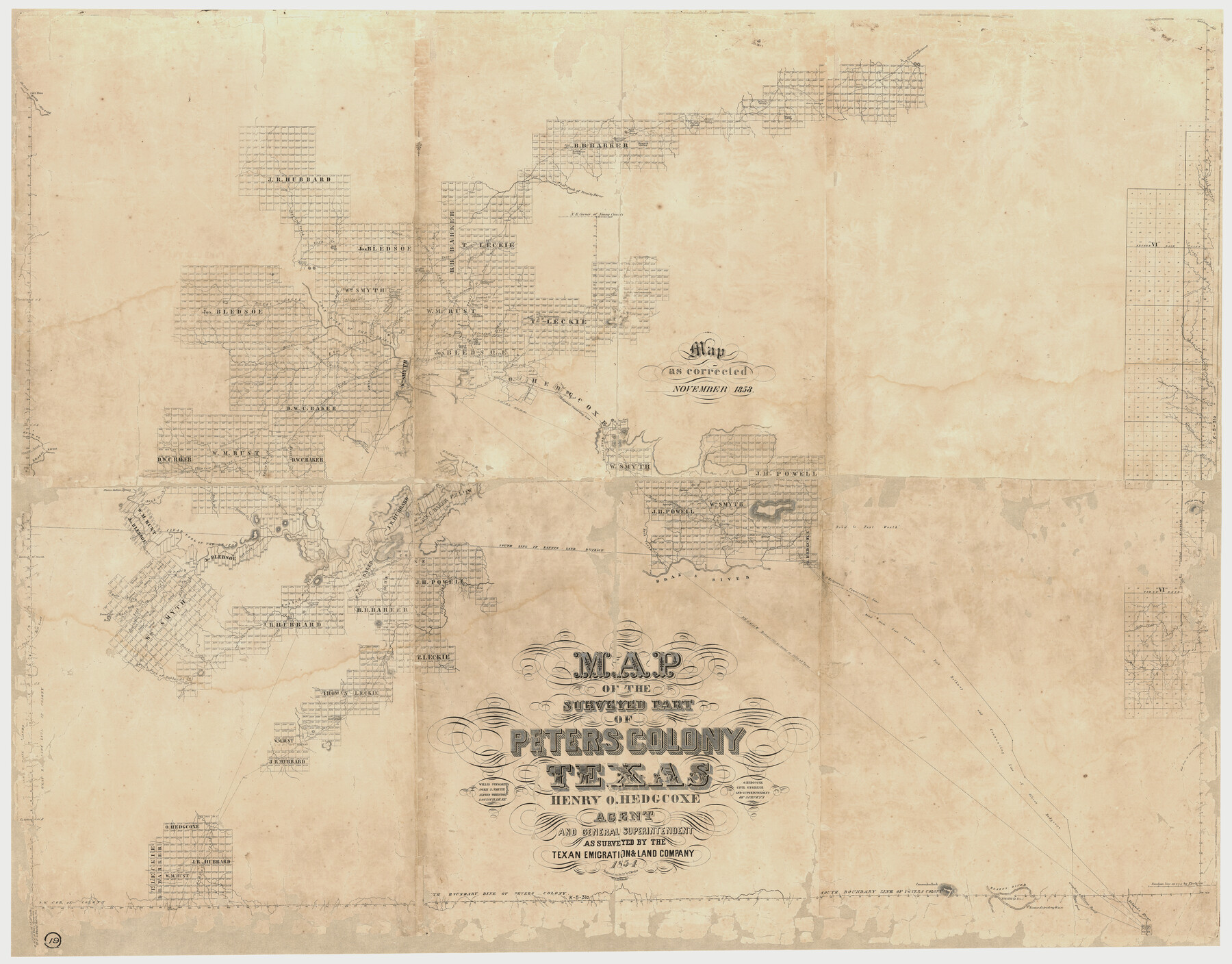
Map of The Surveyed Part of Peters Colony Texas
K-5-31a
-
Map/Doc
1982
-
Collection
General Map Collection
-
Object Dates
1858 (Creation Date)
-
People and Organizations
C. Bruder (Printer)
Henry O. Hedgcoxe (Author)
Texas Emigration and Land Company (Surveyor/Engineer)
-
Subjects
Colony
-
Height x Width
45.6 x 58.5 inches
115.8 x 148.6 cm
-
Medium
paper, etching/engraving/lithograph
-
Comments
Map originally published in 1854 but this version corrected to November 1858.
Conserved in 2018 with a donation from the Dallas Genealogy Society, Dallas, Texas. -
Features
Brazos River Salt Fork
Road from S[]svill
Road from Preston to Belknap
Grass Springs
Boggy Spring
Buffalo Spring
Prairie Spring
Post Oak Knob
Back Bone Spring
Rock Spring
Rock House Spring
Hackberry Spring
Musquite [sic] Spring
West Fork of Trinity River
Clear Creek
Spring Creek
Sand Creek
Deep Creek
West Fork of Salt Creek
East Fork of Salt Creek
California Trace
California Road
Little Salt Creek
Hickory Creek
Road from Fort Belknap to Preston Road
Fort Belknap Road
Preston Road
Lone Hill
Muddy Creek
Indian Spring
Boggy Creek
Salt Fork of the Brazos River
Wildcat Creek
Live Oak Springs
Herndon's Spring
Salt Creek
Crooked Creek
Briar Creek
Cottonwood Spring
Lost Creek
Fish Pond Mountain
Flat Top Mountain
Oak Creek
Pleasant Creek
Twin Hills
Musquite [sic] Creek
Coal Bank [Hill]
Coal Creek
Cotton Creek
California Creek
Marcy's Road to California
Elm Creek
Whiskey Creek
Fort Belknap
Round Hill
Indian Knob
Short Creek
Flint Creek
Denton Fork of Trinity [River]
Fort Worth Road
Brazos River
Johnson's Creek
6 Mile Creek
Phantom Hill Road
Road to Caddo Agency
Oliver's Creek
Trail Creek
Harriett's Creek
Elizabeth Creek
Road from San Antonio
Road from Camp Cooper
Fish Creek
Hesters Creek
Moberlys Creek
Rusts Creek
Phantom Hill Road
Rock Creek
Black Creek
Stewarts Mountain
Keechi Creek
Road to Belknap
Crumps Creek
Limpid Creek
Trout Creek
Clear Fork of the Brazos River
Sink Creek
McLanes Creek
Hubbards Peak
Hubbards Creek
Foyle Creek
Main North Fork [of Foyls Creek]
Fort Phantom Hill Road
Round Top Peak
Middle Fork [of Foyls Creek]
South Fork [of Foyls Creek]
Doer Creek
Cedar Creek
Coal Mine
Road from Fort Graham to Fort Belknap and Connecting Line of Olliver Hedgcoxe
Smith's Fork
Mary's Creek
Stewarts Fork
Panther Creek
West Fork of Hubbard's Creek
Slue Creek
Iron Hill
West Line of Gross Timbers
Comanchee [sic] Peak
D'Cordova's Bend [of Brazos River]
Barnard's Trading House
Graham and Belknap Road
Nolands River
-
URLs
https://medium.com/save-texas-history/conservation-in-action-map-of-the-surveyed-part-of-peters-colony-texas-bd3824d26550
Part of: General Map Collection
Andrews County Rolled Sketch 35

Print $20.00
- Digital $50.00
Andrews County Rolled Sketch 35
Size 21.5 x 16.1 inches
Map/Doc 77177
Webb County Sketch File A

Print $20.00
- Digital $50.00
Webb County Sketch File A
1891
Size 35.3 x 17.1 inches
Map/Doc 12603
Dickens County

Print $20.00
- Digital $50.00
Dickens County
1880
Size 20.8 x 19.1 inches
Map/Doc 3485
Medina County Sketch File 13

Print $20.00
- Digital $50.00
Medina County Sketch File 13
Size 18.1 x 22.7 inches
Map/Doc 12069
Stonewall County Rolled Sketch 20

Print $40.00
- Digital $50.00
Stonewall County Rolled Sketch 20
Size 36.7 x 55.7 inches
Map/Doc 49129
San Patricio County Rolled Sketch 29

Print $20.00
- Digital $50.00
San Patricio County Rolled Sketch 29
Size 39.2 x 45.5 inches
Map/Doc 9893
Brazos River, Brazos River Sheet 5

Print $20.00
- Digital $50.00
Brazos River, Brazos River Sheet 5
1926
Size 27.4 x 21.7 inches
Map/Doc 69669

Flight Mission No. BQR-4K, Frame 65, Brazoria County

Print $20.00
- Digital $50.00
Flight Mission No. BQR-4K, Frame 65, Brazoria County
1952
Size 18.5 x 22.3 inches
Map/Doc 83998
Harris County State Real Property Sketch 2

Print $32.00
- Digital $50.00
Harris County State Real Property Sketch 2
1999
Size 30.2 x 42.4 inches
Map/Doc 61702
Archer County Sketch File 25

Print $40.00
- Digital $50.00
Archer County Sketch File 25
Size 22.3 x 46.6 inches
Map/Doc 10348
United States - Gulf Coast - Galveston to Rio Grande

Print $20.00
- Digital $50.00
United States - Gulf Coast - Galveston to Rio Grande
1919
Size 27.1 x 18.3 inches
Map/Doc 72745
You may also like
Denton County Sketch File 15

Print $8.00
- Digital $50.00
Denton County Sketch File 15
1857
Size 13.1 x 8.2 inches
Map/Doc 20724
Burnet County Sketch File 14

Print $4.00
- Digital $50.00
Burnet County Sketch File 14
Size 15.1 x 8.9 inches
Map/Doc 16698
Flight Mission No. CRC-2R, Frame 119, Chambers County

Print $20.00
- Digital $50.00
Flight Mission No. CRC-2R, Frame 119, Chambers County
1956
Size 18.6 x 22.4 inches
Map/Doc 84743
Leftwich Empresario Colony. April 15, 1825

Print $20.00
Leftwich Empresario Colony. April 15, 1825
2020
Size 19.5 x 21.7 inches
Map/Doc 95997
Fort Bend County Working Sketch 16

Print $20.00
- Digital $50.00
Fort Bend County Working Sketch 16
1953
Size 42.4 x 46.0 inches
Map/Doc 69222
Railroad and County Map of Texas

Print $20.00
Railroad and County Map of Texas
1893
Size 24.2 x 27.2 inches
Map/Doc 76255
Starr County Sketch File 6

Print $20.00
- Digital $50.00
Starr County Sketch File 6
Size 43.4 x 36.7 inches
Map/Doc 10605
Blanco County Rolled Sketch 15

Print $20.00
- Digital $50.00
Blanco County Rolled Sketch 15
Size 12.9 x 13.7 inches
Map/Doc 5151
Flight Mission No. CLL-1N, Frame 38, Willacy County

Print $20.00
- Digital $50.00
Flight Mission No. CLL-1N, Frame 38, Willacy County
1954
Size 18.4 x 22.1 inches
Map/Doc 87019
Edwards County Working Sketch 74

Print $20.00
- Digital $50.00
Edwards County Working Sketch 74
1959
Size 23.6 x 38.4 inches
Map/Doc 68950
[Block 6T, Portions of Blocks 44, 2T, and 3T, and vicinity]
![91526, [Block 6T, Portions of Blocks 44, 2T, and 3T, and vicinity], Twichell Survey Records](https://historictexasmaps.com/wmedia_w700/maps/91526-1.tif.jpg)
Print $20.00
- Digital $50.00
[Block 6T, Portions of Blocks 44, 2T, and 3T, and vicinity]
Size 14.2 x 15.9 inches
Map/Doc 91526
[Texas & Pacific Railway, Longview to Dallas]
![64097, [Texas & Pacific Railway, Longview to Dallas], General Map Collection](https://historictexasmaps.com/wmedia_w700/maps/64097.tif.jpg)
Print $40.00
- Digital $50.00
[Texas & Pacific Railway, Longview to Dallas]
1873
Size 15.5 x 124.0 inches
Map/Doc 64097