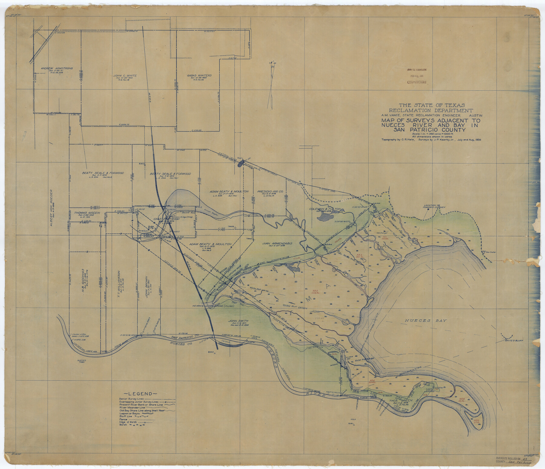
San Patricio County Rolled Sketch 29
Map of surveys adjacent to Nueces River and Bay in San Patricio County
-
Map/Doc
9893
-
Collection
General Map Collection
-
Object Dates
1934 (Survey Date)
1934/9/28 (File Date)
-
People and Organizations
State of Texas Reclamation Department (Publisher)
A.M. Vance (Surveyor/Engineer)
C.R. Hale (Surveyor/Engineer)
J.P. Kearby, Jr. (Surveyor/Engineer)
-
Counties
San Patricio
-
Subjects
Surveying Rolled Sketch
-
Height x Width
39.2 x 45.5 inches
99.6 x 115.6 cm
-
Medium
blueprint/diazo
-
Scale
1" = 360 varas
Part of: General Map Collection
Loving County Rolled Sketch 17

Print $40.00
- Digital $50.00
Loving County Rolled Sketch 17
2022
Size 38.2 x 49.3 inches
Map/Doc 97292
Hood County Sketch File 7

Print $6.00
- Digital $50.00
Hood County Sketch File 7
Size 12.9 x 7.9 inches
Map/Doc 26581
Irion County Rolled Sketch 25

Print $20.00
- Digital $50.00
Irion County Rolled Sketch 25
2008
Size 35.7 x 24.4 inches
Map/Doc 89227
Grundriss von Neu-Orleans nach den manuscripten in dem schatze der karten der marine

Print $20.00
- Digital $50.00
Grundriss von Neu-Orleans nach den manuscripten in dem schatze der karten der marine
1744
Size 9.6 x 14.1 inches
Map/Doc 94109
Stephens County Working Sketch 40

Print $20.00
- Digital $50.00
Stephens County Working Sketch 40
2006
Size 26.9 x 34.0 inches
Map/Doc 87149
Kinney County Sketch File 35

Print $6.00
- Digital $50.00
Kinney County Sketch File 35
1944
Size 14.2 x 8.7 inches
Map/Doc 29185
Jim Wells County Working Sketch 3

Print $20.00
- Digital $50.00
Jim Wells County Working Sketch 3
1936
Size 27.7 x 24.5 inches
Map/Doc 66601
Hutchinson County Boundary File 2

Print $2.00
- Digital $50.00
Hutchinson County Boundary File 2
Size 11.2 x 8.8 inches
Map/Doc 55302
Map of the Fort Worth & Denver City Railway, Wichita County, Texas

Print $40.00
- Digital $50.00
Map of the Fort Worth & Denver City Railway, Wichita County, Texas
1885
Size 23.7 x 66.5 inches
Map/Doc 64455

Leon County Working Sketch 5

Print $20.00
- Digital $50.00
Leon County Working Sketch 5
1905
Size 40.5 x 20.6 inches
Map/Doc 70404
Tyler County Rolled Sketch 5

Print $20.00
- Digital $50.00
Tyler County Rolled Sketch 5
1954
Size 29.3 x 40.0 inches
Map/Doc 8057
You may also like
Flight Mission No. DQO-11K, Frame 19, Galveston County

Print $20.00
- Digital $50.00
Flight Mission No. DQO-11K, Frame 19, Galveston County
1952
Size 18.6 x 22.4 inches
Map/Doc 85213
North Part Brewster Co.

Print $40.00
- Digital $50.00
North Part Brewster Co.
1914
Size 40.1 x 48.6 inches
Map/Doc 66731
Palo Pinto County Working Sketch 13

Print $20.00
- Digital $50.00
Palo Pinto County Working Sketch 13
1947
Size 27.4 x 24.2 inches
Map/Doc 71396
Caldwell County

Print $20.00
- Digital $50.00
Caldwell County
1854
Size 20.0 x 20.5 inches
Map/Doc 3354
La Salle County Working Sketch 3

Print $20.00
- Digital $50.00
La Salle County Working Sketch 3
1914
Size 15.0 x 14.2 inches
Map/Doc 70304
[State Capitol Leagues, County School Leagues, and vicinity]
![92535, [State Capitol Leagues, County School Leagues, and vicinity], Twichell Survey Records](https://historictexasmaps.com/wmedia_w700/maps/92535-1.tif.jpg)
Print $20.00
- Digital $50.00
[State Capitol Leagues, County School Leagues, and vicinity]
1913
Size 20.8 x 27.6 inches
Map/Doc 92535
Map of Red River Division of International & Great Northern Railroad

Print $40.00
- Digital $50.00
Map of Red River Division of International & Great Northern Railroad
Size 23.5 x 103.4 inches
Map/Doc 64475
Montgomery County Rolled Sketch 13

Print $40.00
- Digital $50.00
Montgomery County Rolled Sketch 13
1932
Size 37.9 x 57.3 inches
Map/Doc 9526
Township 14 South Range 15 West of the Louisiana Meridian, Louisiana

Print $20.00
- Digital $50.00
Township 14 South Range 15 West of the Louisiana Meridian, Louisiana
1875
Size 19.6 x 24.6 inches
Map/Doc 65859
[Surveys along the Cibolo, Balcones and Leon Creeks]
![69728, [Surveys along the Cibolo, Balcones and Leon Creeks], General Map Collection](https://historictexasmaps.com/wmedia_w700/maps/69728-1.tif.jpg)
Print $20.00
- Digital $50.00
[Surveys along the Cibolo, Balcones and Leon Creeks]
1841
Size 14.5 x 21.0 inches
Map/Doc 69728
Le Cours de Fleuve Missisipi, selon les relations les plus modernes

Print $20.00
- Digital $50.00
Le Cours de Fleuve Missisipi, selon les relations les plus modernes
1737
Size 16.4 x 19.3 inches
Map/Doc 94001
