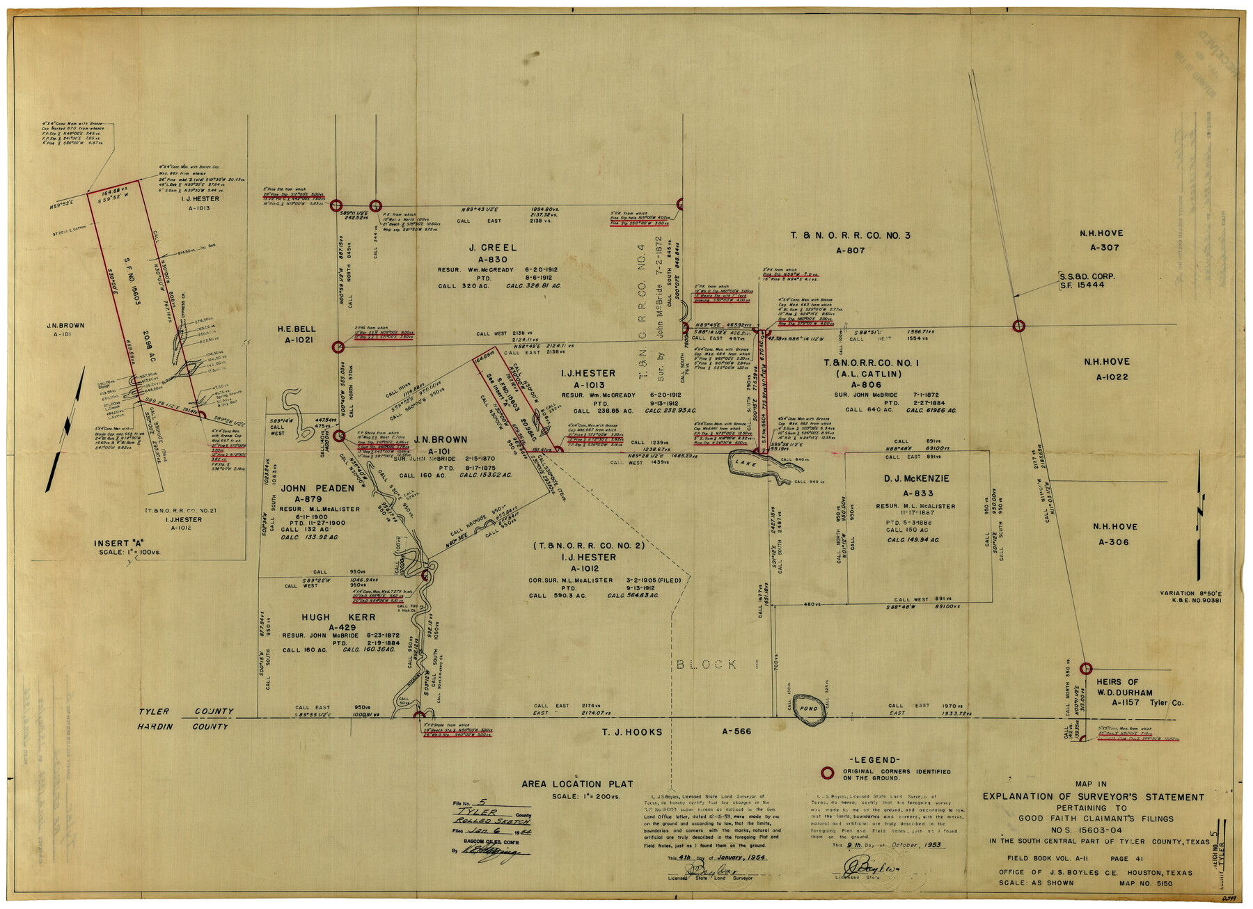
Tyler County Rolled Sketch 5
Map in explanation of surveyor's statement pertaining to Good Faith Claimant's filings nos. 15603-04 in the south central part of Tyler County, Texas
-
Map/Doc
8057
-
Collection
General Map Collection
-
Object Dates
1/4/1954 (Creation Date)
1/6/1954 (File Date)
-
People and Organizations
J.S. Boyles (Surveyor/Engineer)
-
Counties
Tyler
-
Subjects
Surveying Rolled Sketch
-
Height x Width
29.3 x 40.0 inches
74.4 x 101.6 cm
-
Medium
blueprint/diazo
-
Scale
1" = 200 varas
Part of: General Map Collection
Crockett County Rolled Sketch 99

Print $20.00
- Digital $50.00
Crockett County Rolled Sketch 99
Size 37.2 x 38.2 inches
Map/Doc 95401
Newton County Working Sketch 18

Print $20.00
- Digital $50.00
Newton County Working Sketch 18
1950
Size 14.3 x 13.6 inches
Map/Doc 71264
[Surveys along the Nueces River, San Patricio District]
![69739, [Surveys along the Nueces River, San Patricio District], General Map Collection](https://historictexasmaps.com/wmedia_w700/maps/69739.tif.jpg)
Print $2.00
- Digital $50.00
[Surveys along the Nueces River, San Patricio District]
1842
Size 11.3 x 7.7 inches
Map/Doc 69739
Map of Polk County

Print $20.00
- Digital $50.00
Map of Polk County
1879
Size 27.1 x 20.8 inches
Map/Doc 3959
Texas Gulf Coast Map from the Sabine River to the Rio Grande as subdivided for mineral development

Print $40.00
- Digital $50.00
Texas Gulf Coast Map from the Sabine River to the Rio Grande as subdivided for mineral development
1948
Size 49.3 x 55.7 inches
Map/Doc 2906
Flight Mission No. DQN-2K, Frame 94, Calhoun County

Print $20.00
- Digital $50.00
Flight Mission No. DQN-2K, Frame 94, Calhoun County
1953
Size 16.6 x 16.2 inches
Map/Doc 84284
Flight Mission No. BRE-2P, Frame 124, Nueces County

Print $20.00
- Digital $50.00
Flight Mission No. BRE-2P, Frame 124, Nueces County
1956
Size 18.3 x 22.3 inches
Map/Doc 86800

Flight Mission No. CRK-8P, Frame 101, Refugio County

Print $20.00
- Digital $50.00
Flight Mission No. CRK-8P, Frame 101, Refugio County
1956
Size 18.7 x 22.3 inches
Map/Doc 86962
Flight Mission No. DAG-21K, Frame 126, Matagorda County

Print $20.00
- Digital $50.00
Flight Mission No. DAG-21K, Frame 126, Matagorda County
1952
Size 18.5 x 22.3 inches
Map/Doc 86452
Randall County Sketch File 12

Print $6.00
- Digital $50.00
Randall County Sketch File 12
1945
Size 11.3 x 8.9 inches
Map/Doc 34976
Galveston County Sketch File 61a

Print $12.00
- Digital $50.00
Galveston County Sketch File 61a
1988
Size 11.2 x 8.8 inches
Map/Doc 23665
You may also like

Kleberg County Rolled Sketch 10-34

Print $20.00
- Digital $50.00
Kleberg County Rolled Sketch 10-34
1952
Size 38.2 x 32.3 inches
Map/Doc 9384

Upton County Boundary File 1b

Print $28.00
- Digital $50.00
Upton County Boundary File 1b
Size 13.5 x 9.1 inches
Map/Doc 59512
Gonzales County Sketch File 5

Print $16.00
- Digital $50.00
Gonzales County Sketch File 5
1879
Size 10.0 x 8.1 inches
Map/Doc 24377
Flight Mission No. DQO-2K, Frame 89, Galveston County

Print $20.00
- Digital $50.00
Flight Mission No. DQO-2K, Frame 89, Galveston County
1952
Size 18.6 x 22.3 inches
Map/Doc 85016
Coryell County Working Sketch 13

Print $20.00
- Digital $50.00
Coryell County Working Sketch 13
1950
Size 20.9 x 22.7 inches
Map/Doc 68220
Crane County Rolled Sketch 29

Print $20.00
- Digital $50.00
Crane County Rolled Sketch 29
2024
Size 24.6 x 35.5 inches
Map/Doc 97338
Flight Mission No. DQN-5K, Frame 61, Calhoun County

Print $20.00
- Digital $50.00
Flight Mission No. DQN-5K, Frame 61, Calhoun County
1953
Size 18.7 x 22.3 inches
Map/Doc 84404

Milam County Boundary File 4

Print $4.00
- Digital $50.00
Milam County Boundary File 4
Size 13.3 x 8.2 inches
Map/Doc 57221
Parker County Sketch File 9

Print $4.00
- Digital $50.00
Parker County Sketch File 9
Size 8.1 x 10.0 inches
Map/Doc 33538