Kleberg County Rolled Sketch 10-34
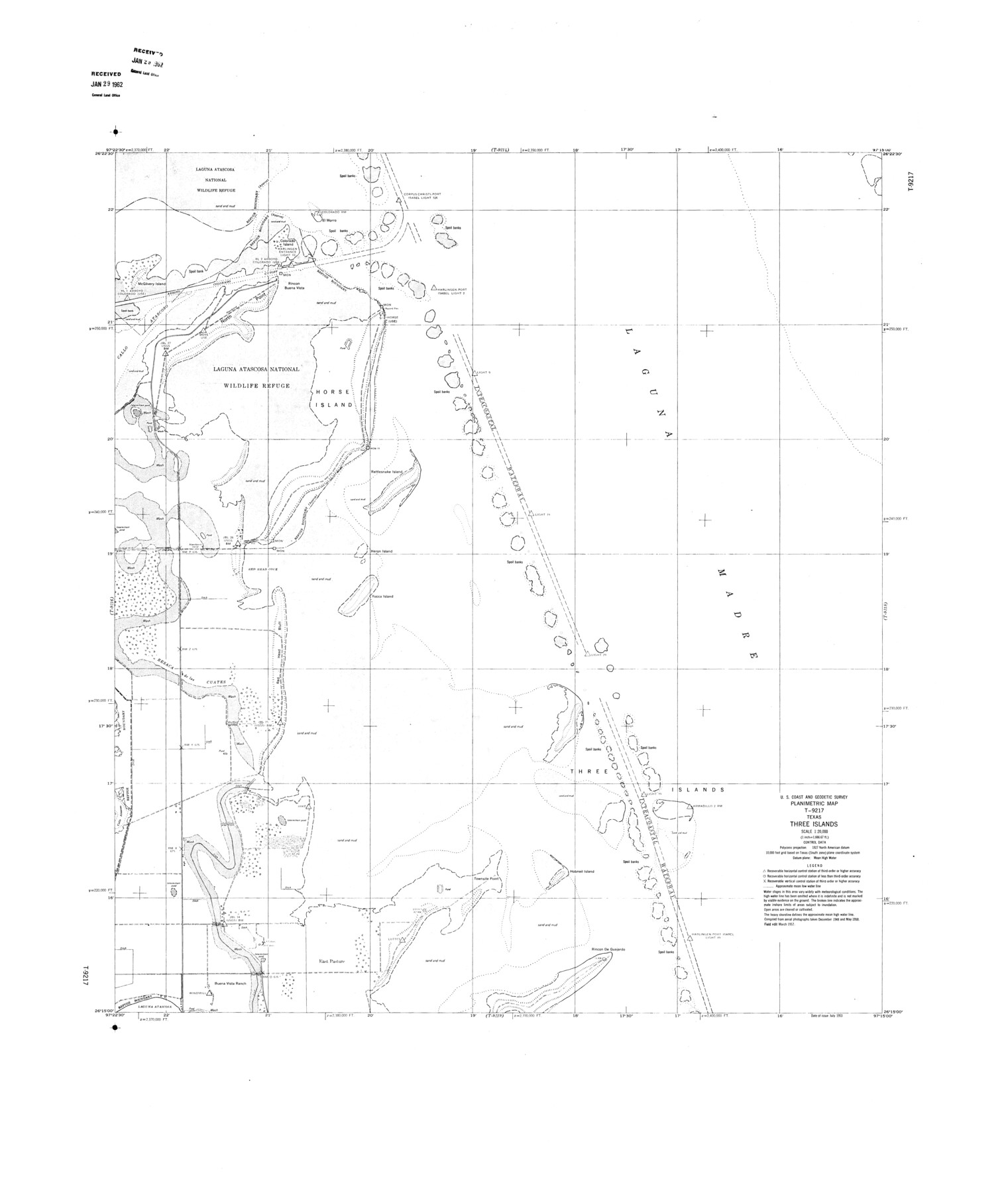
Planimetric Map T-9217, Texas, Three Islands
-
Map/Doc
9384
-
Collection
General Map Collection
-
Object Dates
1952 (Creation Date)
1962/1/29 (File Date)
-
People and Organizations
U.S. Coast and Geodetic Survey (Publisher)
-
Counties
Willacy
-
Subjects
Surveying Rolled Sketch
-
Height x Width
38.2 x 32.3 inches
97.0 x 82.0 cm
-
Scale
1" = 1666.67 feet
Part of: General Map Collection
Ward County Working Sketch 54

Print $40.00
- Digital $50.00
Ward County Working Sketch 54
1978
Size 24.1 x 48.8 inches
Map/Doc 72360
Hudspeth County Working Sketch 32

Print $20.00
- Digital $50.00
Hudspeth County Working Sketch 32
1972
Size 21.6 x 31.7 inches
Map/Doc 66316
Upshur County Working Sketch 6

Print $20.00
- Digital $50.00
Upshur County Working Sketch 6
1943
Size 28.6 x 34.3 inches
Map/Doc 69562
Menard County Boundary File 3a

Print $4.00
- Digital $50.00
Menard County Boundary File 3a
Size 10.6 x 8.1 inches
Map/Doc 57074
United States - Gulf Coast - Galveston to Rio Grande

Print $20.00
- Digital $50.00
United States - Gulf Coast - Galveston to Rio Grande
1941
Size 26.6 x 18.5 inches
Map/Doc 72752

Bailey County Working Sketch Graphic Index

Print $20.00
- Digital $50.00
Bailey County Working Sketch Graphic Index
1956
Size 47.7 x 30.5 inches
Map/Doc 76460
Parmer County Sketch File 1

Print $28.00
- Digital $50.00
Parmer County Sketch File 1
1902
Size 10.6 x 8.2 inches
Map/Doc 33621
Flight Mission No. DQO-3K, Frame 31, Galveston County

Print $20.00
- Digital $50.00
Flight Mission No. DQO-3K, Frame 31, Galveston County
1952
Size 18.9 x 22.5 inches
Map/Doc 85072
Terrell County Working Sketch 81

Print $20.00
- Digital $50.00
Terrell County Working Sketch 81
1988
Size 28.4 x 36.0 inches
Map/Doc 69602
Morris County Rolled Sketch 2A

Print $20.00
- Digital $50.00
Morris County Rolled Sketch 2A
Size 24.0 x 18.8 inches
Map/Doc 10228
Val Verde County Working Sketch 66

Print $20.00
- Digital $50.00
Val Verde County Working Sketch 66
1964
Size 42.1 x 46.9 inches
Map/Doc 72201
You may also like
Current Miscellaneous File 11

Print $50.00
- Digital $50.00
Current Miscellaneous File 11
1930
Size 11.2 x 8.7 inches
Map/Doc 73778
Padre Island National Seashore, Texas - Dependent Resurvey

Print $4.00
- Digital $50.00
Padre Island National Seashore, Texas - Dependent Resurvey
2001
Size 18.4 x 24.0 inches
Map/Doc 60549
Burnet County Working Sketch 6

Print $20.00
- Digital $50.00
Burnet County Working Sketch 6
1958
Size 20.5 x 31.0 inches
Map/Doc 67849
Duval County Rolled Sketch 38

Print $20.00
- Digital $50.00
Duval County Rolled Sketch 38
1937
Size 22.6 x 16.1 inches
Map/Doc 5755
Medina County Working Sketch 17

Print $20.00
- Digital $50.00
Medina County Working Sketch 17
1979
Size 26.8 x 34.5 inches
Map/Doc 70932
Pecos County Working Sketch 69

Print $40.00
- Digital $50.00
Pecos County Working Sketch 69
1956
Size 48.7 x 32.6 inches
Map/Doc 71541
The MKT - Texas Empire of the South

Print $20.00
- Digital $50.00
The MKT - Texas Empire of the South
1905
Size 18.5 x 40.6 inches
Map/Doc 97035
Map of Crockett County

Print $40.00
- Digital $50.00
Map of Crockett County
1878
Size 60.2 x 97.2 inches
Map/Doc 78701
Sketch Showing Surveys Made for W. R. Cartledge

Print $20.00
- Digital $50.00
Sketch Showing Surveys Made for W. R. Cartledge
1945
Size 17.3 x 13.8 inches
Map/Doc 60296
Andrews County Rolled Sketch 29

Print $20.00
- Digital $50.00
Andrews County Rolled Sketch 29
1949
Size 36.6 x 16.3 inches
Map/Doc 77173
University Land Field Notes for Blocks A, B, C, D, E, F, G, H, I, and J in Hudspeth County

University Land Field Notes for Blocks A, B, C, D, E, F, G, H, I, and J in Hudspeth County
Map/Doc 81712
Young County Rolled Sketch 15

Print $20.00
- Digital $50.00
Young County Rolled Sketch 15
Size 18.0 x 22.7 inches
Map/Doc 8303