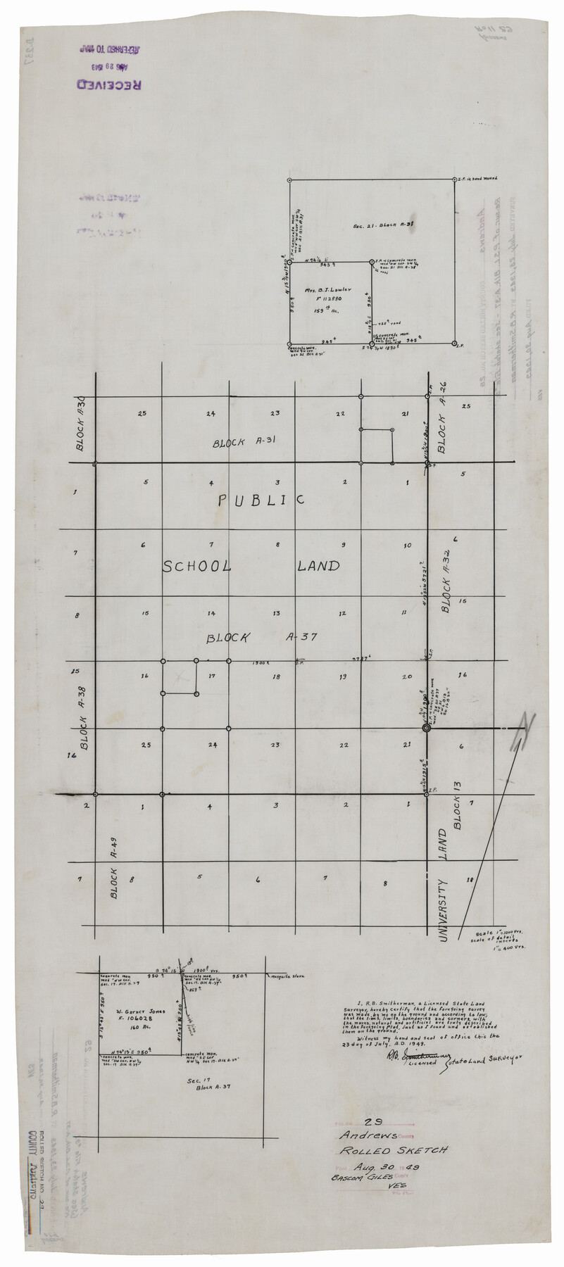
Andrews County Rolled Sketch 29
[Sketch of surveys in PSL Block A-31 and A-37]
-
Map/Doc
77173
-
Collection
General Map Collection
-
Object Dates
1949/7/23 (Creation Date)
1949/8/30 (File Date)
-
People and Organizations
R.B. Smitherman (Surveyor/Engineer)
-
Counties
Andrews
-
Subjects
Surveying Rolled Sketch
-
Height x Width
36.6 x 16.3 inches
93.0 x 41.4 cm
-
Medium
linen, manuscript
-
Comments
See Andrews County Sketch File 9 (12853) for surveyor’s report.
Related maps
Andrews County Sketch File 9

Print $8.00
- Digital $50.00
Andrews County Sketch File 9
1949
Size 14.2 x 8.6 inches
Map/Doc 12853
Part of: General Map Collection
Matagorda County Sketch File 31

Print $4.00
- Digital $50.00
Matagorda County Sketch File 31
1919
Size 11.4 x 8.2 inches
Map/Doc 30815
Hardin County Rolled Sketch 18

Print $20.00
- Digital $50.00
Hardin County Rolled Sketch 18
1953
Size 35.8 x 24.4 inches
Map/Doc 6088
West Half - Brown County

Print $40.00
- Digital $50.00
West Half - Brown County
1982
Size 142.2 x 37.3 inches
Map/Doc 97384
Dickens County Rolled Sketch 5A

Print $40.00
- Digital $50.00
Dickens County Rolled Sketch 5A
1947
Size 60.3 x 40.9 inches
Map/Doc 8788
Andrews County Rolled Sketch 27

Print $40.00
- Digital $50.00
Andrews County Rolled Sketch 27
1947
Size 19.0 x 118.7 inches
Map/Doc 8399
Briscoe County Rolled Sketch 14

Print $40.00
- Digital $50.00
Briscoe County Rolled Sketch 14
1913
Size 36.0 x 48.9 inches
Map/Doc 8529

Parker County Rolled Sketch 7

Print $20.00
- Digital $50.00
Parker County Rolled Sketch 7
Size 24.5 x 19.1 inches
Map/Doc 89050

Comal County Sketch File 16

Print $4.00
- Digital $50.00
Comal County Sketch File 16
1878
Size 8.4 x 10.7 inches
Map/Doc 19034
Webb County Sketch File 14c

Print $20.00
- Digital $50.00
Webb County Sketch File 14c
1892
Size 20.5 x 13.0 inches
Map/Doc 12633
DeWitt County Rolled Sketch 2

Print $20.00
- Digital $50.00
DeWitt County Rolled Sketch 2
1943
Size 32.0 x 42.7 inches
Map/Doc 8778
You may also like
St. Louis, Arkansas & Texas R'y, Lufkin Branch, Formerly the Kansas & Gulf Short Line

Print $20.00
- Digital $50.00
St. Louis, Arkansas & Texas R'y, Lufkin Branch, Formerly the Kansas & Gulf Short Line
1888
Size 10.5 x 42.8 inches
Map/Doc 64271
[Capitol Leagues in Lamb County]
![91015, [Capitol Leagues in Lamb County], Twichell Survey Records](https://historictexasmaps.com/wmedia_w700/maps/91015-1.tif.jpg)
Print $2.00
- Digital $50.00
[Capitol Leagues in Lamb County]
1912
Size 12.3 x 8.8 inches
Map/Doc 91015
Liles City, Gaines County, Texas

Print $20.00
- Digital $50.00
Liles City, Gaines County, Texas
Size 21.5 x 23.9 inches
Map/Doc 92683
Navasota River, Springfield Sheet

Print $20.00
- Digital $50.00
Navasota River, Springfield Sheet
1934
Size 41.5 x 37.8 inches
Map/Doc 65074
Sketch of Survey 3, Block 1 in Dickens and King Counties

Print $20.00
- Digital $50.00
Sketch of Survey 3, Block 1 in Dickens and King Counties
1914
Size 10.0 x 27.5 inches
Map/Doc 10765
General Highway Map, Jasper County, Texas

Print $20.00
General Highway Map, Jasper County, Texas
1961
Size 18.2 x 24.8 inches
Map/Doc 79534
FT. W. & R. G. Ry. Right of Way Map, Whiteland to Lightner, Concho County, Texas

Print $40.00
- Digital $50.00
FT. W. & R. G. Ry. Right of Way Map, Whiteland to Lightner, Concho County, Texas
1918
Size 39.6 x 121.3 inches
Map/Doc 61412
San Saba County Sketch File 18

Print $12.00
- Digital $50.00
San Saba County Sketch File 18
1919
Size 11.4 x 8.8 inches
Map/Doc 36460
[Connecting lines through Blocks A2, 29, I, GG, I. & G. N. Block 1 and Archer County School Land]
![91646, [Connecting lines through Blocks A2, 29, I, GG, I. & G. N. Block 1 and Archer County School Land], Twichell Survey Records](https://historictexasmaps.com/wmedia_w700/maps/91646-1.tif.jpg)
Print $20.00
- Digital $50.00
[Connecting lines through Blocks A2, 29, I, GG, I. & G. N. Block 1 and Archer County School Land]
Size 26.2 x 18.8 inches
Map/Doc 91646
Hardin County Sketch File 24b

Print $4.00
- Digital $50.00
Hardin County Sketch File 24b
Size 6.4 x 8.0 inches
Map/Doc 25146
Crane County, Texas

Print $20.00
- Digital $50.00
Crane County, Texas
1889
Size 22.5 x 18.0 inches
Map/Doc 721
Reagan County Working Sketch 14b

Print $20.00
- Digital $50.00
Reagan County Working Sketch 14b
Size 20.3 x 9.0 inches
Map/Doc 71855