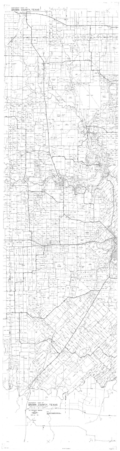
West Half - Brown County
-
Map/Doc
97384
-
Collection
General Map Collection
-
Object Dates
1982 (Creation Date)
-
People and Organizations
Don T. King (Donor)
Don T. King (Surveyor/Engineer)
-
Counties
Brown
-
Subjects
County
-
Height x Width
142.2 x 37.3 inches
361.2 x 94.7 cm
-
Comments
For east half of map, see 97385.
Related maps
East Half - Brown County

Print $40.00
- Digital $50.00
East Half - Brown County
1982
Size 141.3 x 36.8 inches
Map/Doc 97385
Part of: General Map Collection
Travis County Sketch File 75B

Print $20.00
- Digital $50.00
Travis County Sketch File 75B
1992
Size 37.4 x 26.7 inches
Map/Doc 12479
H No. 2 - Preliminary Sketch of Mobile Bay

Print $20.00
- Digital $50.00
H No. 2 - Preliminary Sketch of Mobile Bay
1852
Size 19.4 x 15.2 inches
Map/Doc 97223
No. 7 Presidio County

Print $20.00
- Digital $50.00
No. 7 Presidio County
Size 23.9 x 26.2 inches
Map/Doc 3969
Chambers County Sketch File 47

Print $211.00
- Digital $50.00
Chambers County Sketch File 47
1927
Size 14.3 x 9.0 inches
Map/Doc 17899
Liberty County Working Sketch 67

Print $20.00
- Digital $50.00
Liberty County Working Sketch 67
1971
Size 35.3 x 44.5 inches
Map/Doc 70527
Wilbarger County Working Sketch 14

Print $20.00
- Digital $50.00
Wilbarger County Working Sketch 14
1955
Size 24.8 x 21.7 inches
Map/Doc 72552
Castro County

Print $20.00
- Digital $50.00
Castro County
1932
Size 44.2 x 38.7 inches
Map/Doc 95451
Kuechler's Corners, Texas & Pacific Ry. Co. 80 Mile Reserve

Print $703.00
- Digital $50.00
Kuechler's Corners, Texas & Pacific Ry. Co. 80 Mile Reserve
1934
Size 11.0 x 8.5 inches
Map/Doc 2248
Controlled Mosaic by Jack Amman Photogrammetric Engineers, Inc - Sheet 22

Print $20.00
- Digital $50.00
Controlled Mosaic by Jack Amman Photogrammetric Engineers, Inc - Sheet 22
1954
Size 20.0 x 24.0 inches
Map/Doc 83471
Mills County Working Sketch 9

Print $20.00
- Digital $50.00
Mills County Working Sketch 9
1915
Size 13.3 x 13.7 inches
Map/Doc 71039
Crockett County Sketch File 66

Print $6.00
- Digital $50.00
Crockett County Sketch File 66
1927
Size 10.2 x 11.3 inches
Map/Doc 19853
El Paso County Rolled Sketch 44

Print $129.00
- Digital $50.00
El Paso County Rolled Sketch 44
1902
Size 10.4 x 15.5 inches
Map/Doc 44430
You may also like
Flight Mission No. BQR-4K, Frame 66, Brazoria County

Print $20.00
- Digital $50.00
Flight Mission No. BQR-4K, Frame 66, Brazoria County
1952
Size 18.8 x 22.5 inches
Map/Doc 83999
[T. & P. Block 44, Township 1S]
![90814, [T. & P. Block 44, Township 1S], Twichell Survey Records](https://historictexasmaps.com/wmedia_w700/maps/90814-2.tif.jpg)
Print $20.00
- Digital $50.00
[T. & P. Block 44, Township 1S]
Size 10.4 x 23.2 inches
Map/Doc 90814
Leon County Texas

Print $20.00
- Digital $50.00
Leon County Texas
1896
Size 25.4 x 22.1 inches
Map/Doc 3806
Marion County Working Sketch 42

Print $20.00
- Digital $50.00
Marion County Working Sketch 42
2000
Size 29.6 x 41.4 inches
Map/Doc 70818
Eastland County Working Sketch 21

Print $20.00
- Digital $50.00
Eastland County Working Sketch 21
1920
Size 15.4 x 22.7 inches
Map/Doc 68802
Rains County Sketch File 1

Print $6.00
- Digital $50.00
Rains County Sketch File 1
Size 5.9 x 9.1 inches
Map/Doc 34942
Cooke County Working Sketch 4

Print $20.00
- Digital $50.00
Cooke County Working Sketch 4
1926
Size 23.5 x 17.6 inches
Map/Doc 68241
Galveston Bay Oil Area, Galveston, Harris, Chambers and Brazoria Cos.

Print $40.00
- Digital $50.00
Galveston Bay Oil Area, Galveston, Harris, Chambers and Brazoria Cos.
1927
Size 52.9 x 40.8 inches
Map/Doc 2938
Hockley County

Print $20.00
- Digital $50.00
Hockley County
1897
Size 19.1 x 20.5 inches
Map/Doc 3675
Baylor County Sketch File 18

Print $6.00
- Digital $50.00
Baylor County Sketch File 18
1887
Size 11.1 x 13.2 inches
Map/Doc 14191
Eastland County Sketch File 12

Print $10.00
- Digital $50.00
Eastland County Sketch File 12
1879
Size 9.3 x 8.4 inches
Map/Doc 21588
Flight Mission No. DAG-21K, Frame 90, Matagorda County

Print $20.00
- Digital $50.00
Flight Mission No. DAG-21K, Frame 90, Matagorda County
1952
Size 18.5 x 22.2 inches
Map/Doc 86419