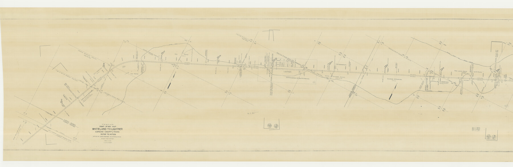
FT. W. & R. G. Ry. Right of Way Map, Whiteland to Lightner, Concho County, Texas
M.P. 197 to M.P. 209
Z-2-220, N.1.46
-
Map/Doc
61412
-
Collection
General Map Collection
-
Object Dates
1918 (Creation Date)
-
People and Organizations
Office of Chief Engineer (Publisher)
-
Counties
Concho Menard McCulloch
-
Subjects
Railroads
-
Height x Width
39.6 x 121.3 inches
100.6 x 308.1 cm
-
Medium
paper, photocopy
-
Scale
1 inch = 400 feet
-
Comments
See 61413 for related segment.
-
Features
FW&RG
Lightner
South Fork of Brady Creek
Reubes Creek
Part of: General Map Collection
Erath County Working Sketch 36

Print $20.00
- Digital $50.00
Erath County Working Sketch 36
1973
Size 33.5 x 30.4 inches
Map/Doc 69117
Nacogdoches County Sketch File 16

Print $20.00
- Digital $50.00
Nacogdoches County Sketch File 16
1945
Size 24.6 x 18.5 inches
Map/Doc 42155
Map of Brown County

Print $20.00
- Digital $50.00
Map of Brown County
1876
Size 25.9 x 23.3 inches
Map/Doc 3341
Fannin County Sketch File 10

Print $20.00
- Digital $50.00
Fannin County Sketch File 10
Size 21.0 x 16.0 inches
Map/Doc 11471
Flight Mission No. CRC-5R, Frame 43, Chambers County

Print $20.00
- Digital $50.00
Flight Mission No. CRC-5R, Frame 43, Chambers County
1956
Size 18.6 x 22.3 inches
Map/Doc 84962
Kimble County Rolled Sketch 23

Print $20.00
- Digital $50.00
Kimble County Rolled Sketch 23
Size 16.0 x 21.0 inches
Map/Doc 6513

La Salle County Working Sketch 15

Print $20.00
- Digital $50.00
La Salle County Working Sketch 15
1935
Size 27.4 x 17.2 inches
Map/Doc 70316
Flight Mission No. DQN-3K, Frame 74, Calhoun County

Print $20.00
- Digital $50.00
Flight Mission No. DQN-3K, Frame 74, Calhoun County
1953
Size 16.2 x 16.1 inches
Map/Doc 84365
Jefferson County Rolled Sketch 28

Print $20.00
- Digital $50.00
Jefferson County Rolled Sketch 28
1948
Size 22.4 x 32.9 inches
Map/Doc 6391
Jeff Davis County Working Sketch Graphic Index - west part

Print $20.00
- Digital $50.00
Jeff Davis County Working Sketch Graphic Index - west part
1977
Size 34.0 x 45.3 inches
Map/Doc 76594
Zavalla County

Print $20.00
- Digital $50.00
Zavalla County
1879
Size 21.3 x 25.0 inches
Map/Doc 4645
You may also like
San Augustine County Working Sketch 8

Print $20.00
- Digital $50.00
San Augustine County Working Sketch 8
1935
Size 24.8 x 35.0 inches
Map/Doc 63695
[Sketch showing surveys in the south half of Potter County, Blocks 6, 20-E, JAD, M-3, S, B. S. & F. Blocks 1 and 9, and A. B. and M. Block 2]
![91741, [Sketch showing surveys in the south half of Potter County, Blocks 6, 20-E, JAD, M-3, S, B. S. & F. Blocks 1 and 9, and A. B. and M. Block 2], Twichell Survey Records](https://historictexasmaps.com/wmedia_w700/maps/91741-1.tif.jpg)
Print $20.00
- Digital $50.00
[Sketch showing surveys in the south half of Potter County, Blocks 6, 20-E, JAD, M-3, S, B. S. & F. Blocks 1 and 9, and A. B. and M. Block 2]
Size 40.5 x 18.1 inches
Map/Doc 91741
University of Texas System University Lands

Print $20.00
- Digital $50.00
University of Texas System University Lands
1936
Size 23.2 x 17.6 inches
Map/Doc 93236
Map showing resurvey of Capitol Leagues, Oldham Co., Texas

Print $40.00
- Digital $50.00
Map showing resurvey of Capitol Leagues, Oldham Co., Texas
1918
Size 38.6 x 51.0 inches
Map/Doc 1755
Flight Mission No. DQN-2K, Frame 97, Calhoun County

Print $20.00
- Digital $50.00
Flight Mission No. DQN-2K, Frame 97, Calhoun County
1953
Size 18.7 x 22.4 inches
Map/Doc 84287
Sterling County Rolled Sketch 13

Print $20.00
- Digital $50.00
Sterling County Rolled Sketch 13
1945
Size 34.9 x 27.3 inches
Map/Doc 7847
Erath County Boundary File 1

Print $8.00
- Digital $50.00
Erath County Boundary File 1
Size 13.1 x 8.8 inches
Map/Doc 53237
Crosby County Lands with Topographical Features

Print $2.00
- Digital $50.00
Crosby County Lands with Topographical Features
Size 8.7 x 11.2 inches
Map/Doc 90369
[Corpus Christi Bay, Padre Island, Mustang Island, Laguna de la Madre, King and Kenedy's Pasture]
![73041, [Corpus Christi Bay, Padre Island, Mustang Island, Laguna de la Madre, King and Kenedy's Pasture], General Map Collection](https://historictexasmaps.com/wmedia_w700/maps/73041.tif.jpg)
Print $20.00
- Digital $50.00
[Corpus Christi Bay, Padre Island, Mustang Island, Laguna de la Madre, King and Kenedy's Pasture]
Size 26.2 x 18.1 inches
Map/Doc 73041
Flight Mission No. DQO-8K, Frame 131, Galveston County

Print $20.00
- Digital $50.00
Flight Mission No. DQO-8K, Frame 131, Galveston County
1952
Size 18.7 x 22.5 inches
Map/Doc 85196
Flight Mission No. CRK-3P, Frame 67, Refugio County

Print $20.00
- Digital $50.00
Flight Mission No. CRK-3P, Frame 67, Refugio County
1956
Size 18.5 x 22.3 inches
Map/Doc 86909
Parker County Boundary File 1

Print $6.00
- Digital $50.00
Parker County Boundary File 1
Size 11.2 x 8.7 inches
Map/Doc 57833