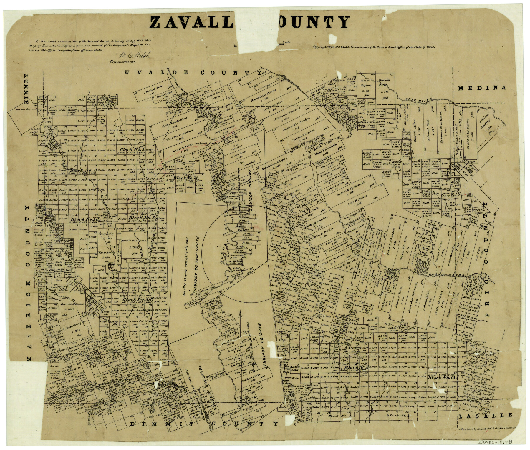
Zavalla County
-
Map/Doc
4645
-
Collection
General Map Collection
-
Object Dates
1879 (Creation Date)
-
People and Organizations
W.C. Walsh (GLO Commissioner)
August Gast & Co. (Lithographer)
-
Counties
Zavala
-
Subjects
County
-
Height x Width
21.3 x 25.0 inches
54.1 x 63.5 cm
-
Comments
Copyrighted 1879.
-
Features
Turkey Creek
Pendencia Creek
Pena Creek
Espantoso Lake
Anderson's Creek
Arroyo Negro
Comanche Creek
Mustang Creek
Palo Blanco Creek
Tortuga Creek
Frio River
Live Oak Creek
Chacon Creek
Leona River
Nueces River
Chaparosa Creek
Yolodigo Creek
General Wool's [sic] Crossing
Gato Creek
Part of: General Map Collection
Platter Quadrangle

Print $20.00
- Digital $50.00
Platter Quadrangle
1999
Size 35.4 x 23.4 inches
Map/Doc 97365
Terrell County

Print $20.00
- Digital $50.00
Terrell County
1905
Size 41.6 x 30.9 inches
Map/Doc 63061
Flight Mission No. DAG-23K, Frame 17, Matagorda County

Print $20.00
- Digital $50.00
Flight Mission No. DAG-23K, Frame 17, Matagorda County
1953
Size 18.5 x 22.2 inches
Map/Doc 86479
Hunt County Sketch File 49

Print $4.00
- Digital $50.00
Hunt County Sketch File 49
1852
Size 7.3 x 8.9 inches
Map/Doc 27168
Map of Clear Lake Shores

Print $20.00
- Digital $50.00
Map of Clear Lake Shores
1927
Size 36.9 x 46.2 inches
Map/Doc 4843
Lampasas County Sketch File 15

Print $20.00
- Digital $50.00
Lampasas County Sketch File 15
1888
Size 24.5 x 27.1 inches
Map/Doc 11975
Colorado River, Matagorda Sheet

Print $6.00
- Digital $50.00
Colorado River, Matagorda Sheet
1937
Size 30.9 x 35.8 inches
Map/Doc 65303
United States - Gulf Coast - Padre I. and Laguna Madre Lat. 27° 12' to Lat. 26° 33' Texas

Print $20.00
- Digital $50.00
United States - Gulf Coast - Padre I. and Laguna Madre Lat. 27° 12' to Lat. 26° 33' Texas
1913
Size 26.8 x 18.2 inches
Map/Doc 72815

Galveston County NRC Article 33.136 Sketch 71

Print $22.00
- Digital $50.00
Galveston County NRC Article 33.136 Sketch 71
2012
Size 24.0 x 36.0 inches
Map/Doc 94689
Val Verde County Sketch File 8

Print $38.00
- Digital $50.00
Val Verde County Sketch File 8
1885
Size 22.6 x 23.2 inches
Map/Doc 12564
Goliad County Working Sketch 9

Print $20.00
- Digital $50.00
Goliad County Working Sketch 9
1938
Size 19.3 x 27.6 inches
Map/Doc 63199
You may also like
Map of Adrian, the New Town in the Panhandle, Oldham County, Texas (verso - Adrian promotional text)

Print $20.00
- Digital $50.00
Map of Adrian, the New Town in the Panhandle, Oldham County, Texas (verso - Adrian promotional text)
Size 26.0 x 21.5 inches
Map/Doc 92136
Cooke County Sketch File 39

Print $20.00
- Digital $50.00
Cooke County Sketch File 39
1927
Size 10.9 x 18.2 inches
Map/Doc 11176
Medina County Sketch File 18

Print $40.00
- Digital $50.00
Medina County Sketch File 18
Size 23.1 x 10.5 inches
Map/Doc 31482
Hudspeth County Sketch File 14

Print $12.00
- Digital $50.00
Hudspeth County Sketch File 14
1915
Size 14.3 x 8.8 inches
Map/Doc 26938
Nueces County Rolled Sketch 72

Print $20.00
- Digital $50.00
Nueces County Rolled Sketch 72
1980
Size 18.1 x 25.8 inches
Map/Doc 6930
General Highway Map. Detail of Cities and Towns in Williamson County, Texas [Round Rock, Taylor, Georgetown]
![79714, General Highway Map. Detail of Cities and Towns in Williamson County, Texas [Round Rock, Taylor, Georgetown], Texas State Library and Archives](https://historictexasmaps.com/wmedia_w700/maps/79714.tif.jpg)
Print $20.00
General Highway Map. Detail of Cities and Towns in Williamson County, Texas [Round Rock, Taylor, Georgetown]
1961
Size 18.2 x 24.8 inches
Map/Doc 79714
[H. & T. C. RR. Company, Block 47, Sections 16- 28]
![91248, [H. & T. C. RR. Company, Block 47, Sections 16- 28], Twichell Survey Records](https://historictexasmaps.com/wmedia_w700/maps/91248-1.tif.jpg)
Print $20.00
- Digital $50.00
[H. & T. C. RR. Company, Block 47, Sections 16- 28]
Size 30.4 x 21.6 inches
Map/Doc 91248
Concho County Working Sketch 1

Print $20.00
- Digital $50.00
Concho County Working Sketch 1
Size 29.3 x 36.8 inches
Map/Doc 68183
Brewster County Rolled Sketch 134

Print $20.00
- Digital $50.00
Brewster County Rolled Sketch 134
Size 19.0 x 24.9 inches
Map/Doc 5303
Shelby County Sketch File 9

Print $4.00
- Digital $50.00
Shelby County Sketch File 9
1858
Size 9.4 x 8.2 inches
Map/Doc 36609
Flight Mission No. DQN-1K, Frame 102, Calhoun County

Print $20.00
- Digital $50.00
Flight Mission No. DQN-1K, Frame 102, Calhoun County
1953
Size 17.7 x 22.1 inches
Map/Doc 84169
Washington County

Print $20.00
- Digital $50.00
Washington County
1871
Size 11.9 x 27.7 inches
Map/Doc 4123