Lampasas County Sketch File 15
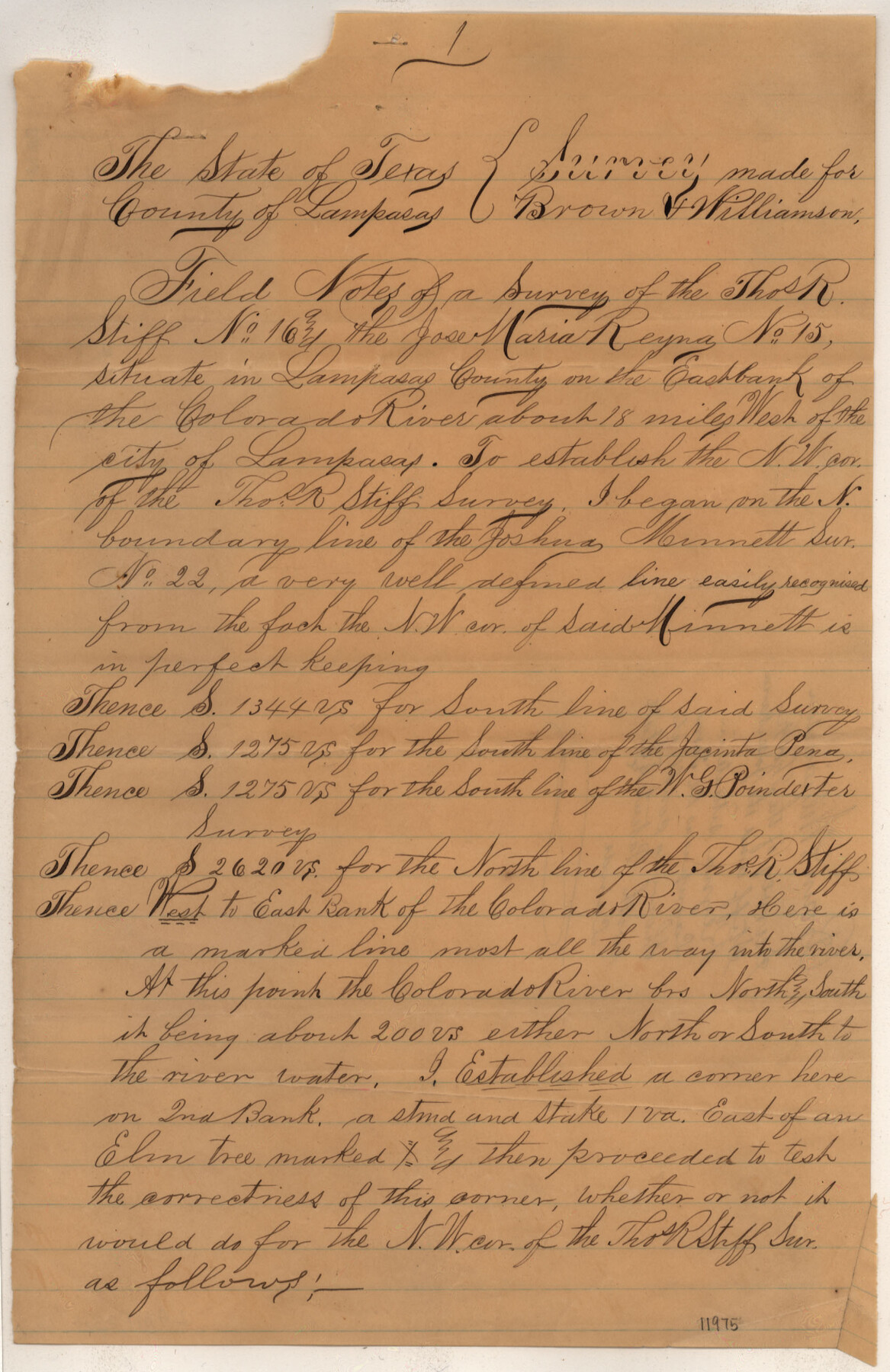
[Sketch and field notes of the Thos. Stiff league and surrounding area on the Colorado River due west of Lampasas]
-
Map/Doc
11975
-
Collection
General Map Collection
-
Object Dates
3/17/1888 (Creation Date)
4/19/1889 (File Date)
-
People and Organizations
E. Brown (Surveyor/Engineer)
G.W. Pool (Chainman)
Jas. Rhyan (Chainman)
-
Counties
Lampasas
-
Subjects
Surveying Sketch File
-
Height x Width
24.5 x 27.1 inches
62.2 x 68.8 cm
-
Medium
paper, manuscript
-
Features
Colorado River
Part of: General Map Collection
Map of Lampasas County

Print $40.00
- Digital $50.00
Map of Lampasas County
1900
Size 47.1 x 60.2 inches
Map/Doc 62971
Travis County

Print $20.00
- Digital $50.00
Travis County
1895
Size 47.8 x 46.4 inches
Map/Doc 82079
Coleman County Sketch File 3a

Print $20.00
- Digital $50.00
Coleman County Sketch File 3a
1857
Size 12.6 x 19.2 inches
Map/Doc 11117
Hays County Rolled Sketch 22

Print $20.00
- Digital $50.00
Hays County Rolled Sketch 22
1924
Size 19.4 x 20.6 inches
Map/Doc 6178
Uvalde County Boundary File 1a

Print $12.00
- Digital $50.00
Uvalde County Boundary File 1a
Size 14.5 x 8.9 inches
Map/Doc 59551
Matagorda County Sketch File 12

Print $2.00
- Digital $50.00
Matagorda County Sketch File 12
Size 8.4 x 7.0 inches
Map/Doc 30771
Pecos County Rolled Sketch 189

Print $20.00
- Digital $50.00
Pecos County Rolled Sketch 189
1998
Size 22.2 x 33.7 inches
Map/Doc 7307
Palo Pinto County Rolled Sketch 7

Print $20.00
- Digital $50.00
Palo Pinto County Rolled Sketch 7
Size 27.3 x 34.2 inches
Map/Doc 7190
Topographical Map of the Rio Grande, Sheet No. 14

Print $20.00
- Digital $50.00
Topographical Map of the Rio Grande, Sheet No. 14
1912
Map/Doc 89538
Foard County Sketch File 31

Print $6.00
- Digital $50.00
Foard County Sketch File 31
1945
Size 14.5 x 9.1 inches
Map/Doc 22861
Location of the Southern Kansas Railway of Texas, Roberts County, Texas

Print $40.00
- Digital $50.00
Location of the Southern Kansas Railway of Texas, Roberts County, Texas
1887
Size 20.0 x 75.1 inches
Map/Doc 64037
Flight Mission No. BRA-16M, Frame 89, Jefferson County

Print $20.00
- Digital $50.00
Flight Mission No. BRA-16M, Frame 89, Jefferson County
1953
Size 18.6 x 22.4 inches
Map/Doc 85701
You may also like
Archer County Sketch File 8a

Print $8.00
- Digital $50.00
Archer County Sketch File 8a
Size 8.8 x 7.1 inches
Map/Doc 13639

[H. & G. N. Block 1]
![90946, [H. & G. N. Block 1], Twichell Survey Records](https://historictexasmaps.com/wmedia_w700/maps/90946-1.tif.jpg)
Print $20.00
- Digital $50.00
[H. & G. N. Block 1]
1873
Size 17.7 x 14.5 inches
Map/Doc 90946
Flight Mission No. BRA-16M, Frame 142, Jefferson County

Print $20.00
- Digital $50.00
Flight Mission No. BRA-16M, Frame 142, Jefferson County
1953
Size 18.5 x 22.2 inches
Map/Doc 85748
Jefferson County Rolled Sketch 67

Print $20.00
- Digital $50.00
Jefferson County Rolled Sketch 67
2007
Size 21.1 x 23.6 inches
Map/Doc 93426
Map of Mexico, Including Yucatan & Upper California, exhibiting the Chief Cities and Towns, the Principal Travelling Routes &c.

Print $20.00
- Digital $50.00
Map of Mexico, Including Yucatan & Upper California, exhibiting the Chief Cities and Towns, the Principal Travelling Routes &c.
1847
Size 33.3 x 25.4 inches
Map/Doc 95697
North end of Brazos Island

Print $20.00
- Digital $50.00
North end of Brazos Island
Size 26.0 x 18.3 inches
Map/Doc 72915
Montgomery County Rolled Sketch 17

Print $20.00
- Digital $50.00
Montgomery County Rolled Sketch 17
1932
Size 26.6 x 34.9 inches
Map/Doc 6805
University Land Field Note Volume Index

University Land Field Note Volume Index
2023
Size 8.5 x 11.0 inches
Map/Doc 97177
Map of the 1st, 2nd and 3rd Sections of Houston & Texas Central Railroad

Print $40.00
- Digital $50.00
Map of the 1st, 2nd and 3rd Sections of Houston & Texas Central Railroad
Size 30.7 x 64.6 inches
Map/Doc 64478
Edwards County Sketch File 10b

Print $20.00
- Digital $50.00
Edwards County Sketch File 10b
1903
Size 17.0 x 18.9 inches
Map/Doc 11423
Nueces County Rolled Sketch 133

Print $26.00
Nueces County Rolled Sketch 133
2001
Size 24.8 x 36.8 inches
Map/Doc 7168